Bereg County
| Bereg County Comitatus Bereghiensis (Latin) Bereg vármegye (Hungarian) Komitat Bereg (German) | |||||
| County of the Kingdom of Hungary | |||||
| |||||
.svg.png) | |||||
 | |||||
| Capital | Beregszász 48°12′N 22°39′E / 48.200°N 22.650°ECoordinates: 48°12′N 22°39′E / 48.200°N 22.650°E | ||||
| History | |||||
| • | Established | 12th century | |||
| • | Treaty of Trianon | June 4, 1920 | |||
| Area | |||||
| • | 1910 | 3,786 km2 (1,462 sq mi) | |||
| Population | |||||
| • | 1910 | 236,611 | |||
| Density | 62.5 /km2 (161.9 /sq mi) | ||||
| Today part of | |||||
| Berehove is the current name of the capital. | |||||
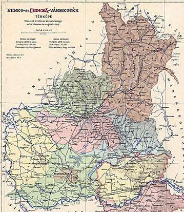
Bereg (Rusyn: Береґ; German: Berg) was an administrative county (comitatus) of the Kingdom of Hungary. Its territory is now in northeastern Hungary and western Ukraine. The capital of the county was Beregszász ("Berehove" in Ukrainian, Berehovo in Rusyn, Bergsaß in German, Beregovo in Russian, Bereg in Romanian).
Geography
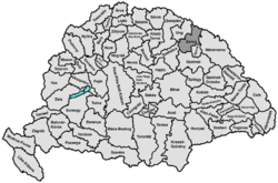
Bereg county shared borders with the Austrian crownland Galicia (now in Poland and Ukraine) and the Hungarian counties Máramaros, Ugocsa, Szatmár, Szabolcs and Ung. It was situated between the Carpathian Mountains in the north and the river Tisza in the south. Its area was 3788 km² around 1910.
History
Bereg is one of the oldest counties in Hungary. In 1920 the Treaty of Trianon assigned most of the territory to Czechoslovakia. The southwestern part remained in Hungary (county Szatmár-Ugocsa-Bereg).
Following the First Vienna Award, in 1939, after the breakup of Czechoslovakia the complete county was occupied and annexed by Hungary. The county Bereg was recreated, again with Beregszász as capital.
After World War II, the territory of Bereg county became part of the Soviet Union, Ukrainian SSR, Zakarpattia Oblast. Since 1991, when the Soviet Union split up, the Zakarpattya region is part of Ukraine.
The south-western part of the county, that was in Hungary before World War II, became part of the Hungarian county Szabolcs-Szatmár. This county was renamed Szabolcs-Szatmár-Bereg in the 1990s.
Demographics
1900
In 1900, the county had a population of 208,589 people and was composed of the following linguistic communities:[1]
Total:
- Ruthenian: 95,308 (45,7%)
- Hungarian: 93,198 (44,7%)
- German: 18,639 (8,9%)
- Slovak: 991 (0,5%)
- Romanian: 72 (0,0%)
- Croatian: 20 (0,0%)
- Serbian: 0 (0,0%)
- Other or unknown: 361 (0,2%)
According to the census of 1900, the county was composed of the following religious communities:[2]
Total:
- Greek Catholic: 103,261 (49,5%)
- Calvinist: 56,289 (27,0%)
- Jewish: 29,052 (13,9%)
- Roman Catholic: 19,128 (9,2%)
- Lutheran: 780 (0,4%)
- Greek Orthodox: 44 (0,0%)
- Unitarian: 26 (0,0%)
- Other or unknown: 9 (0,0%)
1910
In 1910, the county had a population of 236,611 people and was composed of the following linguistic communities:[3]
Total:
- Hungarian: 113,090 (47,8%)
- Ruthenian: 100,918 (42,6%)
- German: 20,722 (8,8%)
- Slovak: 1,123 (0,5%)
- Romanian: 215 (0,1%)
- Croatian: 54 (0,0%)
- Serbian: 12 (0,0%)
- Other or unknown: 477 (0,2%)
According to the census of 1910, the county was composed of the following religious communities:[4]
Total:
- Greek Catholic: 117,435 (49,7%)
- Calvinist: 61,106 (25,9%)
- Jewish: 33,660 (14,2%)
- Roman Catholic: 23,003 (9,7%)
- Lutheran: 992 (0,4%)
- Greek Orthodox: 349 (0,0%)
- Unitarian: 13 (0,1%)
- Other or unknown: 53 (0,0%)
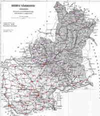
Subdivisions
In the early 20th century, the subdivisions of Bereg county were:
| Districts (járás) | |
|---|---|
| District | Capital |
| Alsóverecke | Alsóverecke, (Ukrainian: Nyzhni Vorota, Rusyn: Nyzhn'ŷ Verec'kŷ) |
| Felvidék | Ilosva, (Ukrainian: Irshava, Rusyn: Yrshava) |
| Latorca | Oroszvég, (Ukrainian: Rosvegove, Rusyn: Rosvyhovo part of Mukachevo) |
| Mezőkaszony | Mezőkaszony, (Ukrainian: Koson', Rusyn: Koson') |
| Munkács | Munkács, (Ukrainian: Mukacheve, Rusyn: Mukachovo) |
| Szolyva | Szolyva, (Ukrainian: Svaliava, Rusyn: Svaliava) |
| Tiszahát | Beregszász, (Ukrainian: Berehove, Rusyn: Berehovo) |
| Urban districts (rendezett tanácsú város) | |
| Beregszász, (Ukrainian: Berehove, Rusyn: Berehovo) | |
| Munkács, (Ukrainian: Mukacheve, Rusyn: Mukachovo) | |
All the towns mentioned are now in Ukraine.
References
- ↑ "KlimoTheca :: Könyvtár". Kt.lib.pte.hu. Retrieved 2012-06-24.
- ↑ "KlimoTheca :: Könyvtár". Kt.lib.pte.hu. Retrieved 2012-06-24.
- ↑ "KlimoTheca :: Könyvtár". Kt.lib.pte.hu. Retrieved 2012-06-24.
- ↑ "KlimoTheca :: Könyvtár". Kt.lib.pte.hu. Retrieved 2012-06-24.
