Bembridge Airport
| Bembridge Airport | |||||||||||
|---|---|---|---|---|---|---|---|---|---|---|---|
 | |||||||||||
| Summary | |||||||||||
| Airport type | Public | ||||||||||
| Operator | Vectis Gliding Club Ltd | ||||||||||
| Location | Bembridge | ||||||||||
| Elevation AMSL | 53 ft / 16 m | ||||||||||
| Coordinates | 50°40′41″N 001°06′34″W / 50.67806°N 1.10944°WCoordinates: 50°40′41″N 001°06′34″W / 50.67806°N 1.10944°W | ||||||||||
| Website | http://www.vectisglidingclub.co.uk | ||||||||||
| Map | |||||||||||
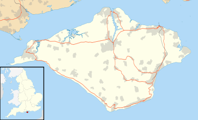 EGHJ Location on the Isle of Wight | |||||||||||
| Runways | |||||||||||
| |||||||||||
| Statistics (2007) | |||||||||||
| |||||||||||
|
Sources: Aerodrome information from Bembridge Airport[1] Statistics from the UK Civil Aviation Authority[2] | |||||||||||
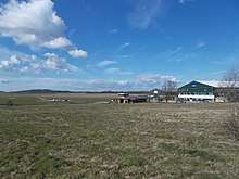
Bembridge Airport (IATA: BBP, ICAO: EGHJ) is an unlicensed aerodrome located about a mile south-west of the village of Bembridge, Isle of Wight, England. It is one of two small airstrips on the Isle of Wight, the other being Sandown Airport about four miles to the south-west.
Bembridge Aerodrome no longer has a CAA Ordinary Licence (Number P854) that allows flights for the public transport of passengers or for flying instruction as authorised by the licensee (Bembridge Airport Limited).[3]
Bembridge Airport is now open to non residents PPR (prior permission required).
Gliding no longer takes place from Bembridge .
References
External links
Isle of Wight Portal | |
| Unitary authorities | |
| Major settlements | |
| Rivers | |
| Topics | |
This article is issued from
Wikipedia.
The text is licensed under Creative Commons - Attribution - Sharealike.
Additional terms may apply for the media files.