Belvedere, London
| Belvedere | |
|---|---|
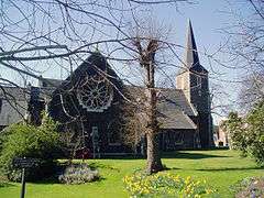 All Saints Church | |
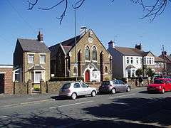 Village streetscene with the Congregational Church | |
 Belvedere Belvedere shown within Greater London | |
| Population | 11,890 (2011 Census. Ward)[1] |
| OS grid reference | TQ495785 |
| London borough | |
| Ceremonial county | Greater London |
| Region | |
| Country | England |
| Sovereign state | United Kingdom |
| Post town | BELVEDERE |
| Postcode district | DA17 |
| Dialling code |
020 [n 1] 01322 |
| Police | Metropolitan |
| Fire | London |
| Ambulance | London |
| EU Parliament | London |
| UK Parliament | |
| London Assembly | |

Belvedere /ˈbɛlvədɪər/ is a town in the London Borough of Bexley, in the historic county of Kent and ceremonial county of Greater London. It lies South of the River Thames, East of Abbey Wood and Thamesmead, West of Erith, and North of Bexleyheath.
History
The area which is today known as Belvedere was for centuries part of Lesness Heath,[2] the eastern parts of a narrow high ridge which stretches from the area of Lesnes Abbey to Erith. The northern stretch is industrial and environmental and was common meadow. In 1847 this largely uncultivated, wooded estate, almost undivided was given by operation of the will of last Lord Saye and Sele to his cousin Sir Culling Eardley, who built properties in Belvedere until his death in 1863. Eardley constructed a large wooden tower (see Belvedere (structure)) on the heath to gain views over his estate to the river Thames, giving the area its name from the Italian "beautiful view". The name can also be applied today, as the ridge of the area, and parts of its southern uplands, have commanding views towards Canary Wharf and Central London.[n 2]
Eardley was persuaded to allow the construction on his property, of a Dissenters' chapel, which was built so that the original wooden belvedere became its tower. In order that the public were able to attend this chapel, he constructed paths to it across Lesness Heath. Eardley had finished in 1861, after nearly 8 years of building, his chapel, now All Saints' Church, after the earlier chapel with belvedere burned down on the same site.[3] At the same time Eardley constructed Villa Houses and reinforced the heath path to become Erith Road. Belvedere village soon grew up along the path which became Bexley Road (from March 1939 known as Nuxley road after the small heath located 1Km south) as Eardley gradually sold off the land.
Belvedere Explosion of 1864
At about 6.40 am on Saturday the first of October 1864 there was a massive explosion which totally destroyed two commercial gunpowder factories, situated in isolation on the Belvedere side of Erith Marshes, along with their store magazines and a couple of barges that were being loaded with barrels of gunpowder at the time. The explosion was heard over a 50 miles radius, and the shock wave was so intense that people in central London were convinced that there had been an earthquake. One report at the time said that as rescuers hurried to the site they found a massive crater and absolutely no signs of any buildings were left “it was if the place had been swept clean by a broom”. Surprisingly there were only around twenty casualties, as though the explosion was huge, the remote location prevented greater loss of life.[4]
- 1900 to date
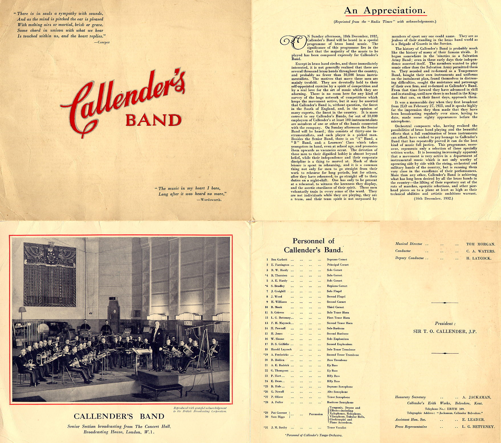
Belvedere was in Kent and formed part of the Municipal Borough of Erith before 1965 and development took place before the Second World War, with significant reconstruction after the Blitz. Despite this, Upper Belvedere and The Village still retains much of its Victorian and Edwardian charm and character. Between 1898 and 1961 Callender's Cable Works, at the Erith Works, Belvedere, was patron to Callender's Cableworks Band, an amateur brass band made up of employees of the company. The band was a prolific broadcaster on BBC Radio in the 1920s and 1930s.[5]
Flood of 1953
The North Sea Flood of 1953 hit the area of Belvedere Marshes badly, leaving the 1700 gypsies who lived there with nothing. One person died in the flooding and hundreds had their homes damaged. Queen Elizabeth II came to visit the communities of Erith and Belvedere, who were without electricity for weeks, to pay her respects.[6]
Controversy Over Name
There has been a lot of controversy with local residents over recent years about the correct name of the "village" area of Belvedere incorporating the triangle of Nuxley Road, Albert Road, and Woolwich Road. Council road signs call it Belvedere Village, maps and the post office list the area as Belvedere, but some locals call it Nuxley Village after the road. Many residents informally call the area "The Village". The origins of Nuxley Village is believed to come from estate agents upselling the area.
Subdistricts
Within the ward are:
- Erith Marshes/Crossness Nature Reserve
- Abbey Wood, Bostall Heath and Woods, Lesnes Abbey, Thamesmead, and West Heath.
Landmarks
Upper Belvedere features a fine church and some fine Victorian & Edwardian brick villas. It has a number of fine pubs, restaurants and retail outlets: The Eardley Arms and the Prince of Wales on Woolwich Road, The Victoria on Victoria Street, The Royal Standard, The Village Inn (formerly the Queens Head) and The Fox all on Nuxley road.[7] Upper Belvedere is also home to a large park and a library that was in danger of being shut down due to the government's cuts. Fortunately closure threats have been averted thanks to the efforts of the local community. A new 'Splash Park' (opened in 2005, closed in 2016) was a welcomed addition to the village, having been developed on the site of the old Victorian paddling pool. The splash park retained some of the original paddling pool structures. The Splash Park was closed in 2016 and replaced with a new play area called Belvedere Beach, this opened to the public on the 27th of July 2017.
Lower Belvedere is smaller and more industrial and has a Methodist chapel, a Sikh Temple and borders to its north the high technology sludge, methane incinerator, a small industrial park, large waste incinerator and Joseph Bazalgette's Crossness Sewage Treatment Works and is closer to the railway station than Upper Belvedere. Lower Belvedere is also the location of the Belvedere Community Forum,[8] which runs and meets at Belvedere Community Centre.[9]
The Grade II Listed Bexley College was designed in 1906 by W Egerton in the Queen Anne style and is on residential Erith Road on the last part of the ridge, in the east of the district on the border of Erith.[10]
The Woolwich Road Conservation Area was designation in February 1992, by Bexley Council due to its special Victorian character and high concentration of historical buildings in a small area. The conservation area includes the Eardley Arms public house, Prince of Wales public house, DVLA Driving Test Centre (the original Belvedere Police Station built in the 1880s), Belvedere Recreation Grounds and the large residential villas and semi detached houses along Woolwich Road and Gloucester Road. These houses were for the wealthier Victorian families of the area, possibly for the professional classes or for the managers or owners of the businesses which located in Erith and Woolwich.[11] The former Woolwich Road police station was built in 1881 at a cost of £3386 and designed to blend in with the adjacent houses. Belvedere at that time had a strength of two inspectors, three sergeants, and twenty six constables. It remained an active police station until 1968, when the present station was built on the corner of Nuxley Road and Woolwich Road.[12]
Places of worship
- All Saints Belvedere, Nuxley Road
- Free Grace Baptist Church, Nuxley Road, Belvedere
- Belvedere Congregational Church, Picardy Road
- Belvedere Baptist Church
- Belvedere Methodist Church
- St Augustine, Belvedere
- Ichthus Community Church, Belvedere
- Belvedere Pentecostal, Mitchell Close
- Guru Nanak Darbar, Sikh Temple, Mitchell Close
Demography
As of the 2011 census, 65% of the population is White British, followed by 12% Black African.[13]
Politics
Councillors for the Belvedere Ward of Bexley London Borough Council are Daniel Francis (Labour), Gill MacDonald (Labour) and Seán Newman (Labour). Belvedere lies within the Erith and Thamesmead constituency (MP Teresa Pearce, Labour), and is in the Bexley and Bromley London Assembly constituency, represented by James Cleverly (Conservative).
Education
- For education in Belvedere, London see the main London Borough of Bexley article
Sport
Erith and Belvedere Football Club recently moved to Welling in a ground-sharing arrangement. Belvedere Football Club play at Memorial Sports Ground, Woolwich Road, Abbey Wood and compete in the Kent County League Division One (West).
Bexleyheath and Belvedere Hockey Club are based in Welling, but play some home matches at Erith School.[14]
Transport
Rail
Belvedere railway station, opened in 1859, is in Lower Belvedere and is served by the North Kent Line which runs from London Cannon Street to Dartford/Gravesend/Gillingham (Kent). Belvedere also benefits from the DLR connection at nearby Woolwich, and will benefit further with the arrival of the long-awaited 'Crossrail' extension in neighbouring Abbey Wood in 2019.
Buses
Belvedere is served by several Transport for London Bus services connecting it with areas including Thamesmead, Erith, Bexleyheath, Woolwich and Sidcup.
Green Chain Walk
The Green Chain Walk is largely east-west route along the northern slopes of the ridge, stretching from Plumstead Common to Erith, it provides a shortcut to the Thames Path - to which it is linked in three locations.
Motoring
Driving test statistics from the DVSA for the year 2013-14 showed that Belvedere test centre had the lowest pass rate in Great Britain.[15]
The proposed Belvedere Crossing across the River Thames would be either a bridge or tunnel between Belvedere and Rainham.[16]
Geography
Belvedere borders the River Thames to the north, Erith to the north east and east, Northumberland Heath to the south east and south, West Heath to the south west, Abbey Wood to the west and Thamesmead to the north west.
Notable residents
- Billy Cornelius (b. 1898), professional football player and manager, born in Belvedere[17]
- Alec Debnam (1921–2003), cricketer, born in Belvedere[18]
- Walter Donaldson (1907–73), Scottish snooker player, lived for some years in Grosvenor Road[19]
- Roy Dwight (1933–2002), footballer (Nottingham Forest), born in Belvedere[20]
- Mike Kelly (b. 1954), footballer (Millwall FC), born in Belvedere[21]
- Alan Knott (b. 1946), cricketer, born in Belvedere, attended Northumberland Heath Secondary Modern School[22]
- Colin Seeley (b. 1938), champion motorcyclist and motorbike designer, lived in Belvedere and worked on Nuxley Road[23]
- Flaxman Charles John Spurrell (1842–1915), archaeologist, geologist and photographer, lived at The Priory, Picardy Road[24]
- Anne Swithinbank (b. 1957), horticulturist and gardening writer, born in Belvedere
See also
Notes and references
- Notes
- References
- ↑ "Bexley Ward population 2011". Neighbourhood Statistics. Office for National Statistics. Retrieved 14 October 2016.
- ↑ Samuel Lewis, ed. (1848). "Lenham - Levens". A Topographical Dictionary of England. Institute of Historical Research. Retrieved 20 June 2013.
- ↑ All Saints' Church - Grade II Historic England. "Details from listed building database (1064197)". National Heritage List for England. Retrieved 20 June 2013.
- ↑ "Erith Fun Day". arthurpewtysmaggotsandwich.blogspot.co.uk. Retrieved 2017-11-12.
- ↑ Callender's Band performance programme or handout leaflet, 16 Dec 1932
- ↑ Cottle, Robin. "Remembering the Belvedere floods, 60 years on". Bexley Times. Retrieved 2017-10-28.
- ↑ Erroneously called by some 'Nuxley Village' because the main road is 'Nuxley Road'. Nuxley was the name of a small heath that used to exist some 1Km south of the village, which was cleared in the 1815 land enclosure act, the road takes its name from this.
- ↑ London Borough of Bexley, Bexley Civic Offices (9 February 2012). "Belvedere Community Forum".
- ↑ "belvederecommunitycentre.org.uk".
- ↑ "Bexley College (Former Erith Technical Institute) Including Attached Walls Railings and Gatepiers, Bexley". www.britishlistedbuildings.co.uk. Retrieved 22 December 2013.
- ↑ Council, Bexley (June 2008). "Woolwich Road Conservation Area Appraisal And Management Plan" (PDF). www.bexley.gov.uk.
- ↑ "Erith and Belvedere Local History Society". January 2015.
- ↑ Services, Good Stuff IT. "Belvedere - UK Census Data 2011".
- ↑ "BBHC Hockey Club". Archived from the original on 31 October 2012. Retrieved 16 March 2013.
- ↑ Lumb, David (2015-06-01). "Where's the toughest UK driving test?". BBC News. Retrieved 2015-06-01.
- ↑ "Have your say on new river crossings in east and southeast London". Transport for London.
- ↑ Lafranchi, Pierre (2001). Moving with the Ball: The Migration of Professional Footballers. Berg Publishers. p. 52. ISBN 1-85973-302-6.
- ↑ "Alec Debnam". cricketarchive.com. Retrieved 25 November 2016.
- ↑ "Surnames beginning with D". bexley.gov.uk. Retrieved 9 December 2016.
- ↑ "Nottingham Forest at 150: Flashback: Goal-hero Dwight watches rest of final from hospital". Nottingham Post. 24 November 2015. Retrieved 25 November 2016.
- ↑ "Millwall Players E-L". millwall-history.org.uk. Retrieved 25 November 2016.
- ↑ "Alan Knott | England Cricket | Cricket Players and Officials | ESPN Cricinfo". Cricinfo.com. Retrieved 2015-04-27.
- ↑ "Surnames beginning with S". bexley.gov.uk. Archived from the original on 20 December 2016. Retrieved 9 December 2016.
- ↑ F. C. J. Spurrell, Kentish Antiquary and Archaeologist, Nesta D. Caiger
External links
- www.belvedereuk.info - A comprehensive local history site being developed
- Belvedere Football Club
- Lesnes Abbey Conservation Volunteers (LACV)
