Belonia, India
| Belonia | |
|---|---|
| City | |
 Belonia  Belonia | |
| Coordinates: 23°15′N 91°27′E / 23.25°N 91.45°ECoordinates: 23°15′N 91°27′E / 23.25°N 91.45°E | |
| Country | India |
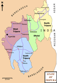
| State | Tripura |
| District | South Tripura |
| Area rank | 2 |
| Elevation | 23 m (75 ft) |
| Population (2015) | |
| • Total | 21,176 |
| Languages | |
| • Official | |
| Time zone | UTC+5:30 (IST) |
| Pin | 799155 |
| Telephone code | 03823 |
| Vehicle registration | TR 08 |
| Website |
tripura |
Belonia is a town and Municipal Council in South Tripura district, Tripura, India. It is also the headquarters of South Tripura District. It is linked with Agartala (the state capital) by National Highway 8 via Udaipur and also via Rajnagar, Sonamura, Melaghar, and Bishramganj. Belonia lies on a border with Bangladesh.
Geography
Belonia is located at 23°15′N 91°27′E / 23.25°N 91.45°E.[1] It has an average elevation of 23 metres (75 feet).
Demographics
As of 2011 India census,[2] Belonia Municipal Council has a population of 19,996. Mrs. Subhra Mitra is the present Chairperson of Belonia Municipal Council. Males constitute 52% of the population and females 48%. Belonia has an average literacy rate of 95%, higher than the national average of 59.5%; with 54% of the males and 46% of females literate. 9% of the population is under 6 years of age.
Education
Schools:
- Belonia Vidyapith H/S School
- Brajendra Kishore Institution
- Aryya Colony H/S School
- S.B.C Nagar H/S School
- Barpathari H/S School
- Brindaban Royaja Para High School, Chittamara, Belonia
- Manurmukh High School
- Amjadnagar High School
- Belonia Govt. English Medium H.S. School
- Belonia Girls H.S. School
- Satmura S.B School
- Ganoyday S.B School
- South Mirzapur High School
Colleges:
- Iswar Chandra Vidyasagar College
- ITI College
Places of interest

- Pilak-Pathar, 12th century Hindu-Buddhist archaeological site preserved by ASI, about 12 kilometres (7.5 mi) away
- Trishna Wildlife Sanctuary
- Yogmaya Temple, Kalibari
- Indo-Bangla Custom Checkpost
- Raj Rajeswari Temple, Muhuripur
- Muhurichar river island
- Muhuripur Fishery near Bamchara
Proposed railway station
A railway station is proposed to be constructed in Belonia (code: BLNIA) to serve the town.[3] The station lies on the Agartala - Sabroom rail section, which comes under the Lumding railway division of the Northeast Frontier Railway. The segment from Agartala to Sabroom via Udaipur may become operational in 2020, with a proposed elevation of 39m.[4][5]
Integrated Check Post (ICP)
Railway station here at border of India will have Integrated Check Post for immigration and customs and will connect Indian railway network 120 km away with Chittagong port in Bangladesh via Feni.
Politics
Belonia assembly constituency is in the Tripura West Lok Sabha constituency.[6]
See also
References
- ↑ Falling Rain Genomics, Inc - Belonia
- ↑ "Census of India 2001: Data from the 2001 Census, including cities, villages and towns (Provisional)". Census Commission of India. Archived from the original on 2004-06-16. Retrieved 2008-11-01.
- ↑ "BLNIA/Belonia Railway Station Map/Atlas NFR/Northeast Frontier Zone - Railway Enquiry". indiarailinfo.com. Retrieved 2017-03-21.
- ↑ IANS (22 February 2016). "First Commercial Broad Guage [sic] Freight Train Arrives In Tripura". NDTV. Retrieved 19 July 2018.
- ↑ "TRIPURAINFO : The first news, views & information website of TRIPURA". 2016-03-21. Archived from the original on 2016-03-21. Retrieved 2017-03-21.
- ↑ "Assembly Constituencies - Corresponding Districts and Parliamentary Constituencies" (PDF). Tripura. Election Commission of India. Archived from the original (PDF) on 8 November 2005. Retrieved 2008-10-08.