Sabroom
| Sabroom | |
|---|---|
| city | |
 Sabroom  Sabroom | |
| Coordinates: 23°00′N 91°44′E / 23.00°N 91.73°ECoordinates: 23°00′N 91°44′E / 23.00°N 91.73°E | |
| Country | India |
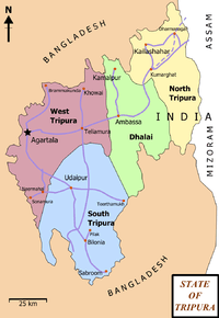
| State | Tripura |
| District | South Tripura |
| Elevation | 26 m (85 ft) |
| Population (2001) | |
| • Total | 5,766 |
| Languages | |
| • Official | Bengali, Kokborok, English |
| Time zone | UTC+5:30 (IST) |
| Vehicle registration | TR |
| Website |
tripura |
Sabroom (also spelt as Sabrum) is a town and a nagar panchayat in South Tripura district in the Indian state of Tripura.
Sabroom is located in the banks of the Feni river, which separates India and Bangladesh. Most of the people speak in Noyakhali, a dialect of Bengali Language.
Geography
Sabroom is located at 23°00′N 91°44′E / 23.00°N 91.73°E.[1] It has an average elevation of 26 m (85 ft).
Demographics
As of 2001 India census,[2] Sabroom had a population of 5766. Males constitute 52% of the population and females 48%. Sabroom has an average literacy rate of 82%, higher than the national average of 59.5%: male literacy is 86%, and female literacy is 78%. In Sabroom, 11% of the population is under 6 years of age.
Politics
Sabroom assembly constituency is part of Tripura East (Lok Sabha constituency).[3]
See also
References
- ↑ Falling Rain Genomics, Inc - Sabroom
- ↑ "Census of India 2001: Data from the 2001 Census, including cities, villages and towns (Provisional)". Census Commission of India. Archived from the original on 2004-06-16. Retrieved 2008-11-01.
- ↑ "Assembly Constituencies - Corresponding Districts and Parliamentary Constituencies" (PDF). Tripura. Election Commission of India. Archived from the original (PDF) on 2005-11-08. Retrieved 2008-10-08.