Bega (Tisza)
| Bega Begej / Бегеј | |
| River | |
 | |
| Countries | Romania, Serbia |
|---|---|
| Tributaries | |
| - left | Bega Luncanilor, Gladna, Bega Veche |
| - right | Bega Poieni, Chizdia |
| Towns | Romania: Făget, Recaș, Timișoara Serbia: Zrenjanin, Ečka |
| Source | |
| - location | Poiana Ruscă Mountains Confluence of headwaters Bega Luncanilor and Bega Poieni, Romania |
| Mouth | Tisa river near Titel, Serbia |
| - coordinates | 45°12′30″N 20°18′55″E / 45.20833°N 20.31528°ECoordinates: 45°12′30″N 20°18′55″E / 45.20833°N 20.31528°E |
| Length | 244[1] km (152 mi) |
| Basin | 4,458 km2 (1,721 sq mi) |
| Progression | Tisza→ Danube→ Black Sea |
The Bega (Romanian: Bega, Serbian: Begej (Бегеј), German: Bega, Hungarian: Béga) is a 244 km long river in Romania (169 km) and Serbia (75 km).[1] It rises in the Poiana Ruscă Mountains in Romania, part of the Carpathian Mountains, and it flows into the Tisa river near Titel, Vojvodina, Serbia. Its drainage basin covers an area of 4,458 km2 (1,721 sq mi),[2]:22 of which 2,362 km2 (912 sq mi) in Romania.[3]
Course
Romania
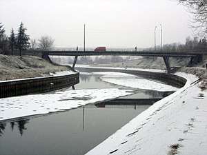
The river starts at the confluence of its headwaters Bega Luncanilor and Bega Poieni. After flowing north, the river bends to the west at Curtea, passing through Făget, Balinț, and Topolovățu Mare, where it enters the low Banat plains. There, it begins to spill over, so the Bega canal was constructed tracking Bega Veche, which is also channelled for 97 km, as a parallel waterway for 114 km, before the two rejoin northeast of Zrenjanin, Serbia. The Bega canal runs through Timișoara and continues to the southwest, enters Serbia near the village of Hetin.
Serbia
Near Jankov Most, the Begej becomes part of the large canal Danube-Tisa-Danube (or DTD) and turns south, receiving waters from the Novi Begej. There it is separated from DTD route turning west and reaching Zrenjanin. From there it continues to the south, using the old river bed of the Tisa, passing through Ečka, Stajićevo and Perlez. In this part, it flows through marshlands, some of which are transformed into the Ečka fish pond (Serbian: Ribnjak Ečka, Рибњак Ечка), the largest one in Serbia with an area of 25 km². The remaining parts of wetland make the largest swamp in Serbia, Carska bara (Cyrillic: Царска бара; Imperial marsh, 11 km²), after which Begej empties into the Tisa.
Characteristics
Through the Tisa and Danube rivers, it belongs to the Black Sea catchment basin. Its own catchment area is 2,878 km².
The channelled parts of both Stari Begej and Novi Begej in Serbia were navigable, but due to the lack of proper maintenance, the Begej proper (Stari Begej) stopped being navigable in the 1950s. In August 2018 the project of a massive revitalization of the river was announced as a joint venture of Serbia, Romania and European Union. The project will include the transformation of the river into a navigable one again, all the way to the Romanian border. It also includes a reconstruction of the locks at Srpski Itebej and Klek, revitalization of a port and an anchorage in Zrenjanin and a bicycle path along the river, from Zrenjanin to the Romanian border. It is planned that the entire project will be finished in 4 years, by 2022.[4]
Settlements on Novi Begej include the villages of Srpski Itebej (with a huge fishpond), Novi Itebej, Torak (formerly Begejci) and Žitište.
Tributaries
The following rivers are tributaries to the river Bega (in downstream order):
Left: Bega Luncanilor (Bega Mare), Pârâul Carpenului, Șopot, Vădana, Bucovăț, Zopana, Bălășina, Gladna, Timișel, Glavița
Right: Bega Poieni (Bega Mică), Homojdia, Năndrăneasca, Icui, Zidileasca, Bunea, Cladova, Nieregiș, Fădimac, Miniș, Chizdia, Temeșiț, Mociur, Valea Țiganului, Gherteamoș, Potoc-Remetea, Behela, Bega Veche
Part of the water from the river Timiș is diverted towards the Bega by the Coșteiu-Chizătău Canal.
Settlements located near the river
Romania
In downstream order: Margina, Făget, Răchita, Mănăștiur, Leucușești, Bethausen, Cutina, Bodo, Balinț, Chizătău, Ictar-Budinț, Topolovățu Mic, Recaș, Remetea Mare, Ghiroda, Timișoara, Utvin, Sânmihaiu Român, Uivar, Otelec
Serbia
In downstream order: Hetin, Srpski Itebej, Novi Itebej, Torak, Žitište, Banatski Dvor, Jankov Most, Klek, Zrenjanin, Ečka, Lukino Selo, Stajićevo, Perlez, Titel
See also
References
- 1 2 Statistical Yearbook of the Republic of Serbia 2017 (PDF) (in Serbian and English). Belgrade: Statistical Office of the Republic of Serbia. October 2017. p. 16. ISSN 0354-4206. Retrieved 30 May 2018.
- ↑ Analysis of the Tisza River Basin 2007, IPCDR
- ↑ Daniel Celu Vîrdol and Tudorel Andrei (eds.), Anuarul Statistic al României 2017 Romanian Statistical Yearbook (Bucharest: Institutul Național de Statistică, 2018), p. 13.
- ↑ S.K. (7 August 2018). "Биће Бегеј опет плован" [Begej will be navigable again]. Politika (in Serbian).
- Mala Prosvetina Enciklopedija, Third edition (1985); Prosveta; ISBN 86-07-00001-2
- Jovan Đ. Marković (1990): Enciklopedijski geografski leksikon Jugoslavije; Svjetlost-Sarajevo; ISBN 86-01-02651-6
- Administrația Națională Apele Române – Cadastrul Apelor – Bucharest
- Institutul de Meteorologie și Hidrologie – Rîurile României – Bucharest, 1971
- ICPA – Comune vulnerabile – Județul Timiș
- Trasee turistice – județul Timiș
Maps
Images
| Wikimedia Commons has media related to Bega/Begej. |
 The Bega near Ečka
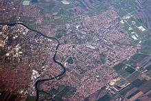
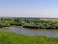 The mouth of the Bega into the Tisa, across Titel