Beersheba metropolitan area
| Largest city | Beersheba |
| Other cities | Rahat |
| Population | Ranked 4th in Israel |
| - Total | 377,100 (2016 est.) |
| - Density | 556.8/km2 |
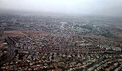
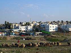
The Metropolitan area of Beersheba (Hebrew: מטרופולין באר שבע) is a metropolitan area including areas from both the Beersheba and the Southern Districts of Israel. The area is closely linked to the city of Beersheba through social, economic, and cultural ties. The metropolitan area of Beersheba is located in the Negev desert. The Beersheba metropolitan area is the fourth largest metropolitan area in the country, with an estimated population of over 377,100.
Metropolitan rings
Israel Central Bureau of Statistics divides the Beersheba metropolitan area into two areas:
| Metropolitan ring | Localities | Population (2016 estimate) | Population density (per km²) |
Annual Population growth rate | |||
|---|---|---|---|---|---|---|---|
| Total | Jews and others1 | Thereof: Jews | Arabs | ||||
| Core2 | 1 | 205,800 | 200,800 | 180,300 | 5,000 | 1,752 | 1.1% |
| Outer Ring3 | 32 | 171,300 | 38,300 | 37,700 | 133,000 | 306 | 3.4% |
| Northern Section | 12 | 90,000 | 12,700 | 12,400 | 77,300 | 292 | 3.4% |
| Eastern Section | 8 | 71,500 | 15,800 | 15,500 | 55,800 | 562.3 | 3.5% |
| Western Section | 12 | 9,800 | 9,800 | 9,700 | 0 | 78.6 | 3.6% |
| Total | 33 | 377,100 | 239,000 | 217,900 | 138,100 | 556.8 | 2.1% |
Notes
Transportation
Transit
Rail service connects the Beersheba metropolitan area with Ashkelon, Tel Aviv and Haifa. Bus service connects to Eilat, Ashkelon, Tel Aviv, Haifa, and Jerusalem.
Major highways
The major highways in the Beersheba metropolitan area include Area are:
See also
References
- ↑ "Localities, Population and Density per sq. km. by Metropolitan Area, Rings and Sections, 2016" (PDF). CBS. Retrieved 2018-01-09.
| Cities | ||
|---|---|---|
| Local councils | ||
| Regional councils | ||
| See also | ||
| ||
Coordinates: 31°14′59.15″N 34°47′59.07″E / 31.2497639°N 34.7997417°E