Beaver Meadows, Pennsylvania
| Beaver Meadows, Pennsylvania | |
|---|---|
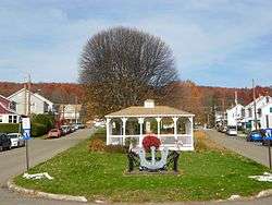 Gazebo on Church St. | |
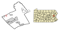 Location of Beaver Meadows in Carbon County, Pennsylvania. | |
 Beaver Meadows Location of Beaver Meadows in Pennsylvania  Beaver Meadows Beaver Meadows (the US) | |
| Coordinates: 40°55′42″N 75°54′46″W / 40.92833°N 75.91278°WCoordinates: 40°55′42″N 75°54′46″W / 40.92833°N 75.91278°W | |
| Country | United States |
| State | Pennsylvania |
| County | Carbon |
| Area[1] | |
| • Total | 0.26 sq mi (0.67 km2) |
| • Land | 0.26 sq mi (0.67 km2) |
| • Water | 0.00 sq mi (0.00 km2) |
| Elevation[2] | 1,598 ft (487 m) |
| Population (2010) | |
| • Total | 869 |
| • Estimate (2016)[3] | 836 |
| • Density | 3,240.31/sq mi (1,250.34/km2) |
| Time zone | UTC-5 (EST) |
| • Summer (DST) | UTC-4 (EDT) |
| ZIP code | 18216 |
| Area code(s) | 570 |
| FIPS code | 42-04816 |
Beaver Meadows is a borough in Carbon County, Pennsylvania, United States. The population was 869 at the 2010 census.[4]
Geography
Beaver Meadows is located in northwestern Carbon County at 40°55′42″N 75°54′46″W / 40.92833°N 75.91278°W (40.928438, -75.912787) along Beaver Creek,[5] amidst a historic transportation corridor dating back to Amerindian Trails through the wilderness area known to the Amerindians as "The Great Swamp". The Great Swamp was part of a vastly greater wilderness once known as “St. Anthony’s Wilderness” and by the Amerindians, the “Towamensing” being an Indian word for “wilderness”— a vast pinewood forest and boggy swamp-plagued valleys well watered by diverse springs and mountain creeks such as Quakake Creek, Beaver Creek, Hazel Creek and a host of others coming off the slopes of the enclosing mountains. The Amerindians applied the term, “Towamensing” to the entire frontier area above the Blue Mountain Ridge, which while a valued hunting territory was considered less favorable to Indian settlements.
Beaver Meadow is situated at an elevation of 1,598 feet (487 m) above sea level in the valley of Beaver Creek, north of Spring Mountain, part of the Ridge-and-Valley Appalachians. According to the United States Census Bureau, the borough has a total area of 0.26 square miles (0.67 km2), all of it land.[4]
In 1752, the lands of Carbon County and Beaver Meadows area were part of Northampton County, one of the three original counties of Pennsylvania, a county as big as New Jersey.[6] the 1790s the Warrior's Path was widened into a mule and cart road some called the Lausanne-Nescopeck Road as Moravians increased their connections with the St. John's settlement in the Nescopeck Creek valley. In 1804 business interests desiring to ship timber to energy starving cities raised money for a wagon road that could support timber sledges in winter snow covers, and the Lehigh and Susquehanna Turnpike was chartered, which is now closely followed by Pennsylvania Route 93 as it passes through the borough from over Broad Mountain at Nesquehoning, leading northwest 4 miles (6 km) to Hazleton and southeast 9 miles (14 km) to U.S. Route 209 in Nesquehoning. Weatherly is 4 miles (6 km) to the east via Spring Mountain Road, where Beaver Creek ends in confluence with Hazel Creek begating Black Creek.
In 17??, Lausanne was created to provide local government for what is essentially all of Carbon County today: the eventual townships of East Penn, Lausanne, Mahoning, Banks, Towamensing, Lower Towamensing and Penn Forest;[6] Pennsylvania townships being the most rural of organized municipal governments under the commonwealth constitution. In 1826 Mauch Chunk and other townships were split out of Lausanne and the center of that township was moved northwards. In 1843 Banks Township was organized, and incorporated the small settlement of Beaver Meadows within its larger girth.[6]
History
The town of Beaver Meadows started out as a recognizable and describable 'landmark' — a meadow where beaver dams dotted the landscape — along a well known Amerindian Trail, known as the "Warriors' Path",[7] and later as well known as the trail used by Moravian Missionaries traveling between Berwick and Bethlehem, then became known as a toll gate/rest stop along the Lehigh and Susquehanna Turnpike, a bridle trail and wagon road chartered in 1804 from Jean's Run near the mouth of Nesquehoning Creek on the Lehigh River in the hamlet and township of Lausanne about nine miles south on the other side of Broad Mountain. In the 1790s a large tract of land was registered in the name of tbdl and a few farm houses dotted the valley until in 1812, anthracite coal was discovered in the vicinity of Junedale,[7] a bedroom suburb neighborhood a 1.33 miles (2.14 km)[8] west of Beaver Meadows proper.
In 1812, the secrets of burning anthracite were mostly still yet to be discovered, revealed, and promoted (widely publicized) by Josiah White and Erskine Hazard but blacksmiths were several decades into knowing how to use it as an auxiliary fuel to compliment bituminous or charcoal in forge fires, so by 1813 a modest pit mine was opened up to ship coal northwest to smithies of Berwick and Bloomington. The first house of the town was built in 1804 of logs. The first houses were built along the main thoroughfare, today's Broad Street east of the junction between Berwick St. (the continuation of the turnpike and Rt-93 to Hazelton) and Main St. westwards to Junedale, Tresckow, and Tamaqua.
Nathan Beach discovered coal in 1812, and opened a 'quarry' (pit mine) in 1813,[6] shipping his coal initially west by wagon to Berwick and Bloomsburg over the Berwick-Nescopeck Toll Bridge. With road improvements, he was able to ship his coal to Lausanne Landing where arks were being built by the Lehigh Coal Mine Company and coal could sporadically make it to Philadelphia. In 1817, stymied by the slow movements of the Schuylkill Canal board of directors, White and Hazard began the improvements making the one-way Lehigh Navigations in 1818, and travel Lehigh River downstream grew steadily safer. By the end of 1820 the new Lehigh Canal, as yet rough and unfinished, nonetheless enabled a record 365 long-tons to be shipped to Philadelphia and glut the cities docks. By 1823 steady shipments allowed self-funding and the canal was being re-engineered and a gradual conversion begun into a system with two way locks; it success in providing the suddenly available and affordable clean fuel to assuage the nation's on going energy crisis, the Erie Canal opening, followed by the news of railroad events in Britain in 1825 began whole chains of events spurring industrial production and railroads.[9]
In 1826 a Colonel William H. Wilson moved to the town and built a tavern. In 1831, James Lamison became citizen No. 3 and also opened a tavern.[6] By that time the Beaver Meadow Railroad and Coal Company had been formed and was subscribing stock. It was chartered on April 13, 1830, and the industrial revolution was about to begin using Beaver Meadows as a center. The company Building down the valleys from Beaver and Black Creeks, the tributaries dumped into the Lehigh below and near Penn Haven Junction where the railroad expected to ship to the Lehigh Canal. At the time, the Room Run Railroad was occupying space assumed free by the Beaver Meadows planners assumptions, for in 1830 operating managers Josiah White & Erskine Hazard of the Lehigh Coal & Navigation Company (LC&N Co.) were opening new mines (freed now of immediate or further improvement needs of the Lehigh Canal or the Summit Hill and Mauch Chunk Railroad) in the area of what is now Nesquehoning and building a two-mile funicular railway called the Room Run or Rhume Run Railroad to increase volume shipped by the company. Hence the two railroads were to contend for the same space. At one point both companies put armed men into the field, but an amicable settlement was reached but for a rate dispute to break out. This resulted in a resolve to build the railroad all the way to Easton, but a deal was reached after the railroad reached past Mauch Chunk to Parryville, Pennsylvania, where auxiliary barge loading facilities were built.
The earliest settlement in Banks township [of 1886] was made in that portion which was in 1897 set off to form the borough of Beaver Meadow. The township was contained within the territory of Lausanne until January, 1842, when it was separately organized, being named in honor of Judge Banks, then on the bench of Northampton county, of which Carbon formed a part until 1843.
— Brenckman, History of Carbon County, Chapter XIII. 1884, 1913 ed.
The Beaver Meadow Railroad & Coal Company bought 200 acres (81 ha) and subcontracted coal operations to A.H. VanCleve and Co. opening their own mines. By 1833 they began local operations and construction of the railway along the surveyed right of way. Getting strong-armed by LC&N Co., the company got a change in charter and continued downstream along the Lehigh until LC&N Co. blinked and granted acceptable shipping rate terms.[7] In 1835 they contracted for the first wood burning steam locomotives to operate in Northampton and Carbon counties, which began operations in 1836. They'd also demonstrated a railroad could be built over 30 miles through mountainous country. The Beaver Meadow Railroad became an operational success, and an inspiration. In 1846 some investors began the “Delaware, Lehigh, Schuylkill and Susquehanna Railroad Company” with the grandiose scheme of linking New York Harbor at Jersey City via New Jersey to the Susquehanna and then the great lakes via a line across the Delaware and up the Lehigh. Eventually, they succeeded, for this was the start of the Lehigh Valley Railroad, whose oldest parts were the Beaver Meadows Railroad, it absorbed in 1866.
Demographics
| Historical population | |||
|---|---|---|---|
| Census | Pop. | %± | |
| 1880 | 502 | — | |
| 1900 | 1,378 | — | |
| 1910 | 1,530 | 11.0% | |
| 1920 | 1,709 | 11.7% | |
| 1930 | 1,890 | 10.6% | |
| 1940 | 2,030 | 7.4% | |
| 1950 | 1,723 | −15.1% | |
| 1960 | 1,392 | −19.2% | |
| 1970 | 1,274 | −8.5% | |
| 1980 | 1,078 | −15.4% | |
| 1990 | 985 | −8.6% | |
| 2000 | 968 | −1.7% | |
| 2010 | 869 | −10.2% | |
| Est. 2016 | 836 | [3] | −3.8% |
| Sources:[10][11][12] | |||
As of the census[11] of 2000, there were 968 people, 404 households, and 258 families residing in the borough. The population density was 3,746.4 people per square mile (1,437.5/km²). There were 458 housing units at an average density of 1,772.6 per square mile (680.1/km²). The racial makeup of the borough was 99.38% White, 0.10% Native American, 0.21% Asian, 0.21% from other races, and 0.10% from two or more races. Hispanic or Latino of any race were 1.24% of the population.
There were 404 households, out of which 24.8% had children under the age of 18 living with them, 46.0% were married couples living together, 10.4% had a female householder with no husband present, and 36.1% were non-families. 33.2% of all households were made up of individuals, and 17.1% had someone living alone who was 65 years of age or older. The average household size was 2.39 and the average family size was 3.04.
In the borough the population was spread out, with 22.3% under the age of 18, 6.6% from 18 to 24, 28.8% from 25 to 44, 20.0% from 45 to 64, and 22.2% who were 65 years of age or older. The median age was 40 years. For every 100 females there were 100.4 males. For every 100 females age 18 and over, there were 102.7 males.
The median income for a household in the borough was $31,058, and the median income for a family was $42,500. Males had a median income of $30,000 versus $20,417 for females. The per capita income for the borough was $17,296. About 4.4% of families and 7.6% of the population were below the poverty line, including 6.0% of those under age 18 and 15.6% of those age 65 or over.
Notable people
- Norm Larker, Major League Baseball player from 1958 to 1963. He died in Long Beach, California at the age of 76.
References
- ↑ "2016 U.S. Gazetteer Files". United States Census Bureau. Retrieved Aug 13, 2017.
- ↑ "Borough of Beaver Meadows". Geographic Names Information System. United States Geological Survey. August 2, 1979. Retrieved 2008-02-05.
- 1 2 "Population and Housing Unit Estimates". Retrieved June 9, 2017.
- 1 2 "Geographic Identifiers: 2010 Demographic Profile Data (G001): Beaver Meadows borough, Pennsylvania". U.S. Census Bureau, American Factfinder. Retrieved April 1, 2015.
- ↑ "US Gazetteer files: 2010, 2000, and 1990". United States Census Bureau. 2011-02-12. Retrieved 2011-04-23.
- 1 2 3 4 5 Hazleton, PA Plain Speaker, Fri., Sept. 3, 1937 "History of Beaver Meadow, Carbon Co., Pa"Speaker Timeline
- 1 2 3 Fred Brenckman, Official Commonwealth Historian (1884). HISTORY OF CARBON COUNTY PENNSYLVANIA (2nd (1913) ed.). Also Containing a Separate Account of the Several Boroughs and Townships in the County, J. Nungesser, Harrisburg, PA Archive.org project 1913 edition, pdf e-reprint.
- ↑ Ruler tool measurement, GoogleMaps
- ↑ See for example, the Main Line of Public Works with ambitions to link Philadelphia by canal to Pittsburgh and Lake Erie!
- ↑ "Census of Population and Housing". U.S. Census Bureau. Archived from the original on 12 May 2015. Retrieved 11 December 2013.
- 1 2 "American FactFinder". United States Census Bureau. Archived from the original on 2013-09-11. Retrieved 2008-01-31.
- ↑ "Incorporated Places and Minor Civil Divisions Datasets: Subcounty Resident Population Estimates: April 1, 2010 to July 1, 2012". Population Estimates. U.S. Census Bureau. Archived from the original on 17 June 2013. Retrieved 11 December 2013.
Municipalities and communities of Carbon County, Pennsylvania, United States | ||
|---|---|---|
| Boroughs | 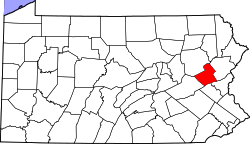 | |
| Townships | ||
| CDPs | ||
| Unincorporated communities | ||
| Footnotes | ‡This populated place also has portions in an adjacent county or counties | |