Audenried, Pennsylvania
| Audenried, Pennsylvania | |
|---|---|
| Unincorporated community | |
 Audenried  Audenried | |
| Coordinates: 40°54′38″N 75°59′30″W / 40.91056°N 75.99167°WCoordinates: 40°54′38″N 75°59′30″W / 40.91056°N 75.99167°W | |
| Country | United States |
| State | Pennsylvania |
| County | Carbon |
| Township | Banks |
| Elevation | 1,716 ft (523 m) |
| Time zone | UTC-5 (Eastern (EST)) |
| • Summer (DST) | UTC-4 (EDT) |
| ZIP codes | 18201, 18216 |
| Area code(s) | 570 and 272 |
| GNIS feature ID | 1168502[1] |
Audenried is a village in the northwest corner of Carbon County, Pennsylvania located on Route 309. It is located in Banks Township between Hazleton and McAdoo and is split between the Hazleton ZIP code of 18201 and the Beaver Meadows ZIP code of 18216. It is served by the Hazleton Area School District. The Catawissa Creek starts in Audenried and flows westward to the Susquehanna River. The remainder of Carbon County is in the Delaware watershed.
Places adjacent to Audenried, Pennsylvania | |
|---|---|
Municipalities and communities of Carbon County, Pennsylvania, United States | ||
|---|---|---|
| Boroughs | 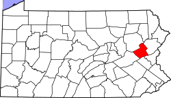 | |
| Townships | ||
| CDPs | ||
| Unincorporated communities | ||
| Footnotes | ‡This populated place also has portions in an adjacent county or counties | |
References
This article is issued from
Wikipedia.
The text is licensed under Creative Commons - Attribution - Sharealike.
Additional terms may apply for the media files.