Beaver Creek (Camas Creek)
| Beaver Creek | |
| Country | United States |
|---|---|
| State | Idaho |
| Counties | Clark County, Idaho, Jefferson County, Idaho |
| Source | |
| - location | near Monida Pass, Clark County, Idaho |
| - elevation | 7,367 ft (2,245 m) [1] |
| - coordinates | 44°30′23″N 112°21′26″W / 44.50639°N 112.35722°W [2] |
| Mouth | Camas Creek |
| - location | north of Hamer, Jefferson County, Idaho |
| - elevation | 4,810 ft (1,466 m) [2] |
| - coordinates | 43°59′21″N 112°14′19″W / 43.98917°N 112.23861°WCoordinates: 43°59′21″N 112°14′19″W / 43.98917°N 112.23861°W [2] |
| Length | 58 mi (93 km) [3] |
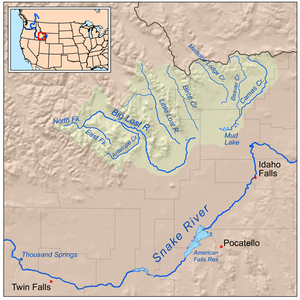 Beaver Creek is the second easternmost of Idaho's lost streams | |
 Location of the mouth of Beaver Creek in Idaho | |
Beaver Creek is a 58-mile (93 km) long[3] tributary of Camas Creek in the U.S. state of Idaho. Beginning at an elevation of 7,367 feet (2,245 m)[1] near Monida Pass in northern Clark County, it flows generally south through the communities of Humphrey, Spencer, and Dubois. Continuing into Jefferson County, it reaches its mouth north of the town of Hamer,[4] at an elevation of 4,810 feet (1,466 m).[2] It is roughly paralleled by Interstate 15 for its entire length.[4]
See also
References
- 1 2 Source elevation derived from Google Earth search using GNIS source coordinates.
- 1 2 3 4 "Beaver Creek". Geographic Names Information System. United States Geological Survey. June 21, 1979. Retrieved July 15, 2013.
- 1 2 "National Hydrography Dataset". United States Geological Survey. Retrieved July 15, 2013.
- 1 2 Idaho Road and Recreation Atlas (Map) (2nd ed.). 1:250,000. Benchmark Maps. 2010. pp. 57, 67. ISBN 978-0-929591-06-3. OCLC 567571371.
This article is issued from
Wikipedia.
The text is licensed under Creative Commons - Attribution - Sharealike.
Additional terms may apply for the media files.