Bearhat Mountain
| Bearhat Mountain | |
|---|---|
 Bearhat Mountain above the Hidden Lake trail | |
| Highest point | |
| Elevation | 8,689 ft (2,648 m) [1] |
| Prominence | 1,084 ft (330 m) [1] |
| Coordinates | 48°40′01″N 113°45′49″W / 48.66694°N 113.76361°WCoordinates: 48°40′01″N 113°45′49″W / 48.66694°N 113.76361°W[2] |
| Geography | |
 Bearhat Mountain | |
| Parent range | Lewis Range |
| Topo map | USGS Mount Cannon, MT |
| Climbing | |
| First ascent | 1923 (Norman Clyde)[1] |
Bearhat Mountain (8,689 feet (2,648 m)) is located in the Lewis Range, Glacier National Park in the U.S. state of Montana.[3] Bearhat Mountain is immediately west of Hidden Lake.
 Panorama with Bearhat Mountain at right, Hidden Lake below and Reynolds Mountain at distant left
 Bearhat Mountain at right rises over Hidden Lake
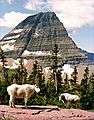 Bearhat Mountain with mountain goats posing
See also
References
- 1 2 3 "Bearhat Mountain, Montana". Peakbagger.com. Retrieved 2010-07-24.
- ↑ "Bearhat Mountain". Geographic Names Information System. United States Geological Survey. Retrieved 2010-07-24.
- ↑ Mount Cannon, MT (Map). TopoQwest (United States Geological Survey Maps). Retrieved June 4, 2018.
This article is issued from
Wikipedia.
The text is licensed under Creative Commons - Attribution - Sharealike.
Additional terms may apply for the media files.