Reynolds Mountain
| Reynolds Mountain | |
|---|---|
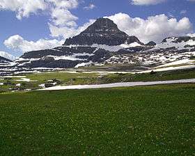 Reynolds Mountain as seen from Logan Pass | |
| Highest point | |
| Elevation | 9,125 ft (2,781 m) [1] |
| Prominence | 1,285 ft (392 m) [1] |
| Coordinates | 48°40′19″N 113°43′24″W / 48.67194°N 113.72333°WCoordinates: 48°40′19″N 113°43′24″W / 48.67194°N 113.72333°W [2] |
| Geography | |
 Reynolds Mountain | |
| Parent range | Lewis Range |
| Topo map | USGS Logan Pass, MT |
Reynolds Mountain (9,125 feet (2,781 m)) is located in the Lewis Range, Glacier National Park in the U.S. state of Montana.[1] Reynolds Mountain is situated along the Continental Divide and is easily seen from Logan Pass by looking due south from the pass. Hidden Lake is located below Reynolds Mountain to the west. Reynolds is a class 2(3) climb via the southwestern talus slope route that allows many people to easily climb the peak.
See also
References
- 1 2 3 "Reynolds Mountain, Montana". Peakbagger.com. Retrieved 2010-07-04.
- ↑ "Reynolds Mountain". Geographic Names Information System. United States Geological Survey. Retrieved 2010-07-04.

Reynolds Mountain is a classic horn, seen here from Bearhat Mountain
This article is issued from
Wikipedia.
The text is licensed under Creative Commons - Attribution - Sharealike.
Additional terms may apply for the media files.