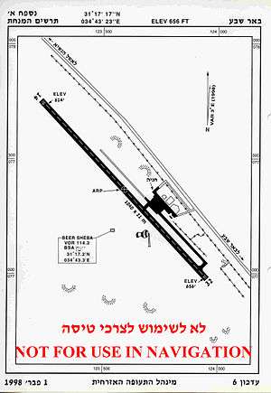
Be'er Sheva (Teyman) Airport
| Be'er Sheva Airport שדה תימן | |||||||||||
|---|---|---|---|---|---|---|---|---|---|---|---|
 | |||||||||||
| Summary | |||||||||||
| Airport type | Public | ||||||||||
| Operator | Ayit Aviation | ||||||||||
| Location | Beersheba | ||||||||||
| Elevation AMSL | 656 ft / 200 m | ||||||||||
| Coordinates | 31°17′13″N 34°43′22″E / 31.28694°N 34.72278°ECoordinates: 31°17′13″N 34°43′22″E / 31.28694°N 34.72278°E | ||||||||||
| Runways | |||||||||||
| |||||||||||
Be'er Sheva Airport (Hebrew: שְׂדֵה תֵּימָן), also known as the Teyman Airport (IATA: BEV, ICAO: LLBS) is an Israeli airport located near Beersheba. The airport is mainly used for teaching flying, private aviation activity, a gliding club and a skydiving center. The main operator of the airport is Ayit Aviation, owned by Captain Eli Peretz, who has managed the airport for the last 25 years.
History
British Mandate Era
The Sde Teyman strip was built during early WW2, for the use of the RAF to aid in the western desert campaign.
State of Israel
During the Suez Crisis the airstrip was converted for the IAF Mustang squadron.
As of 1958, Arkia started to have direct flights between Be'er Sheva and Eilat using DC3 planes.[1] The airfield was not well suited for commercial planes and due to dust and poor construction Arkia stopped the flights in 1960.[2] In 1964, after covering the airstrip with a special chemical coating, Arkia was able to start flying again.
In 1974 Arkia started to use the Islander planes[3] and added the Neve Zohar as a destination.
In 2001, the Israeli transportation agency declared that the airstrip would be upgraded and maintained. The maintenance started in 2003 and the airstrip was transferred to Ayit Aviation and Tourism.[4]
 RAF built Hardened aircraft shelter
 RAF British built hardened aircraft shelter
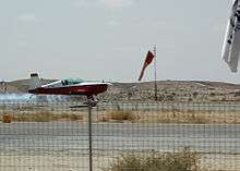
 Training plane in Sde Tayman
References
- ↑ jpress, 1958
- ↑ http://jpress.org.il/Olive/APA/NLI_Heb/SharedView.Article.aspx?parm=0EbkT2oG4Kz8rrD9GSRLhdzPRUYc%2FBZy%2BJmOdFAXCq%2Fw5xwi9exKt5KLl83eP3z1Yw%3D%3D&mode=image&href=AHR%2f1961%2f12%2f07&page=3&rtl=true
- ↑ http://jpress.org.il/Olive/APA/NLI_Heb/SharedView.Article.aspx?parm=s6OcSNIVh2vLNNIQ5qHuBVaPa11uQ9YwGuPtC82VXGS4hPGtfSeZ8UW3%2BORUuI8oYw%3D%3D&mode=image&href=DAV%2f1974%2f08%2f25&page=9&rtl=true
- ↑ https://www.port2port.co.il/article/%D7%94%D7%95%D7%91%D7%9C%D7%94-%D7%90%D7%95%D7%95%D7%99%D7%A8%D7%99%D7%AA/%D7%A9%D7%99%D7%93%D7%A8%D7%95%D7%92-%D7%9E%D7%A0%D7%97%D7%AA-%D7%A9%D7%93%D7%94-%D7%AA%D7%99%D7%9E%D7%9F-%D7%99%D7%97%D7%9C-%D7%91%D7%A9%D7%91%D7%95%D7%A2-%D7%94%D7%91%D7%90/