Atarot Airport
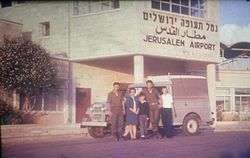
| Jerusalem International Airport נמל התעופה ירושלים مطار القدس الدولي | |||||||||||
|---|---|---|---|---|---|---|---|---|---|---|---|
 Atarot Airport, 1969 | |||||||||||
| Summary | |||||||||||
| Airport type | Military (and formerly: joint Public) | ||||||||||
| Operator | Israel Defense Forces | ||||||||||
| Location | Jerusalem | ||||||||||
| Opened | 1920 | ||||||||||
| Closed | October 2000 (closed to civilian traffic)[1] | ||||||||||
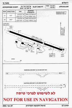
| Elevation AMSL | 2,485 ft / 757 m | ||||||||||
| Coordinates | 31°51′53″N 35°13′09″E / 31.86472°N 35.21917°ECoordinates: 31°51′53″N 35°13′09″E / 31.86472°N 35.21917°E | ||||||||||
| Map | |||||||||||
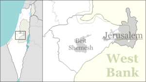 LLJR Location of Atarot Airport | |||||||||||
| Runways | |||||||||||
| |||||||||||
Atarot Airport (Hebrew: נמל התעופה ירושלים, Arabic: مطار القدس الدولي) (IATA: JRS, ICAO: LLJR, OJJR), (also Kalandia Airport, Qalandia Airport, and Jerusalem Airport) is a regional airport, currently not in use, located between Jerusalem and Ramallah. When it was opened in 1920 it was the first airport in the British Mandate for Palestine.
Royal Jordanian and Middle East Airlines were known to operate daily commercial flights to and from Atarot airport before 1967 under the Jordanian occupation.[2][3] After Israel occupied the West Bank after the Six-Day War in 1967, the airport fell under Israeli control. Arkia and El Al Israel Airlines operated daily commercial flights to and from the airport between 1967 and 2001,[4][5] when the airport was closed to the civilian traffic after the breakout of the Second Intifada in 2000.[6]
History
From 1920 until 1930, the airfield in Kalandia was the only airport in the British Mandate for Palestine. It was used by the British military authorities and prominent guests bound for Jerusalem.[7] In 1931, the Mandatory government expropriated land from the Jewish village of Atarot to expand the airfield, in the process demolishing homes and uprooting fruit orchards.[8] In 1936, the airport was opened for regular flights.[9] The village of Atarot was captured and destroyed by the Jordanian Arab Legion during the 1948 Arab-Israeli War.
From 1948 to the Six-Day War in June 1967, the airport was under Jordanian control, designated OJJR. Following the Six Day War, the Jerusalem airport was incorporated into the Jerusalem city municipal area and was designated LLJR.
In the 1970s and early 1980s, Israel invested considerable resources in upgrading the airport and creating the infrastructure for a full-fledged international airport but the international aviation authorities, bearing in mind that the airport was in lands occupied after 1967 by Israel, would not allow international flights to land there. Thus the airport was only used for domestic flights and charter flights.
Due to security issues during the Second Intifada, the airport was closed to civilian air traffic in October 2000 and by July 2001 it was formally handed over to the Israel Defense Forces.[1]
In maps presented by Israel at the 2000 Camp David Summit, Atarot was included in the Israeli built-up area of Jerusalem.[9] This was rejected by the Palestinian delegation, which envisioned it as a national airport for the Palestinians. Yossi Beilin proposed that the airport be used jointly as part of an overall sharing of Jerusalem between Israel and Palestinian Authority, citing the successful model of Geneva International Airport, which is used by both Switzerland and France.
Gallery
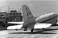 An Israeli aircraft at Atarot Airport in 1968
 The closed entrance to Atarot Airport in 2010, with a police jeep guarding
ICAO codes
The airport is sometimes shown with two different ICAO codes. The LL designator is used by ICAO for airports in Israel and OJ is the code for Jordan.
In popular culture
The airport is depicted in the film World War Z as the main Israeli airport defended from a zombie epidemic. In reality all the Israeli scenes in the film were shot in Malta.
See also
External links
| Wikimedia Commons has media related to Atarot airport. |
- Jerusalem Airport in lowshot website
References
- 1 2 Blumenkrantz, Zohar (27 July 2001). "Jerusalem's Atarot Airport handed over to the IDF". Independent Media Review and Analysis Newsletter. Kokhaviv Publications. Archived from the original on 2001-12-22. Retrieved 2014-09-13.
The Airports Authority and the Defense Ministry recently signed an agreement on the army's use of the Atarot airport in Jerusalem. The Israel Defense Forces effectively took over the airport for its own use after it was shut down for civilian air traffic shortly after the start of the Intifada last October [2000]...
- ↑
- ↑
- ↑
- ↑
- ↑ Derfner, Larry (2001-01-23). "An Intifada Casualty Named Atarot". The Jewish Journal of Greater Los Angeles. Retrieved 2007-11-07.
- ↑ An Empire in the Holy Land: Historical Geography of the British Administration of Palestine, 1917–1929 Gideon Biger, St. Martin's Press and Magnes Press, New York & Jerusalem, 1994, p. 152
- ↑ Oren-Nordheim, Michael; Kark, Ruth (2001). Jerusalem and Its Environs: Quarters, Neighborhoods, Villages, 1800–1948. Wayne State University Press. ISBN 0814329098.
- 1 2 Houk, Marian (Autumn 2008). "Atarot and the Fate of the Jerusalem Airport". The Applied Research Institute-Jerusalem. Institute of Jerusalem Studies. Retrieved 2014-09-13.
| Airports |
| ||||||
|---|---|---|---|---|---|---|---|
| Border terminals |
| ||||||
| Defunct or former properties | |||||||