Bayou Macon
| Bayou Macon | |
| Bayou | |
 Bayou Macon as seen from Poverty Point Reservoir State Park | |
| Country | United States |
|---|---|
| States | Arkansas, Louisiana |
| Source | Desha County, Arkansas 33°46′15″N 91°26′15″W / 33.77094°N 91.43762°W |
| Mouth | Confluence with the Tensas River in Catahoula Parish, Louisiana 31°54′49″N 91°32′52″W / 31.91349°N 91.54790°W |
| Length | 218 mi (351 km) |
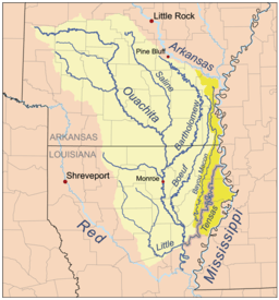 Map of the Tensas River Basin, including Bayou Macon | |
Bayou Macon is a bayou in Arkansas and Louisiana. It begins in Desha County, Arkansas, and flows south, between the Boeuf River to its west and the Mississippi River to its east, before joining Joe's Bayou south of Delhi in Richland Parish, Louisiana. Bayou Macon is about 218 miles (351 km) long.[1]
The bayou area saw action during the American Civil War including from the 1st Regiment Kansas Volunteer Infantry in May 1863 in the areas then known as Caledonia and Pin Hook.[2][3]
L. D. Knox of Winnsboro, a perennial Louisiana political candidate, owned approximately 1,400 acres (5.7 km2) of Bayou Macon land which he hand cleared and cultivated in what he considered to have been an aberrant but advanced style of agriculture.[4]
The Bayou Macon Wildlife Management Area comprises 6,919 acres in East Carroll Parish and was acquired by the Louisiana Department of Wildlife and Fisheries in 1991.[6]
References
- ↑ U.S. Geological Survey. National Hydrography Dataset high-resolution flowline data. The National Map Archived 2012-04-05 at WebCite, accessed June 3, 2011
- ↑ https://books.google.com/books?id=PjicJWUQhPYC&pg=PA198&lpg=PA198&dq=William+Y.+Roberts&source=bl&ots=9pIGwnfivI&sig=JIAUJgytVENSxpM6grCoD4uw_yU&hl=en&sa=X&ved=0ahUKEwjdwuO_q4jbAhUujK0KHcD7ALE4ChDoAQhJMA0#v=onepage&q=William%20Y.%20Roberts&f=false
- ↑ https://books.google.com/books?id=CLcZAAAAYAAJ&pg=PA697&lpg=PA697&dq=Zesch+caledonia&source=bl&ots=EqPeoJgCG_&sig=OFN1u-81aFTqKJyhrjAMeZDMDuU&hl=en&sa=X&ved=0ahUKEwisg42L1IbbAhVByoMKHbMoCJIQ6AEIPTAF#v=onepage&q=Zesch%20caledonia&f=false
- ↑ "Obituary of L.D. Knox". ’’Monroe News Star’’, June 1, 2009. Archived from the original on March 1, 2012. Retrieved June 6, 2009.
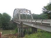
- ↑ "Jindal celebrates bridge opening in West Carroll, March 24, 2014". Monroe News-Star. Archived from the original on March 25, 2014. Retrieved March 25, 2014.
- ↑ "Bayou Macon | Louisiana Department of Wildlife and Fisheries". www.wlf.louisiana.gov. Retrieved 2017-05-05.
External links
- Columbia Encyclopedia entry
- Bayou Macon watershed -- U.S. Environmental Protection Agency
- Bayou Macon watershed -- Arkansas Natural Resources Commission
- Bayou Macon Wildlife Management Area (Louisiana Dept. of Wildlife & Fisheries)
- "Bayou Macon". Geographic Names Information System. United States Geological Survey. Retrieved 2014-01-05.