Baxter Estates, New York
| Baxter Estates, New York | |
|---|---|
| Village | |
| Village of Baxter Estates | |
| Nickname(s): VBE | |
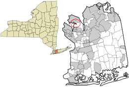 Location in Nassau County and the state of New York. | |
 Location within the state of New York | |
| Coordinates: 40°50′2″N 73°41′43″W / 40.83389°N 73.69528°WCoordinates: 40°50′2″N 73°41′43″W / 40.83389°N 73.69528°W | |
| Country | United States |
| State | New York |
| County | Nassau |
| Government | |
| • Mayor | Nora Haagenson |
| • Deputy Mayor | Charles Comer |
| Area | |
| • Total | 0.2 sq mi (0.5 km2) |
| • Land | 0.2 sq mi (0.5 km2) |
| • Water | 0.0 sq mi (0.0 km2) |
| Elevation | 39 ft (12 m) |
| Population (2010) | |
| • Total | 999 |
| • Estimate (2016)[1] | 1,059 |
| • Density | 5,000/sq mi (2,000/km2) |
| Time zone | UTC-5 (Eastern (EST)) |
| • Summer (DST) | UTC-4 (EDT) |
| ZIP code | 11050 |
| Area code(s) | 516 |
| FIPS code | 36-04803 |
| GNIS feature ID | 0943176 |
| Website |
www |
The Village of Baxter Estates (also known as VBE) is a village in Nassau County, New York, United States, in the town of North Hempstead. The population was 999 at the 2010 census.[2]
Geography
Baxter Estates is located at 40°50′2″N 73°41′43″W / 40.83389°N 73.69528°W (40.833975, -73.695246).[3]
According to the United States Census Bureau, the village has a total area of 0.2 square miles (0.52 km2), all of it land.
History
Baxter Estates owes much of its history to the homestead settlement of "Cow Neck" built in 1673 by John Betts and Robert Hutchings, which still stands on its original site at the corner of Central Drive and Shore Road, overlooking Manhasset Bay. In c. 1741 this property was purchased by Oliver Baxter, and maps of the time show that an entire wigwam village, belonging to the Matinecock Indians, may have been located on Baxter's land.
The Baxters, who were shipbuilders, whalers and sea captains, retained the property until the 19th century. Hessian troops were quartered in the Baxter House during the Revolutionary War, and in 1895 the first library of Port Washington met in the parlor of the Baxter house. The residence is now a designated historic building. The current owner, Sabrina Wu, was in the process of submitting plans to demolish the landmarked home when a massive blaze broke out heavily damaging the home on February 5, 2017.[4] The cause of the fire was not determined.[5]
The Village of Baxter Estates was incorporated in 1931.
Demographics
| Historical population | |||
|---|---|---|---|
| Census | Pop. | %± | |
| 1940 | 760 | — | |
| 1950 | 862 | 13.4% | |
| 1960 | 932 | 8.1% | |
| 1970 | 1,026 | 10.1% | |
| 1980 | 911 | −11.2% | |
| 1990 | 961 | 5.5% | |
| 2000 | 1,006 | 4.7% | |
| 2010 | 999 | −0.7% | |
| Est. 2016 | 1,059 | [1] | 6.0% |
| U.S. Decennial Census[6] | |||
As of the census[7] of 2000, there were 1,006 people, 376 households, and 262 families residing in the village. The population density was 5,574.4 people per square mile (2,157.9/km²). There were 386 housing units at an average density of 2,138.9 per square mile (828.0/km²). The racial makeup of the village was 84.00% White, 2.68% African American, 0.10% Native American, 7.16% Asian, 3.98% from other races, and 2.09% from two or more races. Hispanic or Latino of any race were 14.61% of the population.
There were 376 households out of which 36.4% had children under the age of 18 living with them, 57.2% were married couples living together, 8.5% had a female householder with no husband present, and 30.1% were non-families. 25.3% of all households were made up of individuals and 10.9% had someone living alone who was 65 years of age or older. The average household size was 2.68 and the average family size was 3.21.
In the village, the population was spread out with 24.8% under the age of 18, 6.2% from 18 to 24, 29.0% from 25 to 44, 27.1% from 45 to 64, and 12.9% who were 65 years of age or older. The median age was 39 years. For every 100 females, there were 99.2 males. For every 100 females age 18 and over, there were 95.6 males.
The median income for a household in the village was $84,592, and the median income for a family was $111,074. Males had a median income of $56,250 versus $51,250 for females. The per capita income for the village was $44,718. About 3.0% of families and 4.7% of the population were below the poverty line, including 5.0% of those under age 18 and 6.3% of those age 65 or over.
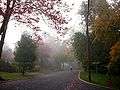
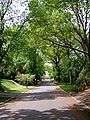
Gallery


References
- 1 2 "Population and Housing Unit Estimates". Retrieved June 9, 2017.
- ↑ "Race, Hispanic or Latino, Age, and Housing Occupancy: 2010 Census Redistricting Data (Public Law 94-171) Summary File (QT-PL), Baxter Estates village, New York". U.S. Census Bureau, American FactFinder 2. Archived from the original on September 11, 2013. Retrieved September 30, 2011.
- ↑ "US Gazetteer files: 2010, 2000, and 1990". United States Census Bureau. 2011-02-12. Retrieved 2011-04-23.
- ↑ "Massive Blaze at Historical Baxter House Under Investigation". Port Washington, NY Patch. 2017-02-05. Retrieved 2017-02-07.
- ↑ "Officials: Cause of Baxter House fire unknown". Newsday. Retrieved 2017-02-07.
- ↑ "Census of Population and Housing". Census.gov. Archived from the original on May 12, 2015. Retrieved June 4, 2015.
- ↑ "American FactFinder". United States Census Bureau. Archived from the original on 2013-09-11. Retrieved 2008-01-31.
External links
| Wikimedia Commons has media related to Baxter Estates, New York. |
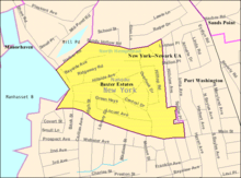
Places adjacent to Baxter Estates, New York | ||||||||||
|---|---|---|---|---|---|---|---|---|---|---|
| ||||||||||