Baucau Airport
| Baucau Airport | |||||||||||
|---|---|---|---|---|---|---|---|---|---|---|---|
 | |||||||||||
| Summary | |||||||||||
| Airport type | Public / Military | ||||||||||
| Operator | Government | ||||||||||
| Serves | Baucau, East Timor | ||||||||||
| Elevation AMSL | 1,777 ft / 542 m | ||||||||||
| Coordinates | 08°29′07″S 126°23′57″E / 8.48528°S 126.39917°ECoordinates: 08°29′07″S 126°23′57″E / 8.48528°S 126.39917°E | ||||||||||
| Runways | |||||||||||
| |||||||||||
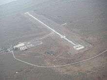
Baucau Airport (IATA: BCH, ICAO: WPEC), former Cakung Airport, is an unattended airport located 6.5 km (4.0 mi) west of Baucau, a city in East Timor (Timor-Leste).[1][2][3]
Baucau Airport has a much longer runway than Dili's Presidente Nicolau Lobato International Airport. Prior to 1975 this airport had been used for international flights, including those of Trans Australia Airlines from Australia. Following the Indonesian invasion in 1975, this airport was taken over by the Indonesian military and closed to civilian traffic.
During the Indonesian occupation of East Timor, the airport served as a base for aircraft of the Indonesian Air Force, who were stationed for counter-insurgency effort toward the pro-independence guerilla.
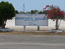
Sign posted at outside the parking ramp at Cakung Airport in October 2009
References
- 1 2 Aeronautical Information Publication (AIP) Archived 2008-08-27 at the Wayback Machine. from Timor-Leste Civil Aviation Department Archived August 4, 2007, at the Wayback Machine.
- 1 2 Airport information for WPEC at World Aero Data. Data current as of October 2006.Source: DAFIF.
- 1 2 Airport information for BCH at Great Circle Mapper. Source: DAFIF (effective October 2006).
External links
This article is issued from
Wikipedia.
The text is licensed under Creative Commons - Attribution - Sharealike.
Additional terms may apply for the media files.