Battersea Railway Bridge
| Battersea Railway Bridge | |
|---|---|
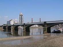 Battersea Railway Bridge from the south west | |
| Coordinates | 51°28′24″N 0°10′48″W / 51.4734°N 0.179901°WCoordinates: 51°28′24″N 0°10′48″W / 51.4734°N 0.179901°W |
| Carries | Railway |
| Crosses | River Thames |
| Locale | London, England |
| Maintained by | Transport for London |
| Heritage status | Grade II* listed structure |
| Preceded by | Diamond Jubilee Footbridge (two shared piers - in construction) |
| Followed by | Battersea Bridge |
| Characteristics | |
| Design | Arch bridge |
| Total length | 230m (plus approaches) |
| Width | 10.5m |
| Longest span | 42.5m |
| Clearance below | 6m (above MHWS) |
| History | |
| Opened | 2 March 1863 |
| Statistics | |
| Daily traffic | 8 scheduled passenger trains per hour (05:45 - 23:30), plus additional unscheduled freight trains |
The Battersea Railway Bridge (originally called the Cremorne Bridge, after riverside public gardens in Chelsea, and formerly commonly referred to as the Battersea New Bridge) is a bridge across the River Thames in London, between Battersea and Fulham. Owned by Network Rail Infrastructure Ltd (who use its official name of Chelsea River Bridge) it connects to the extreme north-east part of Fulham, known as Chelsea Harbour or Imperial Wharf, a 21st century-rebuilt area on the south side of a Chelsea Creek. The bridge is used by the West London Line of the London Overground from Clapham Junction to Willesden Junction.
History
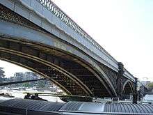
The bridge was designed by William Baker,[1] chief engineer of the London and North Western Railway, and was opened on 2 March 1863[2] at a cost of £87,000 (equivalent to £7,600,000 in 2016).[3] It carries two tracks and consists of five 120-foot (37 m) lattice girder arches set on stone piers.[4]
A three-arch brick viaduct carries the line on the north side of the bridge, with one arch having been opened to provide a pedestrian route under the railway, as part of the Thames Path. On the south side are four arches, two of which are used as storage for the residents of a houseboat community moored immediately downstream.[4] Completion of a plaza containing a residential/leisure tower, Lombard Wharf is scheduled for 2017 immediately south-west of the bridge. The plans for which have entailed re-opening an arch of the viaduct to provide a continuous boardwalk.[5]
The bridge was strengthened and refurbished in 1969, and again in 1992. During a high tide in late 2003, the structure was struck by a refuse-barge damaging some lower structural elements significantly: repairs were completed in early 2004.[6]
In November 2013, planning permission was granted for the Diamond Jubilee Footbridge, extending the two central piers of the bridge upstream.[7]
Trains crossing are subject to a 20/30 mph speed limit (locomotive-hauled traffic is restricted to 20 mph, all other traffic is limited to 30 mph).[2]
The bridge was declared a Grade II* listed structure in 2008, providing protection to preserve its special character from unsympathetic development.[8]
See also
Notes and references
- References
- ↑ Cookson, Brian (2006). "London's Thames Bridges basic facts". Guided London walks.
- 1 2 "Battersea Railway Bridge Tour UK". TourUK. Archived from the original on 20 June 2012.
- ↑ "Battersea Railway Bridge". Where Thames Smooth Waters Glide. Retrieved 15 December 2013.
- 1 2 "River access supports Battersea Bridge refurb". Maritime Journal. 24 June 2013. Retrieved 15 December 2013.
- ↑ "Lombard Wharf SW11". Barratt Developments PLC. 2013. Retrieved 2 January 2017.
- ↑ "Inspection Report Detailed Bridge Assessments Sub-Package 2A" (PDF). Retrieved 15 December 2013.
- ↑ "Home". Diamond Jubilee Bridge. Retrieved 2 January 2017.
- ↑ "London bridges get listed status". BBC News. Retrieved 26 November 2008.
- Notes
Further reading
- Loobet, Patrick (2002). Battersea Past. Historical Publications Ltd. p. 49. ISBN 0-948667-76-1.
External links
| Wikimedia Commons has media related to Battersea Railway Bridge. |
Coordinates: 51°28′23″N 0°10′45″W / 51.47306°N 0.17917°W
| |||||||||||||||||||||