Batha (prefecture)
| Batha Prefecture Préfecture du Batha | |||||
| Prefecture of Chad | |||||
| |||||
 | |||||
 | |||||
| Capital | Ati 13°12′N 18°20′E / 13.200°N 18.333°ECoordinates: 13°12′N 18°20′E / 13.200°N 18.333°E | ||||
| Government | Prefecture | ||||
| Historical era | Cold War | ||||
| • | Established[1] | 13 February 1960 | |||
| • | Disestablished[1] | 1 September 1999 | |||
| Area | |||||
| • | 1960 | 100,000 km2 (38,610 sq mi) | |||
| • | 1993 | 88,800 km2 (34,286 sq mi) | |||
| Population | |||||
| • | 1960 | 279,873 | |||
| Density | 2.8 /km2 (7.2 /sq mi) | ||||
| • | 1993 | 288,458 | |||
| Density | 3.2 /km2 (8.4 /sq mi) | ||||
| Political subdivisions | Sub-prefectures (1993)[2]
| ||||
| Area and population source:[1] | |||||
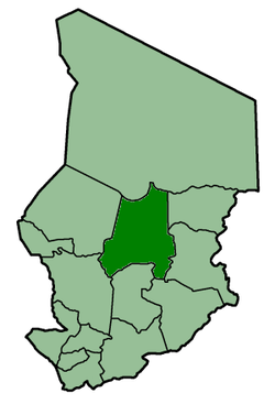
Batha Prefecture was one of the 14 prefectures of Chad. Located in the center of the country, Batha covered an area of 88,800 square kilometers and had a population of 288,458 in 1993. Its capital was Ati, Chad. It is largely coextensive with the current Batha Region.
References
- 1 2 3 "Administrative Divisions of Countries: Regions of Chad". www.statoids.com.
- ↑ "Administrative Divisions of Countries: Departments of Chad". www.statoids.com.
| |||
|
Batha · Biltine · Borkou-Ennedi-Tibesti · Chari-Baguirmi · Guéra · Kanem · Lac · Logone Occidental · Logone Oriental · Mayo-Kébbi · Moyen-Chari · Ouaddaï · Salamat · Tandjilé · | |||
|
See also : Regions of Chad - Departments of Chad |
This article is issued from
Wikipedia.
The text is licensed under Creative Commons - Attribution - Sharealike.
Additional terms may apply for the media files.