Bardsey, West Yorkshire
| Bardsey | |
|---|---|
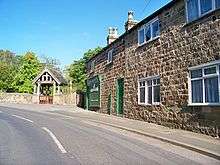
 Main Street: The Bingley Arms in Bardsey, perhaps Britain's oldest pub. | |
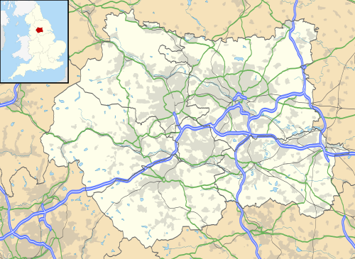 Bardsey Bardsey shown within West Yorkshire | |
| OS grid reference | SE367432 |
| • London | 170 mi (270 km) SSE |
| Civil parish | |
| Metropolitan borough | |
| Metropolitan county | |
| Region | |
| Country | England |
| Sovereign state | United Kingdom |
| Post town | LEEDS |
| Postcode district | LS17 |
| Dialling code | 01937 |
| Police | West Yorkshire |
| Fire | West Yorkshire |
| Ambulance | Yorkshire |
| EU Parliament | Yorkshire and the Humber |
| UK Parliament | |
Bardsey, West Yorkshire, England is a small village in the City of Leeds metropolitan borough, 8 miles (13 km) north east of Leeds city centre. The village is in the LS17 Leeds postcode district. It is part of the civil parish of Bardsey cum Rigton. The village itself lies just off the A58 road between Leeds and Wetherby.
It is a predominantly middle class area with a high proportion of retired residents. Housing is mixed; while most is private, there is council housing situated near Keswick Lane. Facilities include a public house and sports club (with a cricket pitch and two football pitches). Bardsey also has a Primary school and an Anglican church.
History
Nearby earthworks named Pompocali are of uncertain origin, but possibly a result of granite quarrying. A minor Roman road lies alongside it, suggesting that Pompocali results from Roman activity.[1]

Bardsey was mentioned 1086 in the Domesday Book as "Berdesei" and "Bereleseie" in the hundred of Skyrack.[2] A motte-and-bailey castle dates back to the time immediately following the Norman conquest.[3] Bardsey also claims the oldest Anglo-Saxon tower church in England, with the tower of All Hallows church dating back to c. 850–950.[4]
The Bingley Arms are a public house that claims to be England's oldest public house, and to be recorded in the Domesday Book, although these claims are disputed.[5]
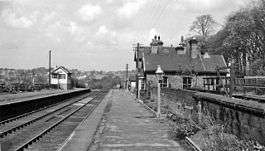
Bardsey railway station on the Cross Gates–Wetherby line opened in 1876 and closed in 1964.[6]
Notable people
Bardsey is the birthplace of playwright and poet William Congreve.
Location grid
Places adjacent to Bardsey, West Yorkshire | ||||||||||
|---|---|---|---|---|---|---|---|---|---|---|
| ||||||||||
References
- ↑ Hill, H.M. "Archaeology of Pompocali Earthworks and Hetchell Crags". Archived from the original on 28 September 2009.
- ↑ Bardsey in the Domesday Book. Retrieved 19 October 2017.
- ↑ Historic England. "Castle Hill motte and bailey castle (1012774)". National Heritage List for England. Retrieved 19 October 2017.
- ↑ Historic England. "Church of All Hallows (1135652)". National Heritage List for England. Retrieved 19 October 2017.
- ↑ Fox, Geoff (15 February 2005). "Beware mock heritage in our 'historic' pubs". Yorkshire Evening Post. Retrieved 14 December 2007.
- ↑ Catford, Nick. "Bardsey". Disused Stations. Retrieved 19 October 2017.
External links

- The Corpus of Romanesque Sculpture in Britain and Ireland: All Hallows, Bardsey, West Yorkshire
- Bardsey Village web-site
- Bardsey Cricket Club website
- "The Ancient Parish of Bardsey". Genuki. Archived from the original on 13 October 2007. Retrieved 1 November 2016.