Barbaira (river)
| Torrente Barbaira | |
|---|---|
 | |
| Country | Italy |
| Physical characteristics | |
| Main source |
between punta dell'Arpetta and monte Simonasso around 1,450 m (4,760 ft) |
| River mouth |
Nervia at ponte Barbaira, Italy 71 m (233 ft) 43°51′41″N 7°37′24.17″E / 43.86139°N 7.6233806°ECoordinates: 43°51′41″N 7°37′24.17″E / 43.86139°N 7.6233806°E |
| Length | 15.83 km (9.84 mi)[1] |
| Basin features | |
| Basin size | 35.99 km2 (13.90 sq mi)[2] |
The Barbaira is a 15.83-kilometre (9.84 mi) stream of Liguria (Italy); it is the main tributary of the Nervia.
Geography
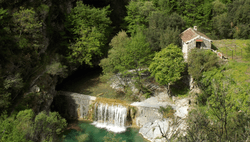
The stream rises between punta dell'Arpetta and monte Simonasso, in the Ligurian Alps, and flows through a woody valley mainly heading south-east. When it reaches the centre of the comune of Rocchetta Nervina it gets from left side the waters of its main tributary, rio Oggia. It enters the Nervia at ponte Barbaira (71 m).[3]
Main tributaries
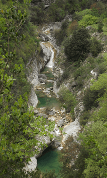
Intermediate course of the Barbaira.
Sport
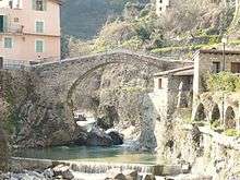
Old bridge on the Barbaira in Rocchetta Nervina.
The Barbaria is a well known site for practicing canyoning.[4]
Related articles
References
- ↑ (in Italian)Piano di bacino - Nervia - CAPITOLO 2, Provincia di Imperia, on-line in pdf: "Archived copy" (PDF). Archived from the original (PDF) on 2015-05-18. Retrieved 2015-05-15. (access: 2015-05-08)
- 1 2 (in Italian)Piano di bacino - Nervia, Provincia di Imperia, on-line in pdf: "Archived copy" (PDF). Archived from the original (PDF) on 2013-06-27. Retrieved 2015-05-15. (access: 2015-05-08)
- ↑ 1:25.000 map of the Istituto Geografico Militare, on-line on www.pcn.minambiente.it/viewer
- ↑ "Archivio della Categoria 'Canyoning'". www.rocchettanervina.com. municipality of Rocchetta Nervina. Retrieved May 15, 2015.
See also
External links
![]()
- (in Italian) Canyoning Barbaira: canyoning along the stream on www.ufficioguidefinale.it
- (in French) Rio Barbaira Rochetta Nervina (Imperia), French page on www.descente-canyon.com
This article is issued from
Wikipedia.
The text is licensed under Creative Commons - Attribution - Sharealike.
Additional terms may apply for the media files.