Banks Peninsula Track
The Banks Track is a 30 kilometre tramping track on the Banks Peninsula on the South Island of New Zealand in the Canterbury region. The track opened in 1989 as the first privately owned track in New Zealand.
Tramping
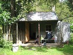
The track is open from October through April. Hut accommodations along the track are unique and well-equipped.
The route
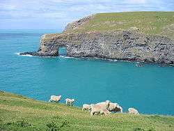
Both the two-day and three-day track options start and end in Akaroa and reached a maximum altitude of 699 metres (2,293 ft) at Trig GG, traversing a rugged coastline, forests, bush, pastures, and the Hinewai Reserve.
The track sections are:
- Onuku Farm (outside Akaroa) to Flea Bay Cottage (11 km)
- Flea Bay Cottage to Stony Bay Cottage (8 km)
- Stony Bay Cottage to Akaroa (11 km)
| Point | Coordinates (links to map & photo sources) |
Notes |
|---|---|---|
| Onuku Farm Trampers' Hut | 43°50′41″S 172°57′00″E / 43.844650°S 172.950019°E | |
| Trig GG | 43°51′11″S 172°57′52″E / 43.852957°S 172.964386°E | |
| Mortlock's Mistake | 43°50′46″S 172°58′47″E / 43.846053°S 172.979590°E | |
| Flea Bay Cottage | 43°52′00″S 173°00′13″E / 43.866691°S 173.003679°E | |
| Stony Bay Cottages | 43°51′16″S 173°02′15″E / 43.854491°S 173.037447°E | |
| Mount Vernon Lodge | 43°48′29″S 172°58′53″E / 43.808057°S 172.981305°E |
Flora and fauna
Among the fauna that may be observed are yellow-eyed penguins, little penguins, spotted shags, sooty shearwaters, fur seals, and Hector's dolphins. Flora observed include nikau palm, kahikatea, and tree ferns. [2]
Ecotourism
The establishment and ongoing stewardship of the track is an example of ecotourism. The track was established by ten landowners, mostly farmers, as a means of supplementing income in response to the fiscal pressures caused by drought and elimination of farm subsidies in the 1980s. A limited liability company was formed to manage track operations. In return for use of the land, track maintenance, and providing accommodations, landowners are given an annual sum based on several factors, including the amount of land traversed by the track and level of responsibility for track operations. [3]
References
- ↑ Hayward, Michael (5 November 2016). "Banks Track cut down to three days at the end of the season". The Press. p. A16. Retrieved 5 November 2016.
- ↑ DuFresne, Jim (2002). Tramping in New Zealand. Melbourne: Lonely Planet Publications. ISBN 1-74059-234-4.
- ↑ Hargreaves, Bob (2002). "The Banks Peninsular Track-A Case Study In Rural Tourism" (PDF). Retrieved 2006-05-20.
External links
Coordinates: 43°51′11″S 172°57′52″E / 43.852957°S 172.964386°E