Banaybanay, Davao Oriental
| Banaybanay | |
|---|---|
| Municipality | |
| Municipality of Banaybanay | |
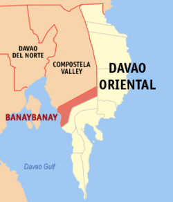 Map of Davao Oriental with Banaybanay highlighted | |
.svg.png) Banaybanay Location within the Philippines | |
| Coordinates: 7°06′N 126°04′E / 7.1°N 126.07°ECoordinates: 7°06′N 126°04′E / 7.1°N 126.07°E | |
| Country |
|
| Region | Davao Region (Region XI) |
| Province | Davao Oriental |
| District | 2nd District |
| Barangays | 14 (see Barangays) |
| Government [1] | |
| • Type | Sangguniang Bayan |
| • Mayor | Adalia Lopez Tambuang |
| • Electorate | 25,750 voters (2016) |
| Area [2] | |
| • Total | 408.52 km2 (157.73 sq mi) |
| Population (2015 census)[3] | |
| • Total | 41,117 |
| • Density | 100/km2 (260/sq mi) |
| Time zone | UTC+8 (PST) |
| ZIP code | 8208 |
| PSGC | 112502000 |
| IDD : area code | +63 (0)87 |
| Climate type | Tropical rainforest climate |
| Income class | 2nd municipal income class |
| Revenue (₱) | 140,630,536.63 (2016) |
| Native languages |
Davawenyo Surigaonon Cebuano Kalagan language Kamayo Tagalog |
| Website |
banaybanay |
Banaybanay, officially the Municipality of Banaybanay, is a 2nd class municipality in the Province of Davao Oriental, Philippines. According to the 2015 census, it has a population of 41,117 people.[3]
Banaybanay is derived from the two native word "Banay", (Kalagan word) means sprout due to its main livelihood in the area which is rice farming, and "Bânay" (Cebuano word) means clans due to the family clans that arrived in that area that came from Visayas Islands and Luzon and settled there along together with the Kalagans and Mandayan Natives.
Barangays
Banaybanay is politically subdivided into 14 barangays.
- Cabangcalan
- Caganganan
- Calubihan
- Causwagan
- Punta Linao
- Mahayag
- Maputi
- Mogbongcogon
- Panikian
- Pintatagan
- Piso Proper
- Poblacion
- San Vicente
- Rang-ay
History
Banaybanay was primarily inhabited by the Mandayas in the uplands of Causwagan, Panikian and Mahayag, and Kalagans in shorelines and the mouth rivers of Piso, Pongoton, Mogbongcogon and Maputi which they have a strong settlement and a Muslim governance on that area leads by a Datus or Imams.
Around the 1800s before Uyanguren arrived in the Davao, there was a strong community of the Kalagans (Kagan) in the Piso which was led by a chieftain named Datu Panayangan. Their dwelling was along the Piso River along with his people who lived there peacefully.
The story of the arriving of the Kallaw people from Samal Island is very well known especially among the Kalagans of Banaybanay. They arrived in the Piso to settled there along with their Kalagan Brothers on the permission of Datu Panayangan. The Kallaw chieftain named Datu Lamaran reconciled to Datu Panayangan to settle the swampy place of Piso which later was called Barrio Pongoton from the word pangotanan which means a place of abundance of fish and crabs to catch.
Until now, the grandsons or the clans of Datu Panayangan and Datu Lamaran are still living on the areas that divide into many families.
Second World War
On the time of Japanese occupation, Banaybanay (formerly known as Piso) gives an important location for the Japanese on the Second World War due to its strategic location in the Davao Gulf. The Japanese established a Camp called Piso Camp in Barangay Calubihan.
Demographics
| Population census of Banaybanay | ||
|---|---|---|
| Year | Pop. | ±% p.a. |
| 1970 | 14,866 | — |
| 1975 | 19,894 | +6.02% |
| 1980 | 24,644 | +4.37% |
| 1990 | 29,606 | +1.85% |
| 1995 | 33,082 | +2.10% |
| 2000 | 33,714 | +0.41% |
| 2007 | 35,693 | +0.79% |
| 2010 | 39,121 | +3.39% |
| 2015 | 41,117 | +0.95% |
| Source: Philippine Statistics Authority[3] [4] [5] [6] | ||
References
- ↑ "Municipality". Quezon City, Philippines: Department of the Interior and Local Government. Retrieved 31 May 2013.
- ↑ "Province: Davao Oriental". PSGC Interactive. Quezon City, Philippines: Philippine Statistics Authority. Retrieved 12 November 2016.
- 1 2 3 Census of Population (2015). "Region XI (Davao Region)". Total Population by Province, City, Municipality and Barangay. PSA. Retrieved 20 June 2016.
- ↑ Census of Population and Housing (2010). "Region XI (Davao Region)". Total Population by Province, City, Municipality and Barangay. NSO. Retrieved 29 June 2016.
- ↑ Censuses of Population (1903–2007). "Region XI (Davao Region)". Table 1. Population Enumerated in Various Censuses by Province/Highly Urbanized City: 1903 to 2007. NSO.
- ↑ "Province of Davao Oriental". Municipality Population Data. Local Water Utilities Administration Research Division. Retrieved 17 December 2016.
External links
- Banaybanay, Davao Oriental Official Website
- Philippine Standard Geographic Code
- Philippine Census Information
- Local Governance Performance Management System
Places adjacent to Banaybanay, Davao Oriental | |
|---|---|
Mati (capital) | |
| Municipalities | |
| Component cities | |