Ban Gioc–Detian Falls
Coordinates: 22°51′23″N 106°43′19″E / 22.8564°N 106.7220°E

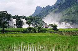
Ban Gioc – Detian Falls (Vietnamese: thác Bản Giốc, Đức Thiên-Bản Ước Chinese: Détiān pùbù, Bǎnyuē pùbù 板約瀑布, 德天瀑布) is a collective name for two waterfalls on the Quây Sơn River (Chinese: Guichun River (Vietnamese: Quy Xuân Hà), 归春河), that straddle the international border between China and Vietnam; more specifically located between the Karst hills of Daxin County, Guangxi,(Vietnamese: Đại Tân, Quảng Tây) and Trùng Khánh District, Cao Bằng Province. (Chinese Chongqing,Gaoping 重庆,高平) The waterfall is 272 km (169 mi) north of Hanoi.
Characteristics
Over thousands of years the waterfall has eroded its crest and slowly moved upstream. It currently appears to be two waterfalls most of the time but when the river is swollen due to summer rains can form one fall again.
In Vietnamese, the two falls are considered as two parts of one waterfall with the sole name Bản Giốc. The two parts are thác chính (Main waterfall) and thác phụ (Subordinate waterfall). Chinese texts sometimes name both falls from the Détiān falls on the Chinese side.[1]
The waterfall drops 30 m (98 ft). It is separated into three falls by rocks and trees, and the thundering effect of the water hitting the cliffs can be heard from afar.[2]
It is currently the 4th largest waterfall along a national border, after Iguazu Falls, Victoria Falls, and Niagara Falls.[3] Somewhat nearby is the 1000m long by 200m wide Tongling Gorge (tōng líng dà xiá gǔ 通灵大峡谷 "Tongling Grand Canyon") in Jingxi County (jìng xī xiàn 靖西县), Baise City (bǎi sè shì 百色市) of Guangxi, accessible only through a cavern from an adjoining gorge. Rediscovered only recently, it has many species of endemic plants, found only in the gorge.
Geology
The waterfalls are located in an area of mature karst formations where the original limestone bedrock layers are being eroded. Numerous streams spring from underground fissures along the lower levels of the area. The waterfalls have multiple drops, from bedrock layer to layer, which shows the multiple depositions of sediments of different hardness which formed the terrain over millions of years.
History
A road running along the top of the falls leads to a stone marker that demarcates the border between China and Vietnam in French and Chinese. Modern disputes arose as there are discrepancies as to the correlating legal documents on border demarcation and the placement of markers between the French and Qing administrations in the 19th century.[4]
Disputes regarding the border demarcation at this location were settled in 1999 Viet Nam-China Treaty on Land Borderline. Additional talks were held as late as 2009 to clarify the treaty.[5] However, there are controversies regarding the border demarcation around the Falls. One faction holds that the entirety of these falls belongs to Vietnam, and that the stone tablet had been moved there some time during or after the brief Sino-Vietnamese war of 1979.[6] Also, these falls were not documented in any Chinese texts until recently. To the southeast, the land dispute also along the Sino-Vietnamese border also includes Nam Quan Gate (Ải Nam Quan) which the Vietnamese claimed as well. Historically,[7][8][9] Nam Quan Gate served as the border marker and entry point to Vietnam between Vietnam & China (hence there's also a Vietnamese historical saying,[10] that Vietnam stretched from Cape Cà Mau to Ải Nam Quan).
Impact on industry and commerce
The waterfalls increase the quality of life for people who live within the sound of the falls. A road running along the top of the falls leads to a stone marker that demarcates the border between China and Vietnam in French and Chinese. 20th century disputes could not be resolved where inaccuracies in documents, maps and descriptions that were made in the 19th century became difficult to universally comprehend. The disappearance or inaccurate replacement of markers and landmarks from time to time, and the varied patterns of transportation, settlement and land use from generation to generation, and the successive administrative differences throughout periods of war and strife led to both Vietnam and China understanding that exactly defining the border would increase prosperity in the long term.[4]
The commercial focus of the area directly around the falls will likely remain tourism.
Transport
There are two directional aspects to transport at a waterfall: (1) portage along the river's course; and (2) fording or rafting across the river. Ban Gioc–Detian Falls was one of the crossing points for Chinese forces during the Sino-Vietnamese War. Rafts are currently used to boat tourists closer to the falls and return them to their dock of origination.
Preservation efforts
Preservation of the resource may require future cooperation between the local communities by use of a perpetual joint oversight committee.
Tourism
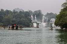
The few Western tourists who have visited the falls enjoy the natural views and sounds. The waterfalls are visited by many people from China and Vietnam every year, being a shared natural treasure. The preferred Vietnam route is via Hanoi. The preferred China route is via Jingxi County. Many people have had enjoyable visits which they have recounted.[11] There are many way to get to Ban Gioc waterfall from Hanoi. If you have time and are free-style, you can get a public bus to Cao Bang city and rent a motobike from here within 2 hours or so to reach the waterfall. This may be suitable for backpacker travelers. For tourists who dont have much time and have no ideas how to go there, there are many tours from recommended tour operators in Hanoi that you can try. Private tours are highly recommended as you will have more time to discover landscape and exotic beauty of the waterfall and Cao Bang Geopark.
References
- ↑ 韩欣 中国名水 (Han Xin, Famous Waters of China) 2005 Volume 2 "德天瀑布位于广西南宁地区边陲大新县,在中越边境交界处.归春河上游,瀑布气势磅薄、银瀑飞泻.三级跌落,蔚为 ... 夏季,德天瀑布和板约瀑布会连在一起,应该是整个德天风景区一道最为奇特的景观。它们浩浩荡荡地飞奔而下,像是凭空而降的一支巨大的 ..."
- ↑ "Cao Bang - the land of mountains and water". Retrieved 2007-02-13.
- ↑ "Top 10 most beautiful Chinese waterfalls". China Central Television. Retrieved 2011-11-12.
- 1 2 Vietnamese Embassy: On the settlement of Vietnam-China border issue vietnamembassy-usa.org
- ↑ Vietnam and China's land demarcation itinerary
- ↑ The implementation of Vietnam-China land border treaty: bilateral and regional implications. Do Thi Thuy 5/3/2009 PDF
- ↑ Han Nam Quan 3 (English) Archived 2014-08-31 at the Wayback Machine.
- ↑ "In Westminster, an Internet Bid to Restore Viet Land" Los Angeles Times
- ↑ Interview On Territory And Territorial Waters - General
- ↑ Asia Finest Discussion Forum > Ai Nam Quan - An example of communist sellout of Motherland
- ↑ "Guichun River | china diaries". catbirdinchina.wordpress.com. Retrieved 2017-12-30.
External links
| Wikimedia Commons has media related to Ban Gioc Waterfalls. |
- Cao Bằng Provincial Government website (English version)
- Falls photo gallery