Balud, Masbate
| Balud | ||
|---|---|---|
| Municipality | ||
| Municipality of Balud | ||
 Silhouette of Jintotolo Island | ||
| ||
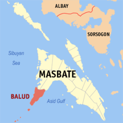 Map of Masbate with Balud highlighted | ||
.svg.png) Balud Location within the Philippines | ||
| Coordinates: 12°02′N 123°12′E / 12.03°N 123.2°ECoordinates: 12°02′N 123°12′E / 12.03°N 123.2°E | ||
| Country |
| |
| Region | Bicol Region (Region V) | |
| Province | Masbate | |
| District | 2nd district | |
| Barangays | 32 (see Barangays) | |
| Government [1] | ||
| • Type | Sangguniang Bayan | |
| • Mayor | Ruben Jude Delmendo Lim | |
| • Electorate | 21,898 voters (2016) | |
| Area [2] | ||
| • Total | 231.00 km2 (89.19 sq mi) | |
| Population (2015 census)[3] | ||
| • Total | 38,124 | |
| • Density | 170/km2 (430/sq mi) | |
| Time zone | UTC+8 (PST) | |
| ZIP code | 5412 | |
| PSGC | 054103000 | |
| IDD : area code | +63 (0)56 | |
| Climate type | Tropical rainforest climate | |
| Income class | 4th municipal income class | |
| Revenue (₱) | 103,450,468.71 (2016) | |
| Native languages |
Masbateño language Hiligaynon Capiznon Tagalog | |

Balud, officially the Municipality of Balud, is a 4th class municipality in the province of Masbate, Philippines. According to the 2015 census, it has a population of 38,124 people.[3]
The name Balud came from the name of a bird.
Barangays
Balud is politically subdivided into 32 barangays. [2]
- Baybay (Lumocab)
- Bongcanaway
- Mabuhay (Bongcanaway III)
- Calumpang
- Cantil
- Casamongan
- Dao
- Danao
- Guinbanwahan
- Ilaya
- Jangan
- Jintotolo
- Mapili
- Mapitogo
- Pajo
- Palani
- Panguiranan
- Panubigan
- Poblacion (Balud)
- Pulanduta
- Quinayangan Diotay
- Quinayangan Tonga
- Salvacion
- Sampad
- San Andres (Quinayangan Dacu)
- San Antonio
- Sapatos
- Talisay
- Tonga
- Ubo
- Victory
- Villa Alvarez
Panguiranan is a village/barangay located on the east side of the Municipality of Balud. With the growing population and a thriving fishing area within the Asid Gulf, Panguiranan is a hub for small fisherman in selling their day's catch.
Demographics
| Population census of Balud | |||||||||||||||||||||||||||||||||||||
|---|---|---|---|---|---|---|---|---|---|---|---|---|---|---|---|---|---|---|---|---|---|---|---|---|---|---|---|---|---|---|---|---|---|---|---|---|---|
|
| ||||||||||||||||||||||||||||||||||||
| Source: Philippine Statistics Authority[3] [4] [5] [6] | |||||||||||||||||||||||||||||||||||||
In the 2015 census, the population of Balud, Masbate, was 38,124 people,[3] with a density of 170 inhabitants per square kilometre or 440 inhabitants per square mile.
References
- ↑ "Municipality". Quezon City, Philippines: Department of the Interior and Local Government. Retrieved 31 May 2013.
- 1 2 "Province: Masbate". PSGC Interactive. Quezon City, Philippines: Philippine Statistics Authority. Retrieved 12 November 2016.
- 1 2 3 4 Census of Population (2015). "Region V (Bicol Region)". Total Population by Province, City, Municipality and Barangay. PSA. Retrieved 20 June 2016.
- ↑ Census of Population and Housing (2010). "Region V (Bicol Region)". Total Population by Province, City, Municipality and Barangay. NSO. Retrieved 29 June 2016.
- ↑ Censuses of Population (1903–2007). "Region V (Bicol Region)". Table 1. Population Enumerated in Various Censuses by Province/Highly Urbanized City: 1903 to 2007. NSO.
- ↑ "Province of Masbate". Municipality Population Data. Local Water Utilities Administration Research Division. Retrieved 17 December 2016.
External links
- Philippine Standard Geographic Code
- 2000 Philippine Census Information
- Local Governance Performance Management System
Places adjacent to Balud, Masbate | ||||||||||
|---|---|---|---|---|---|---|---|---|---|---|
| ||||||||||
Masbate City (capital) | |
| Municipalities | |
| Component city | |
This article is issued from
Wikipedia.
The text is licensed under Creative Commons - Attribution - Sharealike.
Additional terms may apply for the media files.