Badiyadka
| Badiadka ബെദിയടുക്ക | |
|---|---|
| Town | |
 Badiadka Town | |
| Coordinates: 12°35′0″N 75°4′0″E / 12.58333°N 75.06667°ECoordinates: 12°35′0″N 75°4′0″E / 12.58333°N 75.06667°E | |
| Country | India |
| State | Kerala |
| District | Kasaragod |
| Government | |
| • Body | Panchayath |
| Area | |
| • Total | 67.8 km2 (26.2 sq mi) |
| Population (2011) | |
| • Total | 34,207 |
| • Density | 500/km2 (1,300/sq mi) |
| Languages | |
| • Official | Malayalam, Tulu, Kannada, Konkani, Marathi |
| Time zone | UTC+5:30 (IST) |
| PIN | 671551 |
| Telephone code | 04998 (Peradala Exchange, Uppala SDE) |
| Vehicle registration | KL-14, KL 85 |
| Nearest city | Kasaragod (20 km) |
| Lok Sabha constituency | Kasaragod |
| Vidhan Sabha constituency | Kasaragod |
| Civic agency | Panchayath |
Badiadka is a Panchayath in Kasaragod Taluk in Kasaragod District of Kerala State, India. It belongs to North Kerala Division . It is located 13 KM towards East from District head quarters Kasaragod. 17 KM from Manjeshwara. 60 KM from Mangaluru.
Badiadka (Malayalam: ബദിയടുക്ക, Kannada:ಬದಿಯಡ್ಕ) officially known as "Badiadka" (also known as "Perdala, ಪೆರಡಾಲ") is a Town and Gram panchayat in the Kasaragod district, state of Kerala, India.[1]
Badiadka is a Panchayath in Kasaragod Taluk in Kasaragod District of Kerala State, India. It belongs to North Kerala Division . It is located 13 KM towards East from District head quarters Kasaragod. 17 KM from Manjeshwara. 584 KM from State capital Thiruvananthapuram
Badiadka Pin code is 671551 and postal head office is Perdala .
Enmakaje ( 8 KM ) , Madhur ( 9 KM ) , Puthige ( 9 KM ) , Delampady ( 9 KM ) , Karadka ( 9 KM ) are the nearby Villages to Badiadka. Badiadka is surrounded by Manjeshwar Taluk towards west , Kanhangad Taluk towards South , Puttur Taluk towards North , Bantval Taluk towards North .
Kasaragod , Puttur , Kanhangad , Mangalore are the near by Cities to Badiadka.
This Place is in the border of the Kasaragod District and Dakshina Kannada District. Dakshina Kannada District Mangalore is North towards this place . It is near to the Karnataka State Border. It is near to arabian sea. There is a chance of humidity in the weather.
The state highway to Karnataka passes through the town. Badiadka is the cross roads of Kumbla, Uppala, Kasaragod, Mulleria-Mercara and Puttur. Bolukatte is an active sport and cricket grounds in Badiadka.
Perdala Mosque is situated on the top of a small hill and the Uroos festival is held once in every two year is famous in this area. Festival in Perdala Udaneshwara temple is also famous.
Economy
Arecanut is the chief agricultural product from this place. Other crops, are: Coconut, Rubber, Cashew and Cocoa. Beedi making (various brands) is the occupation of many families here. The Koraga tribal community living in Badiadka has its own colony. Earnings from people working abroad, especially from West Asia, is another major source of income.
Rail
There is no railway station near to Badiadka. Mangalore Railway Station is nearest major railway station (44 KM) to Badiadka. Also Kasaragod Station 21 KM and Kumbla Station 17 KM are near to Badiadka.
Sports
Cricket and football are given major importance in Badiadka. Other major sports like volleyball, Kabaddi and badminton are also practiced in Badiadka.
Badiadka has some major stadiums like Bolukatte Stadium.There is a new indoor staium here. Green Falcons Sports Club, GFC is the Popular Football Club In Badiadka
Grameena Arts & Sports is the well known cricket club of the locality and one of the oldest in the district.
Climate
Badiadka has a tropical climate. In most months of the year, there is significant rainfall in Badiadka. There is only a short dry season and it is not very effective. The Köppen-Geiger climate classification is Am. The average annual temperature in Badiadka is 27.1 °C. About 3801 mm of precipitation falls annually.
The driest month is January with 1 mm. Most precipitation falls in July, with an average of 1178 mm.
The warmest month of the year is April with an average temperature of 29.2 °C. In July, the average temperature is 25.9 °C. It is the lowest average temperature of the whole year.
| Month | Jan | Feb | Mar | Apr | May | Jun | Jul | Aug | Sep | Oct | Nov | Dec | Year |
|---|---|---|---|---|---|---|---|---|---|---|---|---|---|
| Average high °C (°F) | 31
(88) |
31
(88) |
32
(90) |
33
(91) |
32
(90) |
29
(84) |
28
(82) |
28
(82) |
29
(84) |
30
(86) |
31
(88) |
32
(90) |
33
(91) |
| Average low °C (°F) | 22
(72) |
23
(73) |
24
(75) |
26
(79) |
26
(79) |
24
(75) |
24
(75) |
24
(75) |
24
(75) |
24
(75) |
23
(73) |
22
(72) |
22
(72) |
| Average rainfall mm (inches) | 1
(0.04) |
1
(0.04) |
4
(0.16) |
46
(1.81) |
234
(9.21) |
992
(39.06) |
1,178
(46.38) |
698
(27.48) |
337
(13.27) |
215
(8.46) |
76
(2.99) |
19
(0.75) |
3,801
(149.65) |
| Average rainy days(≥ 0.1 mm) | 0 | 0 | 1 | 3 | 10 | 26 | 30 | 26 | 20 | 13 | 6 | 1 | 136 |
| Averagerelative humidity(%) | 62 | 66 | 68 | 71 | 71 | 87 | 89 | 88 | 85 | 79 | 73 | 65 | 75 |
State Government Offices
Schools
- NHSS Badiadka.(Senior Secondary School)[4][5]
- Navajeevana High School (NHS), Perdala. (Senior Secondary School)
- Chinmaya Vidyalaya,Badiadka
- Shri Bharathi Vidyapyapeeta, Badiadka (High School)
- Holy Family Convent Public School
- Kanniyath Usthad Islamic Academy
- Kunil school
- Little Rose
Demographics
Badiadka is a large village Kasaragod district, Kerala with total 2117 families residing. The Badiadka village has population of 10694 of which 5320 are males while 5374 are females as per Population Census 2011.
In Badiadka village population of children with age 0-6 is 1191 which makes up 11.14 % of total population of village. Average Sex Ratio of Badiyadka village is 1010 which is lower than Kerala state average of 1084. Child Sex Ratio for the Badiadka as per census is 946, lower than Kerala average of 964.
Badiadka village has lower literacy rate compared to Kerala. In 2011, literacy rate of Badiadka village was 88.33 % compared to 94.00 % of Kerala. In Badiadka Male literacy stands at 92.95 % while female literacy rate was 83.80 %.
Transportation
It is well connected to Puttur, Mangalore, Sullia towns in Karnataka and Kasaragod Town in Kerala. Direct bus service is available to Bangalore via Puttur
Administration
Image gallery
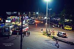
 Badiyadka Town
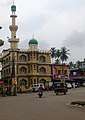 Juma Masjidh
 Navajivana HSS Perdala
See also
References
- ↑ "Census of India : Villages with population 5000 & above". Registrar General & Census Commissioner, India. Archived from the original on 8 December 2008. Retrieved 2008-12-10.
- ↑ http://www.ceo.kerala.gov.in/pdf/BLO/bloksd.pdf
- 1 2 Welcome to the Indiapost Website
- ↑ higher secondary schools in kasargode district kerala Archived 2013-01-22 at Archive.is
- ↑ Higher Secondary Schools - Kasaragod :: STATE OF KERALA :: The Ultimate Destination of Kerala Information Archived 2013-08-27 at the Wayback Machine.