Badger Mountain (Douglas County, Washington)
| Badger Mountain | |
|---|---|
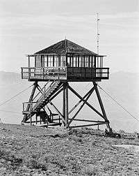 Fire lookout on top of Badger Mountain | |
| Highest point | |
| Elevation | 4,262 ft (1,299 m) NAVD 88[1] |
| Prominence | 2,674 ft (815 m) [2] |
| Coordinates | 47°35′02″N 120°10′46″W / 47.583751278°N 120.179431142°WCoordinates: 47°35′02″N 120°10′46″W / 47.583751278°N 120.179431142°W [1] |
| Geography | |
 Badger Mountain | |
| Parent range | Columbia River Plateau |
| Topo map | USGS Orondo |
Badger Mountain is a mountain in Douglas County in the U.S. state of Washington. It is the highest point in Douglas County[2] and is located east of the Columbia River and northeast of Wenatchee. Badger Mountain is part of the Columbia Plateau.
The Badger Mountain Ski Area is located on the mountain's northeastern flank.
References
- 1 2 "Ski". NGS data sheet. U.S. National Geodetic Survey. Retrieved 2010-12-29.
- 1 2 "Badger Mountain, Washington". Peakbagger.com. Retrieved 2008-10-02.
External links
- "Badger Mountain". Geographic Names Information System. United States Geological Survey.
- "Badger Mountain". SummitPost.org. Retrieved 2011-05-07.
This article is issued from
Wikipedia.
The text is licensed under Creative Commons - Attribution - Sharealike.
Additional terms may apply for the media files.