Bà Lụa Islands
| Native name: Quần đảo Bà Lụa | |
|---|---|
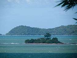 An islet of Bà Lụa Islands | |
 Bà Lụa Islands Position of Bà Lụa Islands | |
| Geography | |
| Location | Gulf of Thailand |
| Coordinates | 10°09′N 104°32′E / 10.150°N 104.533°ECoordinates: 10°09′N 104°32′E / 10.150°N 104.533°E |
| Total islands | 34 or 42 |
| Major islands | Hòn Heo |
| Highest point | 102[1] or 113 meters[2] (335 or 371 feet) on Hòn Heo |
| Administration | |
|
Vietnam | |
| Province | Kiên Giang |
| District | Kiên Lương |
| Commune | Sơn Hải |
Bà Lụa Islands (Vietnamese: Quần đảo Bà Lụa) is an archipelago located in the Gulf of Thailand. It constitutes Sơn Hải Commune of Kiên Lương District, Kiên Giang Province, Vietnam. The archipelago is known as "(Small) Ha Long of the South".
Etymology
There are several different interpretations to the name of the islands. Some sources explain that Bà Lụa is the Chinese Vietnamese wife of an influential Frenchman coming here to exploit the area; since all of related legal papers were in her name, the islands was named Bà Lụa.[3][4] Anh Dong (2010) claims that Bà Lụa ("Lady Silk") is the name of a female general in charge of military logistics who established a silk mill on the islands in order to supply Nguyễn Trung Trực's militia force.[2] Another source says that around 1858, a feudal mandarin married a beautiful and gentle wife who wanted to stay away from the officialdom and eventually settled on the islands. Every day she raised silkworms and wove silk, so the islands has been called Bà Lụa ever since.[5]
Geography
The archipelago, formed from lower-mid Paleozoic sedimentary rocks,[1] consists of about 34[1] (or 42[2]) islands spreading out over a 70-square-kilometer water area,[1] among which Hòn Heo is the largest entity. Apart from Hòn Heo, none of the rest have a highest point exceeding 100 metres (330 ft). The most populous islands are Hòn Heo, Hòn Ngang and Hòn Nhum.[2] The sea area around the archipelago is shallow, and in many places, people can even walk from island to island during low tide.[4]
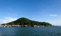
Hòn Heo (literally "Pig Island") is the largest island of Bà Lụa. It is approximately 7 kilometres (4.3 mi) in circumference and has an area of 1.5 km2 (0.6 sq mi).[6] Its name originates from the fact that the French built a piggery on the island in 1918 (Anh Dong, 2010).[7] Here lies the People's Committee Head Office of Son Hai Commune.
- Incomplete list of islands[8]
|
|
Administrative history
- On 14 January 1983, Kiên Hải District was formed with six communes including Bà Lụa Commune[9] that administered Bà Lụa Islands.
- On 27 September 1983, Bà Lụa Commune was renamed to Sơn Hải Commune (Kiên Hải District).[10]
- Since 17 August 2000, Sơn Hải Commune has been under the administration of Kiên Lương District.[11]
References
- 1 2 3 4 (in Vietnamese) "Bà Lụa". Vietnam Institute of Lexicography and Encyclopedia. Retrieved 13 May 2013.
- 1 2 3 4 Anh Dong 2010, p. 48
- ↑ (in Vietnamese) Trần Văn Linh (20 June 2011). "Thử làm "ROBINSON" Tour du lịch chỉ có ở Kiên Giang". Kien Giang Department of Culture, Sports and Tourism's Website. Retrieved 14 May 2013.
- 1 2 (in Vietnamese) Đặng Hoàng Thám (30 June 2011). "Quần đảo Bà Lụa trong vịnh Hà Tiên". Saigon Times Online. Retrieved 14 May 2013.
- ↑ (in Vietnamese) KG. "Đảo Bà Lụa". Ministry of Culture, Sports and Tourism of Vietnam's Website. Archived from the original on 26 September 2013. Retrieved 14 May 2013.
- ↑ (in Vietnamese) Đăng Khoa (7 August 2008). "Đến thủ phủ "vịnh Hạ Long phương Nam"". Tuổi trẻ online. Retrieved 14 May 2013.
- ↑ Anh Dong 2010, p. 49
- ↑ (in Vietnamese) "Bản đồ hành chính. Phần bản đồ hành chính tỉnh Kiên Giang, huyện Kiên Lương". Vietnam Government Web Portal. Archived from the original on 14 March 2013. Retrieved 13 May 2013.
- ↑ (in Vietnamese) "Quyết định của Hội đồng Bộ trưởng số 4/HĐBT ngày 14 tháng 1 năm 1983 về việc thành lập huyện Kiên Hải thuộc tỉnh Kiên Giang". Ministry of Justice's Portal (Vietnam). Archived from the original on 25 September 2013. Retrieved 13 May 2013.
- ↑ (in Vietnamese) "Quyết định của Hội đồng Bộ trưởng số 107-HĐBT ngày 27-9-1983 về việc phân vạch địa giới một số xã, phường và thị trấn Kiên Lương thuộc tỉnh Kiên Giang". Cơ sở dữ liệu Luật Việt Nam. Retrieved 13 May 2013.
- ↑ (in Vietnamese) "Nghị định số 33/2000/NĐ-CP của Chính phủ : Điều chỉnh địa giới hành chính huyện Kiên Hải và huyện Kiên Lương tỉnh Kiên Giang". Vietnam Government Web Portal. Retrieved 13 May 2013.
| Wikimedia Commons has media related to Bà Lụa Islands. |
Bibliography
- Anh Dong (2010), Sổ tay địa danh Kiên Giang, Hanoi National University Publishing House, ISBN 978-604-62-0291-2 (in Vietnamese)
External links
- Cruising Ba Lua Archipelago, 31 August 2011, Saigon Times Online
- Satellite image of Hòn Heo (Bà Lụa Islands), Google Maps