Aylestone Meadows
| Aylestone Meadows | |
|---|---|
 | |
| Type | Local Nature Reserve |
| Location | Leicester |
| OS grid | SK 571 015 |
| Area | 8.8 hectares |
| Managed by | Leicester City Council |
Aylestone Meadows is an 8.8 hectare Local Nature Reserve in Leicester. It is owned and managed by Leicester City Council.[1][2]
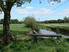
It is Leicester's largest nature reserve[3][4] situated on the floodplains of the River Soar and River Biam[5] along with several locks of the Grand Union Canal. It has a high wildlife conservation value, and has trails that are popular venue with hikers,[6] families on outings, dog walkers[7] and cyclists.[8] Many species of plant and wildlife live amongst the patchwork of flood meadows, woodland and wetlands 1.6 miles from the city centre.
Two hundred and fifty thousand years after the Ice Age, the River Soar followed the course of the River Bytham and is now one of the primary sources of the occasional flooding of the meadows. It is home to bird and wildlife together with rare[9] and common flora.[10][11]
A medieval packhorse bridge provides evidence of trade and previous populations. As this area was the site of floodplains, resulting in fertile land and good grazing areas, a settlement grew from prehistoric times to become the village of Aylestone. The construction of the Packhorse Bridge from local granite enabled transportation of goods across an area prone to flooding and includes several passing areas.[12][13]
References
| Wikimedia Commons has media related to Aylestone Meadows. |
- ↑ "Aylestone Meadows". Local Nature Reserves. Natural England. 23 March 2015. Retrieved 10 August 2017.
- ↑ "Map of Aylestone Meadows". Local Nature Reserves. Natural England. Retrieved 10 August 2017.
- ↑ "Meadows have Leicester's 'most extensive' area of wildlife". 7 February 2012.
- ↑ Leicester (England). City Planning Department (1989). Leicester ecology strategy. Leicester City Council. ISBN 978-0-901675-54-5. (various pages)
- ↑ "Environment Agency - Risk of Flooding from Rivers and Sea".
- ↑ Paul Biggs (1995). Waterway Walks in Leicestershire and Rutland. Sigma Leisure. pp. 67–. ISBN 978-1-85058-442-1.
- ↑ "Rivers polluted near Aylestone Meadows as old sewage tank fails". Leicester Mercury, July 24, 2014 By Samantha Fisher
- ↑ "Aylestone Meadows - NatureSpot".
- ↑ "Aylestone Meadows survey report available now - Leicestershire & Rutland Wildlife Trust".
- ↑ "Aylestone Meadows - Leicester's Hidden Countryside". 1 September 2009.
- ↑ http://www.lrwt.org.uk/media/uploads/news/am-publicreport.pdf retrieved 10/10/2014
- ↑ Aylestone Meadows by R N Hutchinson
- ↑ Jack Simmons (1974). Leicester Past and Present: Modern city, 1860-1974. Eyre Methuen. ISBN 978-0-413-30890-0.