Avalon, Saskatoon
| Avalon | |
|---|---|
| Neighbourhood | |
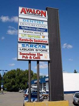 Avalon Shopping Centre | |
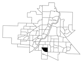 Avalon location map | |
| Coordinates: 52°5′48″N 106°39′28″W / 52.09667°N 106.65778°WCoordinates: 52°5′48″N 106°39′28″W / 52.09667°N 106.65778°W | |
| Country |
|
| Province |
|
| City | Saskatoon |
| Suburban Development Area | Nutana |
| Neighbourhood | Avalon |
| Annexed | 1910-1919 |
| Construction | 1946-1970 |
| Government | |
| • Type | Municipal (Ward 7) |
| • Administrative body | Saskatoon City Council |
| • Councillor | Mairin Loewen |
| Area | |
| • Total | 1.46 km2 (0.56 sq mi) |
| Population (2007) | |
| • Total | 3,214 |
| • Average Income | $65,000 |
| Time zone | UTC-6 (UTC) |
| Website | Avalon Community Association |
Avalon is a mostly residential neighbourhood located in south-central Saskatoon, Saskatchewan, Canada. It is a suburban subdivision, consisting mostly of low-density, single detached dwellings. As of 2007, the area is home to 3,214 residents. The neighbourhood is considered a middle-income area, with an average family income of $65,000, an average dwelling value of $168,444 and a home ownership rate of 77.3%.[1] According to MLS data, the average sale price of a home as of 2013 was $352,359.[2]
History
Most of the land for the neighbourhood was annexed by the city between 1910 and 1919, with the remaining southern piece annexed between 1960 and 1969.[3] A 1913 map shows that the present-day Avalon area overlaps three registered subdivisions of the day: Avalon in the northwest, Pacific Addition in the east and railway stock yards in the south.[4] Home construction, however, did not begin in earnest until after World War II.[1] The layout of the streets reflects the changing urban planning philosophies of the day as the land was developed. The north part of the neighbourhood follows a traditional grid pattern. By the 1950s, the design of residential neighbourhoods used a modern system of curving residential streets, feeding into collector roads that connected to arterial roads. Thus, the southern part of the neighbourhood follows this design practice.[5]
John Lake School was opened in 1958.[6] Georges Vanier School was opened that same year, and renovated in 1963.[7]
Residential build-out in Avalon was mostly completed by the late 1960s, however some additional residential development occurred south of Glasgow Street and west of Clarence Avenue in the mid-1990s, along with some limited remnant development west of Melrose Avenue in the 1980s. As noted below, plans for the southwest extension of Circle Drive initially caused some concern; construction of an interchange at Clarence Avenue and Circle, in the planning since the 1960s, was completed by the late 2000s, facilitating resident access to the freeway and to the Stonebridge commercial area to the southeast.
Government and politics
Avalon exists within the federal electoral district of Saskatoon—Grasswood. It is currently represented by Kevin Waugh of the Conservative Party of Canada, first elected in 2015.[8]
Provincially, the neighbourhood is within the constituency of Saskatoon Eastview. It is currently represented by Corey Tochor of the Saskatchewan Party, first elected in 2011.[9]
In Saskatoon's non-partisan municipal politics, Avalon lies within ward 7. It is currently represented by Councillor Mairin Loewen, who was elected to city council in a 2011 by-election.[10]
Institutions
Education
| Georges Vanier Catholic Fine Arts School | |
|---|---|
.jpg) | |
| Location | |
|
820 Wilson Crescent Saskatoon, Saskatchewan, S7J 2M4 Canada | |
| Information | |
| Type | Elementary, Fine Arts focus |
| Religious affiliation(s) | Catholic |
| Opened | 1958[11] |
| School board | Greater Saskatoon Catholic Schools |
| Principal | Laura Cey |
| Vice Principal | Chad Gusikoski |
| Grades | Kindergarten to Grade 8 |
| Enrollment | 404[12] (2017) |
| Education system | Separate |
| Language | English |
| Feeder to | Holy Cross High School |
| Website | Georges Vanier Catholic Fine Arts School |
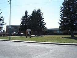
| John Lake School | |
|---|---|
 | |
| Location | |
|
2606 Broadway Avenue Saskatoon, Saskatchewan, S7J 0Z6 Canada | |
| Information | |
| Type | Elementary |
| Opened | 1958 |
| School board | Saskatoon Public School Division |
| Principal | Kendall Pierce |
| Vice Principal | Theresa Dolgopol |
| Enrollment | 201[12] (2017) |
| Education system | Public |
| Feeder to | Aden Bowman Collegiate |
| Website | John Lake School |
- Georges Vanier Catholic Fine Arts School - separate (Catholic) elementary, part of Greater Saskatoon Catholic Schools[13] Originally opened in 1958 as Christ the King School, it was renamed in honor of Georges Vanier in 1967. In 1979, it became the first designated fine arts school in Saskatchewan.[14] The school began major expansion and renovation during 2014 which was completed by the fall of 2015.[15]
- John Lake School - public elementary school, part of the Saskatoon Public School Division.[16] The school was constructed in 1959.[6]
- Avalon is also served by Aden Bowman Collegiate, located a few blocks to the north of John Lake School.
Parks and recreation
- C.P. Seeley Park (1.3 acres)
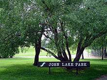
- John Lake Park (4.1 acres)
- Avalon Park (4.2 acres)
The Avalon Community Association exists to represent the educational, recreational, and social needs of residents, to promote a sense of community and enhance quality of life in the area.[17]
Public services
Avalon is a part of the east division of the Saskatoon Police Service's patrol system.[18] Saskatoon Fire & Protective Services' east division covers the neighbourhood.[19] Transit services to Avalon are provided by Saskatoon Transit on routes No. 6 (Clarence - Broadway) and 13 (Lawson - Exhibition).[20]
Commercial
The main commercial development is the Avalon Shopping Centre, a strip mall located on the corner of Broadway Avenue and Cascade Street. There are also two small commercial areas along Ruth Street: one between Lorne and Vernon Avenues, and another at Melrose Avenue. In addition, there are 40 home-based businesses in the neighbourhood. It is also separated by an interchange from the Stonebridge "big-box" shopping centre to the immediate southeast.
Location
Avalon is located within the Nutana Suburban Development Area. It is bounded by Ruth Street to the north, Circle Drive to the south, Idylwyld Drive to west, and Clarence Avenue to the east. Roads are laid in a grid fashion in the north part of the neighbourhood, while the south part features crescents and cul-de-sacs.
Vernon Avenue is a local oddity. On maps it is a one-block long one-way street for northbound traffic between Bute and Ruth Streets. It actually begins at Bute Street as the back alley for houses along McPherson Avenue to the east. It then merges with the Idylwyld Freeway offramp to become a true road until terminating at Ruth Street. St. George Avenue in the neighbouring Exhibition neighbourhood is similarly used as the southbound exit from the Idylwyld Freeway to Ruth Street. The combination of houses and exiting freeway traffic makes this type of street a rarity in Saskatoon.
Early planning for the southwestern extension of Circle Drive led to some concerns as early concepts for the proposed flyover interchange with Idylwyld Freeway would have required demolition of many homes on or near Glasgow Street. The final design, which opened to traffic on July 31, 2013, sacrificed some greenspace in the southwest corner of the community, and the construction of sound attenuation fencing, but otherwise required no home demolition.
References
- 1 2 "Avalon neighbourhood profile" (PDF). City of Saskatoon - City Planning Branch. 2007. Archived from the original (PDF) on 2012-03-12. Retrieved 2010-01-29.
- ↑ "Avalon". Saskatoon Realty. Retrieved 2013-10-26.
- ↑ Community Services Department (Spring 2006). City Planning Branch, ed. "Populace". 8 (1). City of Saskatoon: 5.
- ↑ O'Brien, Jeff; Ruth W. Millar; William P. Delainey (2006). Roberta Coulter, ed. Saskatoon: A History in Photographs. Coteau Books. p. 31. ISBN 978-1-55050-336-4.
- ↑ "Key to Landmarks". A View From Above. Saskatchewan Council for Archives and Archivists. 2000. Retrieved 2010-01-08.
- 1 2 Blashill, Lorraine (1982). "From a Little Stone School... History of Saskatoon Public Schools". Saskatoon, SK: Modern Press Ltd.: 100.
- ↑ French, Janet (September 3, 2009). "School copes with enrolment boom". The StarPhoenix. CanWest. Retrieved 2010-01-20.
- ↑ Current Members of Parliament, retrieved 2017-04-16
- ↑ Legislative Assembly of Saskatchewan - Members of the Legislative Assembly, retrieved 2017-04-16
- ↑ City Councillors - Saskatoon.ca, retrieved 2017-04-16
- ↑ Celebrating a Century of Faith and Learning - A History of Saskatoon's Catholic Schools. Greater Saskatoon Catholic Schools. 2015. p. 189. ISBN 978-0-9947443-0-2.
- 1 2 Active List of Saskatchewan Schools/Programs (PDF), retrieved 2018-02-10
- ↑ "Georges Vanier School". Greater Saskatoon Catholic Schools. Retrieved 2015-07-04.
- ↑ Our History (PDF), retrieved 2015-07-01
- ↑ "GSCS: Construction Overview". Greater Saskatoon Catholic Schools. Retrieved 2015-07-04.
- ↑ "John Lake School". Saskatoon Public School Division. Retrieved 2015-07-04.
- ↑ "Avalon Community Association". City of Saskatoon - Leisure Services & Community Development. Archived from the original on 2011-03-09. Retrieved 2010-01-10.
- ↑ "East Division". Saskatoon Police Service. Archived from the original on 2011-07-06. Retrieved 2009-09-04.
- ↑ "Divisions - East". City of Saskatoon - Fire and Protective Services. Archived from the original on 2011-07-17. Retrieved 2010-01-20.
- ↑ "Routes and Services". City of Saskatoon - Transit Services. Archived from the original on 25 January 2010. Retrieved 2010-01-20.
External links
| Wikimedia Commons has media related to Avalon, Saskatoon. |
Places adjacent to Avalon, Saskatoon | |
|---|---|