Aurelle-Verlac
| Aurelle-Verlac | ||
|---|---|---|
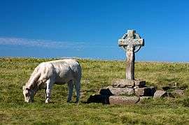 Wayside Cross in Aurelle-Verlac | ||
| ||
 Aurelle-Verlac Location within Occitanie region  Aurelle-Verlac | ||
| Coordinates: 44°30′25″N 3°00′29″E / 44.5069°N 3.0081°ECoordinates: 44°30′25″N 3°00′29″E / 44.5069°N 3.0081°E | ||
| Country | France | |
| Region | Occitanie | |
| Department | Aveyron | |
| Arrondissement | Rodez | |
| Canton | Lot et Palanges | |
| Intercommunality | - | |
| Government | ||
| • Mayor (-) | - | |
| Area1 | 54.68 km2 (21.11 sq mi) | |
| Population (2013)2 | 163 | |
| • Density | 3.0/km2 (7.7/sq mi) | |
| Time zone | UTC+1 (CET) | |
| • Summer (DST) | UTC+2 (CEST) | |
| INSEE/Postal code | 12014 /12130 | |
| Elevation |
500–1,461 m (1,640–4,793 ft) (avg. 1,000 m or 3,300 ft) | |
|
1 French Land Register data, which excludes lakes, ponds, glaciers > 1 km2 (0.386 sq mi or 247 acres) and river estuaries. 2 Population without double counting: residents of multiple communes (e.g., students and military personnel) only counted once. | ||
Aurelle-Verlac (Occitan: Aurela Verlac) is a former commune in the Aveyron department in the Occitanie region of southern France. On 1 January 2016, it was merged into the new commune of Saint-Geniez-d'Olt-et-d'Aubrac.[1]
The inhabitants of the commune are known as Aurellacois or Aurellacoises.[2]
Geography
Aurelle-Verlac is located in the Massif Central in Aubrac some 60 km east of Decazeville and 70 km south-east of Aurillac with the eastern border of the commune being the border between Aveyron and Lozère departments. Access to the commune is by road D503 from Saint-Geniez-d'Olt in the south which goes north through the village and most of the length of the commune before going west to join the D219 west of the commune. Apart from the village there are the hamlets of Crespiac, Verelaguet, Les Mazes, La Frassinede, Naves d'Aubrac, La Molière, Moncan, Rieuzens, Bernie, Les Caps, and Les Ginestes. The commune is mainly deep valleys where boraldes flow down to the Lot. The highest point in the department is on the Signal de Mailhe-Biau in the north-east of the commune.[3] It is located in a Natura 2000 zone and is rugged with forests and high country farming.[4]
The Ruisseau de Mardonenque rises in the north and flows south down the centre of the commune gathering tributaries including the Ruisseau de Monette, the Ravin de Placaus, the Ravin des Rives, the Ravin de la Coste, the Ravin de la Ligue, and the Ruisseau de Rioubasset, which forms the south-eastern border, before continuing south to join the Lot near Saint-Geniez-d'Olt. The Ruisseau de Bonance also rises in the north of the commune and flows south towards the eastern side of the commune forming part of the eastern border before continuing south to join the Lot near Pomayrols. On the western side of the commune the Merdanson forms the western border of the commune as it flows south to join the Lot near Cabanac. The Ruisseau de Rioudis and the Ruisseau de Mandialou both rise in the commune and join the Merdanson on the western border.[4]
Neighbouring communes and villages[4]
Places adjacent to Aurelle-Verlac | |
|---|---|
Heraldry
.png) |
These arms are Canting arms with the gold referring to the commune name and the silver to silver mines.
Blazon: |
Administration
List of Successive Mayors[5]
| From | To | Name | Party | Position |
|---|---|---|---|---|
| 1793 | 1797 | Pierre Jean Duarn | ||
| 1798 | 1801 | Jean Claude Galdemar | ||
| 1802 | 1816 | Jean Bach | ||
| 1816 | 1822 | Antoine Niel | ||
| 1822 | 1827 | Jean Pierre Auguy | ||
| 1827 | 1831 | François Joseph Rauquayrol | ||
| 1831 | 1849 | Jean Pierre Auguy | ||
| 1849 | 1851 | Jacques Poujol | ||
| 1852 | 1857 | Jean Pierre Auguy | ||
| 1857 | 1864 | Jean Antoine Alazard | ||
| 1864 | 1870 | Baptiste Mounie | ||
| 1870 | 1878 | Jean Pierre Auguy | ||
| 1878 | 1884 | Etienne Marcilhac | ||
| 1884 | 1884 | Louis Alazard | ||
| 1884 | 1902 | Louis Miquel | ||
| 1902 | 1919 | Louis Alazard |
- Mayors from 1919
| From | To | Name | Party | Position |
|---|---|---|---|---|
| 1919 | 1947 | Antoine Alazard | ||
| 1947 | 1965 | Théophile Auguy | ||
| 1965 | 1971 | Jean Foulquier | ||
| 1971 | 1983 | Jean Vialard | ||
| 1983 | 2008 | Paul Garces | ||
| 2008 | 2020 | Jean-Pierre Niel |
(Not all data is known)
Demography
In 2010 the commune had 165 inhabitants. The evolution of the number of inhabitants is known from the population censuses conducted in the commune since 1793. From the 21st century, a census of communes with fewer than 10,000 inhabitants is held every five years, unlike larger towns that have a sample survey every year.[Note 1]
| 1793 | 1800 | 1806 | 1821 | 1831 | 1836 | 1841 | 1846 | 1851 |
|---|---|---|---|---|---|---|---|---|
| 1,810 | 1,696 | - | - | - | - | - | 1,068 | 1,085 |
| 1856 | 1861 | 1866 | 1872 | 1876 | 1881 | 1886 | 1891 | 1896 |
|---|---|---|---|---|---|---|---|---|
| 1,065 | 1,025 | 1,075 | 1,007 | 1,029 | 1,022 | 1,048 | 990 | 971 |
| 1901 | 1906 | 1911 | 1921 | 1926 | 1931 | 1936 | 1946 | 1954 |
|---|---|---|---|---|---|---|---|---|
| 896 | 903 | 832 | 726 | 705 | 653 | 614 | 494 | 478 |
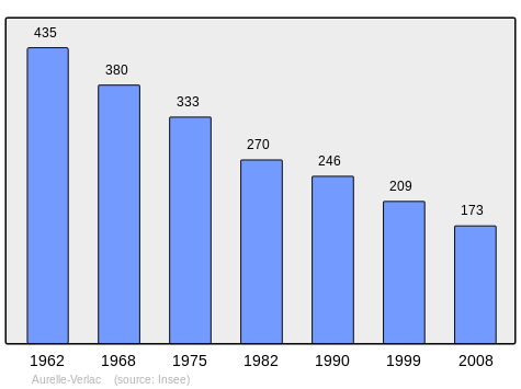
| 1962 | 1968 | 1975 | 1982 | 1990 | 1999 | 2006 | 2010 | - |
|---|---|---|---|---|---|---|---|---|
| 435 | 380 | 333 | 270 | 246 | 209 | 182 | 165 | - |
Sources : Ldh/EHESS/Cassini until 1962, INSEE database from 1968 (population without double counting and municipal population from 2006)
Culture and heritage
Civil heritage
- The Fortified Farm of Aubignac[6]
Religious heritage
The commune has two religious buildings that are registered as historical monuments:
- The Church of Saint-Jacques de Verlac (11th century)


- The Church of Saint-Pierre d'Aurelle (1384)
- The Church of Saint-Martin-de-Montbon contains a Bronze Bell (1762)
- Other religious structures of interest
- The Rode Cross was erected by the lord of Peyre in 1377.
- The Berque Cross[11] is located at Les Mazes rising from the Vergnes Cross. It was built in 1531 and marked the boundary of the barony of Aurelle between the dom[Note 2] lands of Aubrac and those of the Marquis of Canilhac. On one of its faces it has an expressive though stylized virgin with child.
Bibliography
- Christian-Pierre Bedel, Sent-Ginièis, Aurela-Verlac, Pèira-Ficha, Pomairòls, Pradas, Senta-Aularia / Christian-Pierre Bedel and the inhabitants of the commune of Sent-Ginièis, Rodez, Mission départementale de la culture, 1991, Al canton collection, 230 pages, ill., cov. ill., 28 cm, ISBN 2-907279-07-6, ISSN 1151-8375, BnF 36653864f (in Occitan) (in French)
See also
External links
- Non-official Aurelle-Verlac website (in French)
- Aurelle-Verlac on Google Maps
- Aurelle-Verlac on Géoportail, National Geographic Institute (IGN) website (in French)
- Aurelle and Verlac on the 1750 Cassini Map
- Aurelle-Verlac on the INSEE website (in French)
- INSEE (in French)
Notes and references
Notes
- ↑ At the beginning of the 21st century, the methods of identification have been modified by Law No. 2002-276 of 27 February 2002 Archived 6 March 2016 at the Wayback Machine., the so-called "law of local democracy" and in particular Title V "census operations" allows, after a transitional period running from 2004 to 2008, the annual publication of the legal population of the different French administrative districts. For communes with a population greater than 10,000 inhabitants, a sample survey is conducted annually, the entire territory of these communes is taken into account at the end of the period of five years. The first "legal population" after 1999 under this new law came into force on 1 January 2009 and was based on the census of 2006.
- ↑ A name given to certain religious, particularly in the Benedictine, Carthusian, and Trappist orders.
References
- ↑ Arrêté préfectoral 6 November 2015
- ↑ Inhabitants of Aurelle-Verlac (in French)
- ↑ Aurelle-Verlac on Géoportail, National Geographic Institute (IGN) website (in French)
- 1 2 3 Google Maps
- ↑ List of Mayors of France (in French)
- ↑ The fortified farm of Aubignac (in French)
- ↑ Ministry of Culture, Mérimée PA00093959 Church of Saint-Jacques de Verlac (in French)
- ↑ Ministry of Culture, Palissy PM12000009 Bronze bell (in French)
- ↑ Ministry of Culture, Mérimée PA00093958 Church of Saint-Pierre d'Aurelle (in French)
- ↑ Ministry of Culture, Palissy PM12000010 Bronze bell (in French)
- ↑ Berque Cross (in French)
| Wikimedia Commons has media related to Aurelle-Verlac. |