Attahas, Katwa
The temple of Attahas, also known as Fullora Attahas, is believed to be one of the 51 Shakti Peethas at which the body parts and jewelry of the Hindu goddess Shakti fell to Earth.[1] The goddess is so large that the lower lip is about 15 to 18 feet wide. The temple is a site of Hindu pilgrimage throughout the year. December is a particularly popular time for visitors to picnic at the site.

Location
The temple is located in the Nirol gram panchayat in the Katwa subdivision of the Purba Bardhaman district of West Bengal. It is about 5 km from the Nirol bus stand and beside the Ishani river (locally known as Kandor river).
Another view of Attahas is from Attahas village, near Labhpur station, on the Ahmedpur Katwa Railway line.[2]
More information about Attahas Shaktipeeth can be found on the official website https://attahas.in.[3]
The Attahas shrine as a Shakti Peeth
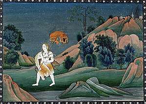
Attahas Sanskrit comes from Atta and Hasa (laughter) meaning extreme loud laughter. The temple of Attahas is considered as a Shakti Peetha. Shakti Peethas are shrines that are prominent places of worship for the Shakta sect (Shaktism) of Hinduism. These are places where the body parts of Sati Devi's corpse fell when Lord Shiva carried her body after her death. The place where her body parts fell were enshrined by the divine presence of Shakti. The story of origin is the mythology of Daksha yaga and Sati's self immolation. The Lips of Sati Devi is said to have fallen here. Each Shakti Peetha has a name for the Shakti an Kalabhairava associated with the temple. The Shakti of the Attahas shrine is addressed as Phullara and the Kalabhairava as Vishvesh.[4] There are 51 Shakti Peeth linking to the 51 alphabets in Sanskrit.
References
- ↑ "Tourism". Burdwan District.
- ↑ "51 Shakti peethas - Exact locations & Travel information". Shaktipeethas.org - The Indian Spiritual Encyclopedia. July 15, 2010.
- ↑ "Official Attahas Shaktipeeth Website". Attahas.in. Kunal DUtta.
- ↑ "Kottiyoor Devaswam Temple Administration Portal". Kottiyoor Devaswam. Retrieved July 20, 2013.
Coordinates: 23°43′10.23″N 88°1′31.09″E / 23.7195083°N 88.0253028°E