Athani, Ernakulam
| Athani | |
|---|---|
| village | |
 | |
 Athani Location in Kerala, India  Athani Athani (India) | |
| Coordinates: 10°9′19.86″N 76°21′15.94″E / 10.1555167°N 76.3544278°ECoordinates: 10°9′19.86″N 76°21′15.94″E / 10.1555167°N 76.3544278°E | |
| Country |
|
| State | Kerala |
| District | Ernakulam |
| Talukas | Ernakulam |
| Government | |
| • Type | Panchayati raj (India) |
| • Body | Gram panchayat |
| Languages | |
| • Official | Malayalam, English |
| Time zone | UTC+5:30 (IST) |
| PIN | 683585 |
| Vehicle registration | KL-41 |
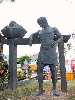
Statue at Athani Junction
Athani is a village in Nedumbasery Panchayat near Angamaly in Eranakulam district in the Indian state of Kerala. This village is situated in the National Highway 544. Cochin International Airport road is starting from here.
Athani is situated 6 km away from angamaly,[1] 5 km away from Cochin International Airport,[2] 8.2 km away from Aluva and 2.1 km away from Chengamand.
Kerala Agro Machinery Corporation Limited is situated at Athani.[3] Kerala Ayurveda Limited is also have an office, factory and herbel gardern here.
Mar Athanasius High School Athani
St Francis Assisi School and Mar Athanasius Higher Secondary School are the educational institutions working here.
Temples
- Veerahanuman Kovil
- Nedumbassery Sree DurgaDevi Temple
- Mukundapuram Sree Maha Vishnu Temple
Churches
- St. Antony's Latin Catholic Church
- St Francis Assisi Church
- St. George Jacobite Syrian Church
- St. Mary's Chapel
- The Pentecostal Mission Church
- Holy Family Convent Daughters Of Nazareth
Nearby Places
- Chengamanad
- Kaprassery
- Karakkattukunnu
- Mekkad
- Nedumbassery
- Neduvannoor
- Cheriya Vappalassery
References
- ↑ "Athani (i)". www.keralatourism.org. Retrieved 2018-09-02.
- ↑ "Cochin International Airport (COK) – Transport". www.cochinairport.com. Retrieved 2018-09-02.
- ↑ "Kerala Agro Machinery Corporation Ltd". kerala.gov.in. Retrieved 2018-09-02.
This article is issued from
Wikipedia.
The text is licensed under Creative Commons - Attribution - Sharealike.
Additional terms may apply for the media files.