At-Bashy
| At-Bashy Ат-Башы | |
|---|---|
 At-Bashy | |
| Coordinates: 41°10′12″N 75°48′0″E / 41.17000°N 75.80000°ECoordinates: 41°10′12″N 75°48′0″E / 41.17000°N 75.80000°E | |
| Country | Kyrgyzstan |
| Region | Naryn Region |
| District | At-Bashy District |
| Population (2009)[1] | |
| • Total | 10,764 |
| de jure population | |
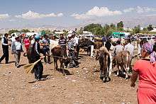
Livestock market in At-Bashy
At-Bashy is a village in the Naryn Region of Kyrgyzstan, about 35km southwest of Naryn on the main highway to the Torugart Pass. It is the seat of At-Bashi District. The At-Bashy Range to the south extends to Lake Chatyr-Kul. The At-Bashy River comes in from the east and then runs northwest through a gorge in the Baybiche-Too range to join the Naryn River near Dostuk. It is the last considerable settlement before the Chinese border. The highway, built in 1906, runs southwest between the Baybache-Too and At-Bashy ranges before turning south and then east to reach the pass. As of 2009 it has a population of 10,764.[1]
References
- 1 2 "2009 population census of the Kyrgyz Republic: Naryn Region" (PDF). Archived from the original (PDF) on 21 March 2012. Retrieved 2016-06-15.
Sources
- World Gazetteer: Kyrgyzstan – World-Gazetteer.com
This article is issued from
Wikipedia.
The text is licensed under Creative Commons - Attribution - Sharealike.
Additional terms may apply for the media files.