Aspronisi
| Nickname: "White Island" | |
|---|---|
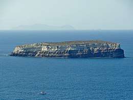 Photo of Aspronisi. The contrast between lighter pumice and darker volcanic rock can be seen. | |
 Aspronisi Location in Greece | |
| Geography | |
| Location | Mediterranean Sea |
| Coordinates | 36°23′00″N 25°20′52″E / 36.38333°N 25.34778°ECoordinates: 36°23′00″N 25°20′52″E / 36.38333°N 25.34778°E |
| Total islands | 1 |
| Area | 0.14 km2 (0.054 sq mi) |
| Administration | |
Aspronisi (Greek: Ασπρονήσι) is an uninhabited island lying within the Santorini caldera.[1] The island was originally formed by the massive Minoan eruption in the 2nd millennium BC, after which it was gradually built up by successive volcanic activity.[2] The name Aspronisi, which means 'White Island' in Greek, is derived from the island being partially composed of white pumice.[3][4]
Formation
Aspronisi was formed through the gradual volcanic activity in the Santorini caldera, which itself is composed of four distinct shield volcanoes.[5] The island was formed along with the current Santori caldera during a massive eruption in the 2nd millennium BC that expelled 14 cubic miles (60 km3 ) of dense rock. Aspronisi was briefly a submarine volcano before the force of the eruption pushed the islet above the surface, after which dense layers of pumice and tephra ejected from the volcano covered the island. These deposits eventually solidified into the pale white deposits that give Aspronisi it's moniker of the "White Isle".[4] The base of the island is composed of black lava rock, and the island is connected to the larger islands of Therasia and Santorini by the submerged outer edge of the Santorini caldera.[6]
Geography
The island has an area of 0.14 square kilometers. Its dimensions are 650 meters long by 200 meters wide.[4][3] The island is dominated by steep cliffs, making landings difficult, though two pebble beaches and a small anchorage exist on the islet.[3] The top of the island takes the form of a flat plateau.
Habitation
Aspronisi is currently uninhibited, though sparse plant life can be found on the island.[3] The island is a nesting ground for some species of migratory birds.[7]

References
- ↑ Anatomy of an Eruption. Floyd W. McCoy and Grant Haiken. Archaeology, Vol. 43, No. 3 (MAY/JUNE 1990), pp. 42-49 Published by: Archaeological Institute of America Stable URL: http://www.jstor.org/stable/41765836 Accessed: 21-04-2018 03:45 UTC
- ↑ "Santorini Decade Volcano, Greece". www.decadevolcano.net. Retrieved 2018-04-21.
- 1 2 3 4 "The island of Aspronisi or Strogilo near Santorini in the Cyclades in Greece, Nea Kameni and Paleo Kameni". www.angelfire.com. Retrieved 2018-04-21.
- 1 2 3 Schönrock, Dirk / Fohrer Eberhard: Santorini. Michael Müller Verlag, 3., überarbeitete und aktualisierte Auflage, Erlangen 2006, ISBN 3-89953-320-8. p. 242
- ↑ "How Volcanoes Work - Santorini Eruption". www.geology.sdsu.edu. Retrieved 2018-04-21.
- ↑ "Santorini (Thera) Volcano". www.photovolcanica.com. Retrieved 2018-04-21.
- ↑ Sfenthourakis, Spyros; Panitsa, Maria (2012-04-01). "From plots to islands: species diversity at different scales". Journal of Biogeography. 39 (4): 750–759. doi:10.1111/j.1365-2699.2011.02639.x. ISSN 1365-2699.