Minoan eruption
| Minoan eruption | |
|---|---|
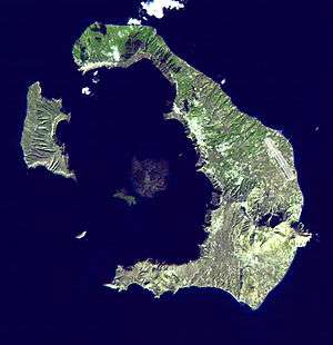 Satellite image of Thera, November 21, 2000 | |
| Volcano | Thera |
| Date |
mid 2nd millennium BCE between 1642–1540 BCE |
| Type | Plinian |
| Location |
Santorini, Minoan civilization (modern Greece) 36°25′N 25°26′E / 36.417°N 25.433°ECoordinates: 36°25′N 25°26′E / 36.417°N 25.433°E |
| VEI | 6 or 7 |
| Impact | Devastated the Minoan settlements of Akrotiri, the island of Thera and communities and agricultural areas on nearby islands, and the coast of Crete with a related earthquake or tsunami. |
 Thera | |
The Minoan eruption of Thera, also referred to as the Thera eruption, Santorini eruption, or Late Bronze Age eruption, was a major catastrophic volcanic eruption with a Volcanic Explosivity Index (VEI) of 6 or 7 and a dense-rock equivalent (DRE) of 60 km3 (14 cu mi),[1][2] Dated to the mid-second millennium BCE,[3] the eruption was one of the largest volcanic events on Earth in recorded history.[4][5][6] It devastated the island of Thera (now called Santorini), including the Minoan settlement at Akrotiri and communities and agricultural areas on nearby islands and the coast of Crete with a related earthquake and tsunami.
There are no clear ancient records of the eruption, which may have inspired certain Greek myths,[7] caused turmoil in Egypt[8][9] and been alluded to in a Chinese chronicle.
Eruption
Background
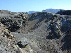
Geological evidence shows the Thera volcano erupted numerous times over several hundred thousand years before the Minoan eruption. In a repeating process, the volcano would violently erupt, then eventually collapse into a roughly circular seawater-filled caldera, with numerous small islands forming the circle. The caldera would slowly refill with magma, building a new volcano, which erupted and then collapsed in an ongoing cyclical process.[10]
Immediately before the Minoan eruption, the walls of the caldera formed a nearly continuous ring of islands with the only entrance between Thera and the tiny island of Aspronisi.[10] This cataclysmic eruption was centered on a small island just north of the existing island of Nea Kameni in the centre of the then-existing caldera. The northern part of the caldera was refilled by the volcanic ash and lava, then collapsed again.
Magnitude
Research by a team of international scientists in 2006 revealed that the Santorini event was much larger than the original estimate of 39 km3 (9.4 cu mi) of Dense-Rock Equivalent (DRE), or total volume of material erupted from the volcano, that was published in 1991.[1] With an estimated DRE in excess of 60 km3 (14 cu mi),[1][6] the volume of ejecta was approximately 100 km3 (24 cu mi).[11] If so, the eruption's Volcanic Explosivity Index was 7. The volcano ejected up to four times as much as the well-recorded eruption by Krakatoa in 1883. The Thera volcanic events and subsequent ashfall probably sterilized the island, as occurred on Krakatoa. Only the Mount Tambora volcanic eruption of 1815, Lake Taupo's Hatepe eruption around 180 CE, and perhaps the Baekdu Mountain eruption around 970 CE released more material into the atmosphere during historic times.[4][5]
Sequence
On Santorini, there is a 60 m (200 ft) thick layer of white tephra that overlies the soil clearly delineating the ground level before the eruption. This layer has three distinct bands that indicate the different phases of the eruption.[12] Studies have identified four major eruption phases, and one minor precursory tephra fall. The thinness of the first ash layer, along with the lack of noticeable erosion of that layer by winter rains before the next layer was deposited, indicate that the volcano gave the local population a few months' warning. Since no human remains have been found at the Akrotiri site, this preliminary volcanic activity probably caused the island's population to flee. It is also suggested that several months before the eruption, Santorini experienced one or more earthquakes, which damaged the local settlements.[13][14]
Intense magmatic activity of the first major phase (BO1/Minoan A)[15] of the eruption deposited up to 7 m (23 ft) of pumice and ash, with a minor lithic component, southeast and east. Archaeological evidence indicated burial of man-made structures with limited damage. The second (BO2/Minoan B) and third (BO3/Minoan C) eruption phases involved pyroclastic flow and lava fountain activity and the possible generation of tsunamis. Man-made structures not buried during Minoan A were completely destroyed. The third phase was also characterized by the initiation of caldera collapse. The fourth, and last, major phase (BO4/Minoan D) was marked by varied activity: lithic-rich base surge deposits, lahars, debris flows, and co-ignimbrite ash-fall deposits. This phase was characterized by the completion of caldera collapse, which produced megatsunamis.[16]
Geomorphology

Although the fracturing process is not yet known, the altitudinal statistical analysis indicates that the caldera had formed just before the eruption. The area of the island was smaller, and the southern and eastern coastlines appeared regressed. During the eruption, the landscape was covered by the pumice sediments. In some places, the coastline vanished under thick tuff depositions. In others, recent coastlines were extended towards the sea. After the eruption, the geomorphology of the island was characterized by an intense erosional phase during which the pumice was progressively removed from the higher altitudes to the lower ones.[17]
Volcanology
The eruption was of the Plinian type and it resulted in an estimated 30 to 35 km (19 to 22 mi) high ash plume which extended into the stratosphere. In addition, the magma underlying the volcano came into contact with the shallow marine embayment, resulting in a violent steam eruption.
The eruption also generated a 35 to 150 m (115 to 492 ft) high tsunami that devastated the north coast of Crete, 110 km (68 mi) away. The tsunami affected coastal towns such as Amnisos, where building walls were knocked out of alignment. On the island of Anafi, 27 km (17 mi) to the east, ash layers 3 m (10 ft) deep have been found, as well as pumice layers on slopes 250 m (820 ft) above sea level.
Elsewhere in the Mediterranean are pumice deposits that could have been caused by the Thera eruption. Ash layers in cores drilled from the seabed and from lakes in Turkey, however, show that the heaviest ashfall was towards the east and northeast of Santorini. The ash found on Crete is now known to have been from a precursory phase of the eruption, some weeks or months before the main eruptive phases, and it would have had little impact on the island.[18] Santorini ash deposits were at one time claimed to have been found in the Nile delta,[19] but this is now known to be a misidentification.[20][21]
Eruption dating
The Minoan eruption is a key marker for the Bronze Age chronology of the Eastern Mediterranean world. It provides a fixed point for aligning the entire chronology of the second millennium BCE in the Aegean, as evidence of the eruption is found throughout the region. Despite the evidence, the exact date of the eruption has been difficult to determine. Archaeologists have traditionally placed it at approximately 1500 BCE.[14][22] Radiocarbon dates, including analysis of an olive branch buried beneath a lava flow from the volcano that gave a date between 1627 BCE and 1600 BCE (95% confidence interval), suggest an eruption date more than a century earlier than suggested by archaeologists.[23][24][25] Thus, the radiocarbon dates and the archaeological dates are in substantial disagreement.[26] It has also been recently suggested that there may be regional variations in the calibration curve which might alter a date by up to 20 years. [27]
In 2012, one of the proponents of an archaeological date, Felix Höflmayer, argued that archaeological evidence could be consistent with a date as early as 1590 BCE, reducing the discrepancy to around 50 years.[28]
Conversely, the radiocarbon dates have been argued to be inaccurate on scientific grounds. That argument has been made, in particular, by Malcolm H. Wiener.[29][30][31] The primary problem is that 14C-deficient carbon, sourced from the environment, might easily have affected the radiocarbon dates.
Relative chronology
Archaeologists developed the Late Bronze Age chronologies of eastern Mediterranean cultures by analysing the origin of artifacts (for example, items from Crete, mainland Greece, Cyprus or Canaan) found in each archaeological layer.[32] If an artifact's origin can be accurately dated, it gives a reference date for the layer in which it is found. If the Thera eruption could be associated with a given layer of Cretan (or other) culture, chronologists could use the date of that layer to date the eruption itself. Since Thera's culture at the time of destruction was similar to the Late Minoan IA (LMIA) culture on Crete, LMIA is the baseline to establish chronology elsewhere. The eruption also aligns with Late Cycladic I (LCI) and Late Helladic I (LHI) cultures, but predates Peloponnesian LHI.[33] Archeological digs on Akrotiri have also yielded fragments of nine Syro-Palestinian Middle Bronze II (MBII) gypsum vessels.[32]
The Aegean prehistorians felt so confident about their calculations that they rejected early radiocarbon dates in the 1970s for LMI/LCI Thera, as radiocarbon suggested a date about a century earlier than the traditional dates.[34]
Pumice found at Tell el Dab'a in Egypt that matches the composition of the Thera eruption has been dated to 1540 BCE, closer to the traditionally-accepted date of Thera's eruption.[35] This pumice has been contentious since the 1990s, as it represents the most prominent supported date to differ from the old chronology.
Ice cores and tree rings
Greenland ice cores show evidence of a large volcanic eruption in 1642 ± 5 BCE, which was suggested as being associated with Santorini.[36] However, volcanic ash retrieved from an ice core does not match the expected Santorini fingerprint.[18] The late Holocene eruption of the Mount Aniakchak, a volcano in Alaska, is now believed to be the source of the minute shards of volcanic glass in the Greenland ice core.[37][38]
Another method that has been used to establish the date of eruption is tree-ring dating. Tree-ring data has shown that a large event interfering with normal tree growth in North America occurred during 1629–1628 (±65 years) BCE.[39] Evidence of a climatic event around 1628 BCE has been found in studies of growth depression of European oaks in Ireland and of Scotch pines in Sweden.[40] Bristlecone pine frost rings also indicate a date of 1627 BCE, supporting the late 1600s BCE dating.[41][42] Recent work has used radiocarbon levels in bristlecone pines and Irish oak dated from 1700 BC to 1500 BC to develop a new calibration curve which is more accurate for this period. It results in the eruption being dated to between 1600 and 1525, a time period which overlaps with the 1570-1500 date range from the archeological evidence. [43][44]Procedural changes in how ice cores are interpreted would bring that data more in line with the dendrochronological numbers.[45]
Climatic effects
Hydrogeologist Philip LaMoreaux asserted in 1995 that the eruption caused significant climatic changes in the eastern Mediterranean region, Aegean Sea and much of the Northern Hemisphere,[46] but that was forcefully rebutted by volcanologist David Pyle a year later.[47]
Around the time of the radiocarbon-indicated date of the eruption, there is evidence for a significant climatic event in the Northern Hemisphere like failure of crops in China (see below) and evidence from tree rings, cited above: bristlecone pines of California; bog oaks of Ireland, England, and Germany; and other trees in Sweden. The tree rings date the event to 1628 (±65 years) BCE.[39][40]
Historical impact
Minoan civilization
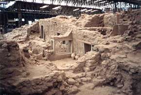
The eruption devastated the nearby Minoan settlement at Akrotiri on Santorini, which was entombed in a layer of pumice.[48] It is believed that the eruption also severely affected the Minoan population on Crete, but the extent of the impact is debated. Early theories proposed that ashfall from Thera on the eastern half of Crete choked off plant life, causing starvation of the local population.[49] However, after more thorough field examinations, the theory has lost credibility, as it has been determined that no more than 5 mm (0.20 in) of ash fell anywhere on Crete.[50] Other theories have been proposed based on archeological evidence found on Crete indicating that a tsunami, likely associated with the eruption, impacted the coastal areas of Crete and may have devastated the Minoan coastal settlements.[51][52][53][54] Another theory is that much of the damage done to Minoan sites resulted from a large earthquake and the fires it caused, which preceded the Thera eruption.[55][56]
Significant Minoan remains have been found above the Late Minoan I era Thera ash layer and tsunami level, and it is unclear whether the effects were enough to trigger the downfall of the Minoan civilization. Some sites were abandoned or settlement systems significantly interrupted in the immediate aftermath of the eruption.[54] As the Minoans were a sea power and depended on ships for their livelihood, the Thera eruption likely caused significant economic hardship to the Minoans. Whether the effects were enough to trigger the downfall of the civilization is intensely debated. The Mycenaean conquest of the Minoans occurred in Late Minoan II period. The Mycenaeans were a military civilization. Using their functional navy and a well-equipped army, they were capable of an invasion. Mycenaean weaponry has been found in burials on Crete. That demonstrates Mycenaean military influence not many years after the eruption.[57] Many archaeologists speculate that the eruption caused a crisis in Minoan civilization, making them vulnerable to conquest by the Mycenaeans.[52]
Chinese records
A volcanic winter from an eruption in the late 17th century BCE has been claimed by some researchers to correlate with entries in later Chinese records documenting the collapse of the semi-legendary Xia dynasty in China. According to the Bamboo Annals, the collapse of the dynasty and the rise of the Shang dynasty, approximately dated to 1618 BCE, were accompanied by "yellow fog, a dim sun, then three suns, frost in July, famine, and the withering of all five cereals".[8]
Effect on Egyptian history
Apocalyptic rainstorms, which devastated much of Egypt, and were described on the Tempest Stele of Ahmose I, have been attributed to short-term climatic changes caused by the Theran eruption.[8][9][58] The difficulty with this interpretation is that in the conventional but disputed Egyptian chronology Ahmose I ruled from c. 1539–1514 BCE, whilst the eruption is thought to have occurred somewhere between 1642–1540 BCE.
Alternatively, if the eruption occurred in the Second Intermediate Period, the absence of Egyptian records of the eruption could be caused by the general disorder in Egypt around that time.
While it has been argued that the damage attributed to this storm may have been caused by an earthquake following the Thera eruption, it has also been suggested that it was caused during a war with the Hyksos, and the storm reference is merely a metaphor for chaos upon which the Pharaoh was attempting to impose order.[59] Documents such as Hatshepsut's Speos Artemidos depict storms, but are clearly figurative not literal. Research indicates that the Speos Artemidos stele is a reference to her overcoming the powers of chaos and darkness.[59]
Greek traditions
The Titanomachy
The eruption of Thera and volcanic fallout may have inspired the myths of the Titanomachy in Hesiod's Theogony.[7] The Titanomachy could have picked up elements of western Anatolian folk memory, as the tale spread westward. Hesiod's lines have been compared with volcanic activity, citing Zeus's thunderbolts as volcanic lightning, the boiling earth and sea as a breach of the magma chamber, immense flame and heat as evidence of phreatic explosions, among many other descriptions.[60]
Atlantis
Spyridon Marinatos, the discoverer of the Akrotiri archaeological site, suggested that the Minoan eruption is reflected in Plato's story of Atlantis.[61]
Book of Exodus
Geologist Barbara J. Sivertsen seeks to establish a link between the eruption of Santorini (c. 1600 BCE) and the Exodus of the Israelites from Egypt in the Bible,[14] which was also suggested in the books: The Exodus Enigma, by lan Wilson (1985) and Return to Sodom and Gomorrah, by Charles Pellegrino (1994).
Occupation (1742–1640 BCE) of the Minoan (?) palace at Tel Kabri in the Galilee ended around 1640 BCE.
See also
References
- 1 2 3 "Santorini eruption much larger than originally believed". University of Rhode Island. 23 August 2006. Retrieved 2007-03-10.
- ↑ "The size of the Minoan eruption". VolcanoDiscovery. Retrieved 2 November 2013.
- ↑ Hardy DA (1989). "Therea and the Aegean World III", Volume III—Chronology (Proceedings of the Third International Congress, Hardy DA, editor). Retrieved 2008-03-16.
- 1 2 Oppenheimer, Clive (2003). "Climatic, environmental and human consequences of the largest known historic eruption: Tambora volcano (Indonesia) 1815". Progress in Physical Geography. 27 (2): 230–59. doi:10.1191/0309133303pp379ra.
- 1 2 McCoy, FW, & Dunn, SE (2002). "Modelling the Climatic Effects of the LBA Eruption of Thera: New Calculations of Tephra Volumes May Suggest a Significantly Larger Eruption than Previously Reported" (PDF). Chapman Conference on Volcanism and the Earth's Atmosphere. Thera, Greece: American Geographical Union. Retrieved 2007-05-29.
- 1 2 Sigurdsson H, Carey, S, Alexandri M, Vougioukalakis G, Croff K, Roman C, Sakellariou D, Anagnostou C, Rousakis G, Ioakim C, Gogou A, Ballas D, Misaridis T, & Nomikou P (2006). "Marine Investigations of Greece's Santorini Volcanic Field". Eos. 87 (34): 337–48. Bibcode:2006EOSTr..87..337S. doi:10.1029/2006EO340001.
- 1 2 Greene, MT (2000). Natural Knowledge in Preclassical Antiquity. Johns Hopkins University Press. ISBN 978-0-8018-6371-4.
- 1 2 3 Foster, KP, Ritner, RK, and Foster, BR (1996). "Texts, Storms, and the Thera Eruption". Journal of Near Eastern Studies. 55 (1): 1–14. doi:10.1086/373781.
- 1 2 EN, Davis (1990). "A Storm in Egypt during the Reign of Ahmose". Thera and the Aegean World III. Thera Foundation. Archived from the original on 14 March 2007. Retrieved 2007-03-10.
- 1 2 Friedrich, WL (1999). Fire in the Sea, the Santorini Volcano: Natural History and the Legend of Atlantis. Cambridge University Press. ISBN 0-521-65290-1.
- ↑ "Santorini - Eruptive history". Global Volcanism Program. Smithsonian Institution. Retrieved 2009-01-01.
- ↑ Davidson, DA (1969). "Aegean Soils During the Second Millennium B.C. with Reference to Thera". Thera and the Aegean World I. Papers presented at the Second International Scientific Congress, Santorini, Greece, August 1978. UK: The Thera Foundation. pp. 725–39. ISBN 0-9506133-0-4. Archived from the original on 2007-08-21. Retrieved 2007-03-10.
- ↑ Gournelos, Theodoros; Evelpidou, Niki; Vassilopoulos, Andreas; Chartidou, Konstantia (2008). "Geomorphological Study of Thera". In Vassilopoulos, Andreas. Geoinformation Technologies for Geocultural Landscapes. CRC Press. p. 247. ISBN 0-415-46859-0.
*Heiken, G; McCoy, F (1990). "Precursory Activity to the Minoan Eruption, Thera, Greece". Thera and the Aegean World III, Vol 2. London: The Thera Foundation. pp. 79–88. - 1 2 3 Sivertsen, Barbara J. (2009). "The Minoan Eruption". The Parting of the Sea: How Volcanoes, Earthquakes, and Plagues Shaped the Story of the Exodus. Princeton University Press. p. 25. ISBN 0-691-13770-6.
- ↑ McCoy, Floyd W.; Heiken, Grant (2000). "Tsunami Generated by the Late Bronze Age Eruption of Thera (Santorini), Greece". Pure and Applied Geophysics. 157 (157): 1235–41. Bibcode:2000PApGe.157.1227M. doi:10.1007/s000240050024.
- ↑ Savino, John; Jones, Marie D. (2007). "Aftereffects of Volcanoes". Supervolcano. Career Press. p. 88. ISBN 1-56414-953-6.
*McCoy, Floyd W.; Heiken, Grant (2000). "Tsunami Generated by the Late Bronze Age Eruption of Thera (Santorini), Greece". Pure and Applied Geophysics. 157 (157): 1235–41. Bibcode:2000PApGe.157.1227M. doi:10.1007/s000240050024. - ↑ Gournelos, T; Evelpidou, N; Vassilopolous, A; Konstantia, C (2008). "Geomorphological Study of Thera and the Akrotiri Archeological Site". In A Vassilopoulos, N Evelpidou, O Bender and A Krek. Geoinformation technologies for geocultural landscapes: European perspective. CRC Press. pp. 237–54. ISBN 0-415-46859-0.
- 1 2 Keenan, Douglas J. (2003). "Volcanic ash retrieved from the GRIP ice core is not from Thera" (PDF). Geochemistry Geophysics Geosystems. 4 (11): 1097. Bibcode:2003GGG.....4....1K. doi:10.1029/2003GC000608. 1525-2027. Retrieved 2011-04-24.
- ↑ Stanley, DJ & Sheng, H (1986). "Volcanic shards from Santorini (Upper Minoan ash) in the Nile Delta, Egypt". Nature. 320, 1986 (6064): 733–35. Bibcode:1986Natur.320..733S. doi:10.1038/320733a0.
- ↑ Guichard, F; et al. (1993). "Tephra from the Minoan eruption of Santorini in sediments of the Black Sea". Nature. 363 (6430): 610–12. Bibcode:1993Natur.363..610G. doi:10.1038/363610a0.
- ↑ Liritzis I, Michael C, Galloway RB (1996). "A significant Aegean volcanic eruption during the second millennium BC revealed by thermoluminescence dating". Geoarchaeology. 11 (4): 361–71. doi:10.1002/(SICI)1520-6548(199607)11:4<361::AID-GEA4>3.0.CO;2-#.
- ↑ Warren P.M. (2006). Czerny E, Hein I, Hunger H, Melman D, Schwab A, eds. Timelines: Studies in Honour of Manfred Bietak (Orientalia Lovaniensia Analecta 149). Louvain-la-Neuve, Belgium: Peeters. pp. 2: 305–21. ISBN 90-429-1730-X.
- ↑ Friedrich, Walter L; Kromer, B, Friedrich, M, Heinemeier, J, Pfeiffer, T, and Talamo, S (2006). "Santorini Eruption Radiocarbon Dated to 1627–1600 B.C." Science. American Association for the Advancement of Science. 312 (5773): 548. doi:10.1126/science.1125087. PMID 16645088. Retrieved 2007-03-10.
- ↑ Manning, Sturt W; Ramsey, CB, Kutschera, W, Higham, T, Kromer, B, Steier, P, and Wild, EM (2006). "Chronology for the Aegean Late Bronze Age 1700–1400 B.C." Science. American Association for the Advancement of Science. 312 (5773): 565–69. Bibcode:2006Sci...312..565M. doi:10.1126/science.1125682. PMID 16645092. Retrieved 2007-03-10.
- ↑ Manning, SW (2003). "Clarifying the "high" v. "low" Aegean/Cypriot chronology for the mid second millennium BC: assessing the evidence, interpretive frameworks, and current state of the debate" (PDF). In Bietak, M; Czerny E. The Synchronisation of Civilisations in the Eastern Mediterranean in the Second Millennium B.C. III. Proceedings of the SCIEM 2000 – 2nd EuroConference, Vienna 28 May – 1 June 2003. Vienna, Austria. pp. 101–37
- ↑ Balter, M (2006). "New Carbon Dates Support Revised History of Ancient Mediterranean". Science. 312 (5773): 508–09. doi:10.1126/science.312.5773.508. PMID 16645054.
- ↑ Stuart W. Manning et al, Fluctuating radiocarbon offsets observed in the southern Levant and implications for archaeological chronology debates, PNAS, vol. 115 (24), pp . 6141-6146, June 12, 2018
- ↑ Höflmayer, Felix (2012). "The Date of the Minoan Santorini Eruption: Quantifying the "Offset"". Radiocarbon. 54 (3–4): 444. Retrieved 3 November 2013.
- ↑ "Wiener M.H., Radiocarbon dating of the Theran eruption", Open Journal of Archaeometry, 2 (2014). doi:10.4081/arc.2014.5265
- ↑ Wiener M.H., "M.H. Wiener's Reply to the Papers by Manning et al. and Friedrich et al." and "M.H. Wiener’s Response to the Friedrich et al. and Manning et al. Responses Archived 2014-08-19 at the Wayback Machine.", Tree–Rings, Kings, and Old World Archaeology and Environment (editors—Manning S.W., Bruce M.J.) 317–32 (Oxbow Books, 2009).
- ↑ Wiener M.H., "Problems in the measurement, calibration, analysis and communication of radiocarbon dates (with special reference to the prehistory of the Aegean World)", Radiocarbon, 54: 423–34 (2012). Archived August 19, 2014, at the Wayback Machine.
- 1 2 Warren PM (1989). Summary of Evidence for the Absolute Chronology of the Early Part of the Aegean Late Bronze Age Derived from Historical Egyptian Sources in: Thera and the Aegean World III, Hardy, DA (ed). The Thera Foundation. pp. 24–26. ISBN 0-9506133-6-3. Archived from the original on 2007-03-21. Retrieved 2007-03-10.
- ↑ Lolos, YG (1989). "On the Late Helladic I of Akrotiri, Thera". The Thera Foundation. Archived from the original on 2007-03-13. Retrieved 2007-03-10.
- ↑ Betancourt, P.P. (1984). "Dating The Aegean Late Bronze Age with Radiocarbon" (PDF). Archaeometry. 29 (1): 45–49. doi:10.1111/j.1475-4754.1987.tb00396.x.
- ↑ Schofield, Louise (2007). The Mycenaeans. p. 69.
- ↑ Vinther, Bo M.; H. B. Clausen, S. J. Johnsen, S. O. Rasmussen, K. K. Andersen, S. L. Buchardt, D. Dahl-Jensen, I. K. Seierstad, M-L. Siggaard-Andersen, J. P. Steffensen, A. Svensson, J. Olsen, J. Heinemeier (2006). "A synchronized dating of three Greenland ice cores throughout the Holocene". Journal of Geophysical Research. 111 (D13). Bibcode:2006JGRD..11113102V. doi:10.1029/2005JD006921.
- ↑ Pearce, N. J. G., J. A. Westgate, S. J. Preece, W. J. Eastwood, and W. T. Perkins (2004). "Identification of Aniakchak (Alaska) tephra in Greenland ice core challenges the 1645 BC date for Minoan eruption of Santorini". Geochem. Geophys. Geosyst. 5 (3): Q03005. Bibcode:2004GGG.....5.3005P. doi:10.1029/2003GC000672.
- ↑ Sarah E. Coulter, Jonathan R. Pilcher, Gill Plunkett, Mike Baillie, Valerie A. Hall, J. P. Steffensen, Bo M. Vinther, Henrik B. Clausen, Sigfus J. Johnsen, "Holocene tephras highlight complexity of volcanic signals in Greenland ice cores", Journal of Geophysical Research, 117, D21303 (2012). doi:10.1029/2012JD017698
- 1 2 Baillie, MGL (1989). "Irish Tree Rings and an Event in 1628 BC". The Thera Foundation. Retrieved 2007-03-10.
- 1 2 Grudd, H, Briffa, KR, Gunnarson, BE, & Linderholm, HW (2000). "Swedish tree rings provide new evidence in support of a major, widespread environmental disruption in 1628 BC". Geophysical Research Letters. 27 (18): 2957–60. Bibcode:2000GeoRL..27.2957G. doi:10.1029/1999GL010852.
- ↑ Lamarche VC, Hirschboeck KK (1984). "Frost Rings in Trees as Records of Major Volcanic Eruptions". Nature. 307 (5947): 121–26. Bibcode:1984Natur.307..121L. doi:10.1038/307121a0.
- ↑ Hughes MK (1988). "Ice Layer Dating of the Eruption of Santorini". Nature. 335 (6187): 211–12. Bibcode:1988Natur.335..211H. doi:10.1038/335211b0.
- ↑ Dating the ancient Minoan eruption of Thera using tree rings University of Arizona press release 15 Aug 2018
- ↑ Charlotte L. Pearson et al, Annual radiocarbon record indicates 16th century BCE date for the Thera eruption, Science Advances, vol. 4, no. 8, 15 Aug 2018
- ↑ Baillie MGL (2010). "Volcanoes, ice-cores and tree-rings: one story or two?". Antiquity. 84 (323): 202–15.
- ↑ LaMoreaux, PE (1995). "Worldwide environmental impacts from the eruption of Thera". Environmental Geology. 26 (3): 172–81. Bibcode:1995EnGeo..26..172L. doi:10.1007/BF00768739.
- ↑ Pyle, DM (1997). "The global impact of the Minoan eruption of Santorini, Greece". Environmental Geology. 30 (1/2): 59–61. doi:10.1007/s002540050132.
- ↑ Vergano, Dan (2006-08-27). "Ye gods! Ancient volcano could have blasted Atlantis myth". USA Today. Retrieved 2008-03-09.
- ↑ Marinatos, S (1939). "The Volcanic Destruction of Minoan Crete". Antiquity. 13: 425–39.
- ↑ Callender, G (1999). The Minoans and the Mycenaeans: Aegean Society in the Bronze Age. Oxford University Press. ISBN 0-19-551028-3.
- ↑ Lilley, Harvey (20 April 2007). "The wave that destroyed Atlantis". BBC Timewatch. Retrieved 2008-03-09.
- 1 2 Antonopoulos, J. (1992). "The great Minoan eruption of Thera volcano and the ensuing tsunami in the Greek Archipelago". Natural Hazards. 5 (2): 153–68. doi:10.1007/BF00127003.
- ↑ Pareschi, MT, Favalli, M & Boschi, E (2006). "Impact of the Minoan tsunami of Santorini: Simulated scenarios in the eastern Mediterranean". Geophysical Research Letters. 33 (18): L1860. Bibcode:2006GeoRL..3318607P. doi:10.1029/2006GL027205. .
- 1 2 B. Molloy, F. McCoy, R. Megarry and D. Govantes-Edwards, M. Pavlacky. 2014. 'Tephra, tsunamis and chronology at Priniatikos Pyrgos' in B. Molloy and C. Duckworth (eds) A Cretan Landscape through Time: Priniatikos Pyrgos and Environs. Oxford: BAR
- ↑ Page, D. L., The Santorini Volcano and the Destruction of Minoan Crete (The Society for the Promotion of Hellenic Studies, London, 1970)
- ↑ Panagiotaki M. (2007). "The impact of the eruption of Thera in the Central Palace sanctuary at Knossos, Crete". Mediterranean Archaeology & Archaeometry. 5 (2). Archived from the original on 2008-12-29. Retrieved 2008-07-03.
- ↑ Bruce Bowen: Mycenae and Minoan Crete, 2000,
- ↑ Goedicke, Hans (1995). "Chapter 3". Studies about Kamose and Ahmose. Baltimore: David Brown Book Company. ISBN 0-9613805-8-6.
- 1 2 Wiener, MH; Allen, JP (1998). "Separate Lives: The Ahmose Tempest Stela and the Theran Eruption". Journal of Near Eastern Studies. University of Chicago Press. 57: 1–28. doi:10.1086/468596.
- ↑ Luce, John Victor (1969). The end of Atlantis: New light on an old legend (New Aspects of Antiquity). London: Thames & Hudson. ISBN 978-0-500-39005-4.
- ↑ Marinatos, Spyridon (1972). Some Words about the Legend at Atlantis (2nd ed.). Athens: C. Papachrysanthou.
Further reading
- Bietak, M (2004). "Review – 'A Test of Time' by S. W. Manning (1999)" (PDF). Bibliotheca Orientalis. 61: 199–222. Retrieved 2008-04-21.
- Callender, G (1999). The Minoans and the Mycenaeans: Aegean Society in the Bronze Age. Oxford University Press. ISBN 0-19-551028-3.
- Forsyth, PY (1997). Thera in the Bronze Age. Peter Lang Publishing. ISBN 0-8204-4889-3.
- Friedrich, WL (1999). Fire in the Sea, the Santorini Volcano: Natural History and the Legend of Atlantis. Cambridge University Press. ISBN 0-521-65290-1.
- Page, D. L. (1970). The Santorini Volcano and the Destruction of Minoan Crete. The Society for the Promotion of Hellenic Studies, London.
- Warren PM (2006). "The date of the Thera eruption". In Czerny E, Hein I, Hunger H, Melman D, Schwab A. Timelines: Studies in Honour of Manfred Bietak (Orientalia Lovaniensia Analecta 149). Louvain-la-Neuve, Belgium: Peeters. pp. 2: 305–21. ISBN 90-429-1730-X.
- Cline, E. H., Yasur-Landau, A., Koh, A., (2013). "Absolute Chronology of the Middle Bronze Age Palace at Tel Kabri:Implications for Aegean-style Paintings in the Eastern Mediterranean". Journal of Ancient Egyptian Interconnections.
External links
- Thera Foundation articles on archaeology, chronology, geology, volcanology, etc.
- Santorini Decade Volcano – Santorini's geology and volcanic history, the Minoan eruption and the legend of Atlantis.
- The Thera (Santorini) Volcanic Eruption and the Absolute Chronology of the Aegean Bronze Age – A WWW companion site to: Sturt W. Manning, A Test of Time: the volcano of Thera and the chronology and history of the Aegean and east Mediterranean in the mid second millennium BC.
- VolcanoWorld Information about the eruption with photographs
- Thera 2006 Expedition – exploration of the submarine deposits and morphology of Santorini volcano
- The eruption of Santorini in the Late Bronze Age – Online doctoral thesis on the eruption, scientific analyses and its environmental effects (by David A. Sewell, 2001)