Arthur-Pieman Conservation Area
| Arthur - Pieman Conservation Area Tasmania | |
|---|---|
 | |
 Arthur - Pieman Conservation Area | |
| Coordinates | 41°22′52″S 144°52′48″E / 41.381°S 144.88°ECoordinates: 41°22′52″S 144°52′48″E / 41.381°S 144.88°E |
| Established | 1982 |
| Area | 1,030 km2 (397.7 sq mi) |
| Website | Arthur - Pieman Conservation Area |
| Footnotes | Coordinates[1] |
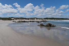
The Arthur – Pieman Conservation Area (APCA) stretches along the north-west coast of Tasmania, Australia and covers over 1,030 square kilometres (400 sq mi). Much of the reserve is between the Arthur River in the north, the Pieman River in the south and the Frankland and Donaldson Rivers to the east. It is a dynamic landscape which is being continually reshaped by wind, fire and water.
The area has a rich Aboriginal heritage which has left markers in the landscape, such as middens, hut depressions, artefact scatters and rock art. These special places and their associated cultural landscapes show that Aboriginal people in the past had a special relationship with the land - a relationship which continues with Aboriginal people today.
The Arthur – Pieman Conservation Area provides a range of opportunities for recreation, from surfing and diving to recreational off-road driving and fishing.
References
- ↑ "Arthur-Pieman Conservation Area". protectedplanet.net.