Arrondissement of Valenciennes
| Valenciennes | |
|---|---|
| Arrondissement | |
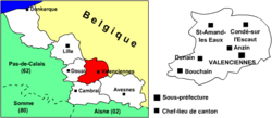 Location of Valenciennes in Nord-Pas-de-Calais | |
| Country | France |
| Region | Hauts-de-France |
| Department | Nord |
| Cantons | 6 |
| Communes | 82 |
| Subprefecture | Valenciennes |
| Area¹ | |
| • Total | 634.8 km2 (245.1 sq mi) |
| Population (2013) | |
| • Total | 349,486 |
| • Density | 550/km2 (1,400/sq mi) |
| ¹ French Land Register data, which exclude lakes, ponds, and glaciers larger than 1 km² as well as the estuaries of rivers. | |
The arrondissement of Valenciennes is an arrondissement of France in the Nord department in the Hauts-de-France region. It has 82 communes.
Composition
Cantons
The cantons of the arrondissement of Valenciennes are:
Communes
The communes of the arrondissement of Valenciennes, and their INSEE codes, are:
| 1. Abscon (59002) | 2. Anzin (59014) | 3. Artres (59019) |
| 4. Aubry-du-Hainaut (59027) | 5. Aulnoy-lez-Valenciennes (59032) | 6. Avesnes-le-Sec (59038) |
| 7. Bellaing (59064) | 8. Beuvrages (59079) | 9. Bouchain (59092) |
| 10. Bousignies (59100) | 11. Brillon (59109) | 12. Bruay-sur-l'Escaut (59112) |
| 13. Bruille-Saint-Amand (59114) | 14. Château-l'Abbaye (59144) | 15. Condé-sur-l'Escaut (59153) |
| 16. Crespin (59160) | 17. Curgies (59166) | 18. Denain (59172) |
| 19. Douchy-les-Mines (59179) | 20. Escaudain (59205) | 21. Escautpont (59207) |
| 22. Estreux (59215) | 23. Famars (59221) | 24. Flines-lès-Mortagne (59238) |
| 25. Fresnes-sur-Escaut (59253) | 26. Hasnon (59284) | 27. Haspres (59285) |
| 28. Haulchin (59288) | 29. Haveluy (59292) | 30. Hergnies (59301) |
| 31. Hordain (59313) | 32. Hélesmes (59297) | 33. Hérin (59302) |
| 34. La Sentinelle (59564) | 35. Lecelles (59335) | 36. Lieu-Saint-Amand (59348) |
| 37. Lourches (59361) | 38. Maing (59369) | 39. Marly (59383) |
| 40. Marquette-en-Ostrevant (59387) | 41. Mastaing (59391) | 42. Maulde (59393) |
| 43. Millonfosse (59403) | 44. Monchaux-sur-Écaillon (59407) | 45. Mortagne-du-Nord (59418) |
| 46. Neuville-sur-Escaut (59429) | 47. Nivelle (59434) | 48. Noyelles-sur-Selle (59440) |
| 49. Odomez (59444) | 50. Oisy (59446) | 51. Onnaing (59447) |
| 52. Petite-Forêt (59459) | 53. Prouvy (59475) | 54. Préseau (59471) |
| 55. Quarouble (59479) | 56. Quiévrechain (59484) | 57. Quérénaing (59480) |
| 58. Raismes (59491) | 59. Rœulx (59504) | 60. Rombies-et-Marchipont (59505) |
| 61. Rosult (59511) | 62. Rouvignies (59515) | 63. Rumegies (59519) |
| 64. Saint-Amand-les-Eaux (59526) | 65. Saint-Aybert (59530) | 66. Saint-Saulve (59544) |
| 67. Sars-et-Rosières (59554) | 68. Saultain (59557) | 69. Sebourg (59559) |
| 70. Thiant (59589) | 71. Thivencelle (59591) | 72. Thun-Saint-Amand (59594) |
| 73. Trith-Saint-Léger (59603) | 74. Valenciennes (59606) | 75. Verchain-Maugré (59610) |
| 76. Vicq (59613) | 77. Vieux-Condé (59616) | 78. Wallers (59632) |
| 79. Wasnes-au-Bac (59645) | 80. Wavrechain-sous-Denain (59651) | 81. Wavrechain-sous-Faulx (59652) |
| 82. Émerchicourt (59192) |
External links
This article is issued from
Wikipedia.
The text is licensed under Creative Commons - Attribution - Sharealike.
Additional terms may apply for the media files.