Arredondo, Cantabria
| Arredondo | ||
|---|---|---|
| Municipality | ||
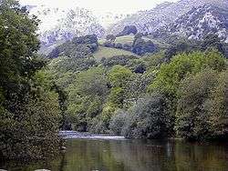 Asón River in Arredondo | ||
| ||
_Mapa.svg.png) | ||
 Arredondo Location in Spain | ||
| Coordinates: 43°16′33″N 3°36′2″W / 43.27583°N 3.60056°WCoordinates: 43°16′33″N 3°36′2″W / 43.27583°N 3.60056°W | ||
| Country |
| |
| Autonomous community | Cantabria | |
| Province | Cantabria | |
| Comarca | Asón valley | |
| Judicial district | Laredo | |
| Capital | Arredondo | |
| Government | ||
| • Alcalde | Luis Alberto Santander Peral (2007) (PRC) | |
| Area | ||
| • Total | 46.83 km2 (18.08 sq mi) | |
| Elevation | 161 m (528 ft) | |
| Population (2008) | ||
| • Total | 532 | |
| • Density | 11/km2 (29/sq mi) | |
| Time zone | UTC+1 (CET) | |
| • Summer (DST) | UTC+2 (CEST) | |
| Postal code | 39813 | |

Arredondo (Arredondu incantabrian) is a municipality located in the autonomous community of Cantabria, Spain. According to the 2007 census, the city has a population of 569 inhabitants.
Towns
- Alisas(Alisas)
- Arredondo (Capital)(Arredondu)
- Asón(Asón)
- El Avellanal(L'Avenllanal)
- La Iglesia(La Ilesia)
- Rocías(Rocías)
- La Roza(La Roza)
- Socueva(Socueva)
- Tabladillo(Tabladillu)
- Val del Asón(Valdasón or Val d'Asón)
External links
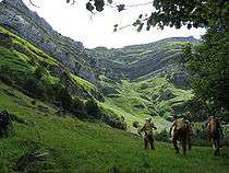
Access to Water Cave, in the municipality of Arredondo.
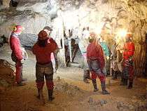
Caving in the Cave of Coventosa, in the municipality of Arredondo.
This article is issued from
Wikipedia.
The text is licensed under Creative Commons - Attribution - Sharealike.
Additional terms may apply for the media files.