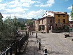
Cartes
| Cartes | |
|---|---|
| Municipality | |
 Cartes' Consistorial House | |
_Mapa.svg.png) Location of Cartes | |
 Cartes Location in Spain | |
| Coordinates: 43°19′32″N 4°4′5″W / 43.32556°N 4.06806°WCoordinates: 43°19′32″N 4°4′5″W / 43.32556°N 4.06806°W | |
| Country |
|
| Autonomous community |
|
| Province | Cantabria |
| Comarca | Besaya valley |
| Judicial district | Torrelavega |
| Capital | Cartes |
| Government | |
| • Alcalde | Saturnino Castanedo Saiz (2007) (PSC-PSOE) |
| Area | |
| • Total | 19.02 km2 (7.34 sq mi) |
| Elevation | 40 m (130 ft) |
| Population (2009) | |
| • Total | 5.118 |
| • Density | 0.27/km2 (0.70/sq mi) |
| Time zone | UTC+1 (CET) |
| • Summer (DST) | UTC+2 (CEST) |
| Postal code | 39311 |
| Website | Official website |
Cartes is a municipality located in the autonomous community of Cantabria, Spain. According to the 2009 census, the city has a population of 5.118 inhabitants.
External links
- Cartes - Cantabria 102 Municipios
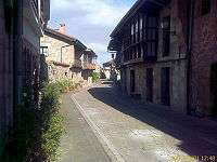
Streets in Cartes
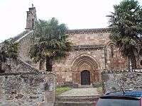
Church of Santa María, Yermo, municipality of Cartes
| Wikimedia Commons has media related to Cartes. |
This article is issued from
Wikipedia.
The text is licensed under Creative Commons - Attribution - Sharealike.
Additional terms may apply for the media files.