Arida, Lebanon
| Arida العريضة | |
|---|---|
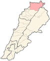
 Arida Location in Lebanon | |
| Coordinates: 34°38′00″N 35°58′40″E / 34.63333°N 35.97778°ECoordinates: 34°38′00″N 35°58′40″E / 34.63333°N 35.97778°E | |
| Country |
|
| Governorate | Akkar |
| District | Akkar |
| Time zone | UTC+2 (EET) |
| • Summer (DST) | +3 |
Arida (Arabic: العريضة) is a village in northern Lebanon, on the Syrian border, which is formed by the mouth of the Nahr al-Kabir al-Janoubi. It is located in the Akkar District of the Akkar Governorate.[1] The Arida Border Crossing is the coastal border crossing between Lebanon and Syria.
References
This article is issued from
Wikipedia.
The text is licensed under Creative Commons - Attribution - Sharealike.
Additional terms may apply for the media files.