Argentina–Chile border
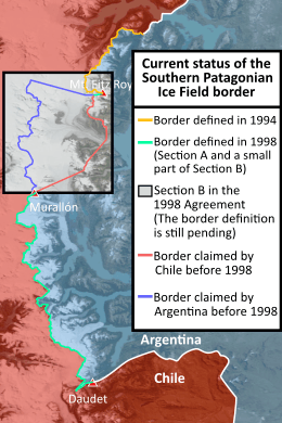
The Argentina–Chile border is the longest international border of South America and the third longest in the world after the Canada–United States border and the Kazakhstan–Russia border. With a length of 5,150 kilometres (3,200 mi), it separates Argentina from Chile along the Andes and on the islands of Tierra del Fuego. However, there are some border disputes, particularly around the Southern Patagonian Ice Field.
Plot
The northern end of the border is a tripoint it forms with those at the Argentina-Bolivia border and the Bolivia-Chile border in Atacama desert. It extends south to the Strait of Magellan and ends on Isla Grande de Tierra del Fuego. It separates the island into two to its coast a few kilometres south west of Ushuaia.
In November 1984 in the southern border area is finally established after long negotiations and mediation of John Paul II by the Treaty of Peace and Friendship of 1984 between Chile and Argentina, a perpetual treaty, signed at the Vatican by representatives of both countries.
On 16 December 1998, an agreement between Argentina and Chile was signed to set the border line from Mount Fitz Roy and Mount Daudet and finish with an historical dispute. However both countries didn't agree in the section between Mount Fitz Roy and Mount Murallón, and the border is still pending to be defined.
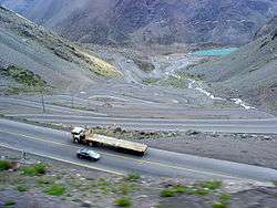
The city of Mendoza, in Argentina, is one of the largest cities located near the border.
See also
- Beagle Conflict, a border dispute between Chile and Argentina over the possession of Picton, Lennox and Nueva islands and the scope of the maritime jurisdiction associated with those islands that brought the countries to the brink of war in 1978.
- Boundary Treaty of 1881[1], a treaty signed on July 23rd 1881 by Bernardo de Irigoyen and Francisco de Borja Echeverría, which sought to clarify the existing Chile-Argentina border and establish a definite border between the two countries.
External links
- (in Spanish) " Y Cronología REFERENCIAS GENERAL SOBRE LOS Acuerdos Y Tratados bordering SUSCRITOS POR ARGENTINA Y CHILE (1820-1998) '" on the site soberaniachile.cl '
- (in French) The Argentine-Chilean border '" on the site' 'persee.fr'
- ↑ "Boundary Treaty of 1881 between Chile and Argentina", Wikipedia, 2018-03-23, retrieved 2018-10-09