Archipelago of San Bernardo
| Native name: Islas de San Bernardo | |
|---|---|
 Location map of the Archipelago of San Bernardo | |
| Geography | |
| Location | Caribbean Sea |
| Coordinates | 9°45′28″N 75°46′24″W / 9.7578°N 75.7734°WCoordinates: 9°45′28″N 75°46′24″W / 9.7578°N 75.7734°W |
| Adjacent bodies of water | Gulf of Morrosquillo |
| Total islands | 10 |
| Major islands | Tintipán Island, Múcura Island, Palma Island |
| Area | 213 km2 (82 sq mi) |
| Administration | |
|
Colombia | |
| Department |
Bolívar Sucre (Boquerón Island) |
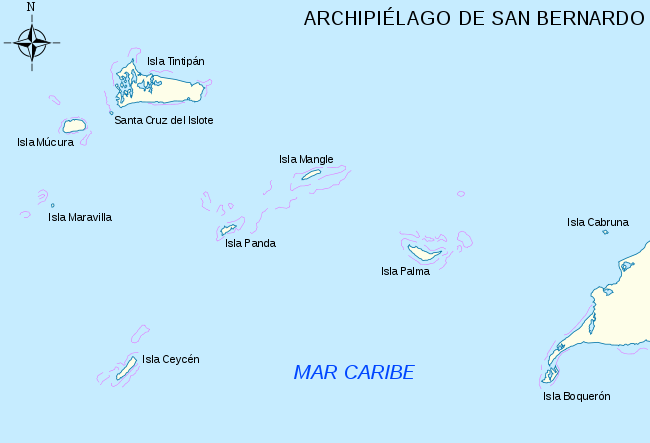
The Archipelago of San Bernardo (Spanish: Archipiélago de San Bernardo, Islas de San Bernardo[1]) is a set of nine[2] coastal coral islands and one artificial island (ten in total)[3] belonging to and governed by Colombia, located in the Gulf of Morrosquillo in the Caribbean Sea, with an approximate area of 213 km².[4] Administratively, the archipelago belongs to the Bolívar Department,[1] with the exception of Boquerón Island, which belongs to the Sucre Department.[5] It consists of Boquerón Island, Cabruna Island, Ceycén Island, Mangle Island, Múcura Island, Palma Island, Panda Island, Santa Cruz del Islote (English: Santa Cruz Islet, an artificial island), Tintipán Island and Maravilla Island.
Since 1996, part of the archipelago belongs to the Rosario and San Bernardo Corals National Natural Park.
Lodging facilities are present on some of the islands, primarily Múcura Island and Palma Island.[3]
Flora and fauna
Waters around the islands have fish and turtles, and the islands have significant tropical flora.[2]
Geography
.PNG)
See also
References
- 1 2 "Geografía". Bolívar sí avanza (in Spanish). Government of Bolívar Department. Retrieved January 15, 2017.
- 1 2 Alegría, Ciro; Varona. Dora (1995). Fábulas y leyendas americanas (in Spanish). Andres Bello. p. 31. ISBN 9561308886.
- 1 2 Colombia. Lonely Planet. 2009. p. 186. ISBN 1742203264.
- ↑ Informe del Estado de los Ambientes Marinos y Costeros en Colombia Año 2000. (in Spanish)
- ↑ "Plan de desarrollo 2008-2011 de San Onofre, Sucre" (PDF) (in Spanish). Mayoralty of San Onofre, Sucre. Retrieved April 15, 2017.
Further reading
| Wikimedia Commons has media related to Archipelago of San Bernardo. |
- Box, Ben (2013). Cartagena & Caribbean Coast. Footprint Travel Guides. pp. 48–49. ISBN 1909268380.
- "Xestospongia caycedoi Zea & van Soest, 1986". World Register of Marine Species. Retrieved 10 January 2015.
- United States Hydrographic Office (1920). Central America and Mexico Pilot (East Coast) from Gallinas Point, Colombia, to the Rio Grande. U.S. Government Printing Office. pp. 65–66.
Recreational dive sites in Colombia | ||
|---|---|---|
| Caribbean coast |  | |
| Caribbean insular | ||
| Pacific | ||
| Andean | ||