Arcadia, Michigan
| Arcadia, Michigan | |
|---|---|
| Census-designated place | |
 Arcadia, Michigan  Arcadia, Michigan | |
| Coordinates: 44°29′35″N 86°13′54″W / 44.49306°N 86.23167°WCoordinates: 44°29′35″N 86°13′54″W / 44.49306°N 86.23167°W | |
| Country | United States |
| State | Michigan |
| County | Manistee |
| Area[1] | |
| • Total | 0.522 sq mi (1.35 km2) |
| • Land | 0.522 sq mi (1.35 km2) |
| • Water | 0 sq mi (0 km2) |
| Elevation | 594 ft (181 m) |
| Population (2010)[1] | |
| • Total | 291 |
| • Density | 560/sq mi (220/km2) |
| Time zone | UTC-5 (Eastern (EST)) |
| • Summer (DST) | UTC-4 (EDT) |
| ZIP code | 49613 |
| Area code(s) | 231 |
| GNIS feature ID | 620195[2] |
Arcadia is an unincorporated community and census-designated place in Arcadia Township, Manistee County, Michigan, United States. Its population was 291 as of the 2010 census.[1] The community is located along M-22 and the Lake Michigan shore. Arcadia has a post office with ZIP code 49613.[3][4]
Geography
According to the U.S. Census Bureau, the community has an area of 0.522 square miles (1.35 km2), all of it land.[1]
References
- 1 2 3 4 "2010 Census Gazetteer Files - Places: Michigan". U.S. Census Bureau. Retrieved May 5, 2018.
- ↑ "Arcadia". Geographic Names Information System. United States Geological Survey.
- ↑ United States Postal Service. "USPS - Look Up a ZIP Code". Retrieved May 5, 2018.
- ↑ "Postmaster Finder - Post Offices by ZIP Code". United States Postal Service. Retrieved May 5, 2018.
Municipalities and communities of Manistee County, Michigan, United States | ||
|---|---|---|
| City | 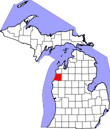 | |
| Villages | ||
| Charter township | ||
| General law townships | ||
| CDPs | ||
| Other unincorporated communities | ||
| Indian reservation | ||
| Footnotes | ‡This populated place also has portions in an adjacent county or counties | |
| Authority control |
|---|
This article is issued from
Wikipedia.
The text is licensed under Creative Commons - Attribution - Sharealike.
Additional terms may apply for the media files.