Arangeh
| Arangeh ارنگه | |
|---|---|
| village | |
 | |
 Arangeh | |
| Coordinates: 35°55′40″N 51°04′42″E / 35.92778°N 51.07833°ECoordinates: 35°55′40″N 51°04′42″E / 35.92778°N 51.07833°E | |
| Country |
|
| Province | Alborz |
| County | Karaj |
| Bakhsh | Asara |
| Rural District | Adaran |
| Population (2011) | |
| • Total | 302 |
| Time zone | UTC+3:30 (IRST) |
| • Summer (DST) | UTC+4:30 (IRDT) |
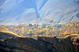
Arangeh[1] (Persian: ارنگه) is a village in Adaran Rural District, Asara District, Karaj County, Alborz Province, Iran. Arangeh is located in the Alborz Mountain range north of Karaj on the 18th Kilometers of Chalus road. It includes five villages: Arangeh Bozorg (Persian:ارنگه بزرگ), Abahrak (Persian:ابهرک), Sijan (Persian:سیجان), Sar-Ziarat (Persian:سرزیارت), Jay (Persian:جی), Charan (Persian:چاران), Gurab/Jurab (Persian:گوراب) and Khor (Persian:خور). The whole area is called Arangeh and the central and primary village of this area at is Arangeh Bozorg.[2]
At the 2006 census, its population was 136, in 46 families.[3] At the 2011 census, its population was 302, in 100 families.[4]
The village is notable for being the historical residence of the Khazeni Family, who were wealthy landowners during the Qajar dynasty.
References
- ↑ Arangeh can be found at GEOnet Names Server, at this link, by opening the Advanced Search box, entering "235108" in the "Unique Feature Id" form, and clicking on "Search Database".
- ↑ "ارنگه".
- ↑ "Census of the Islamic Republic of Iran, 1385 (2006)". Islamic Republic of Iran. Archived from the original (Excel) on 2011-11-11.
- ↑ "Census of the Islamic Republic of Iran, 1390 (2011)".
| Capital | |||||||||||||||||||||||||
|---|---|---|---|---|---|---|---|---|---|---|---|---|---|---|---|---|---|---|---|---|---|---|---|---|---|
| Districts |
| ||||||||||||||||||||||||