Araguaia River
| Araguaia River (Rio Araguaia) | |
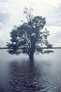 A tree in the Araguaia National Park in flood season | |
| Country | Brazil |
|---|---|
| States | Goiás, Mato Grosso, Tocantins, Pará |
| Cities | Aragarças, Barra do Garças |
| Mouth | Tocantins River |
| - coordinates | 5°22′34″S 48°43′08″W / 5.37611°S 48.71889°WCoordinates: 5°22′34″S 48°43′08″W / 5.37611°S 48.71889°W |
| Length | 1,910 km (1,187 mi) [1] |
| Basin | 358,125 km2 (138,273 sq mi) |
| Discharge | for Conceicaodo Araguaia |
| - average | 6,172 m3/s (217,962 cu ft/s) |
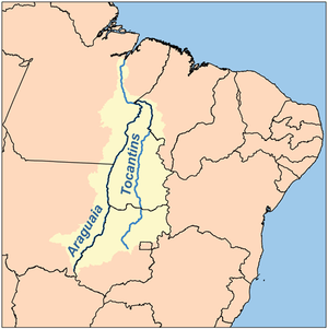 Map of the Araguaia/Tocantins Watershed | |
The Araguaia River (Portuguese: Rio Araguaia [ˈʁi.u ɐɾɐˈɡwaj.jɐ]) is one of the major rivers of Brazil, though it is almost equal in volume at its confluence with the Tocantins. It has a total length of approximately 2,627 km. Araguaia means "river of (red) macaws" in the Tupi language.
Geography
The Araguaia River comes from Goiás-Mato Grosso south borders. From there it flows northeast to a junction with the Tocantins near the town of São João.[2]
Along its course, the river forms the border between the states of Goiás, Mato Grosso, Tocantins and Pará. Roughly in the middle of its course the Araguaia splits into two forks (with the western one retaining the name Araguaia and the eastern one being called the Javaés River). These later reunite, forming the Ilha do Bananal, the world's largest river island.[2] The vein of the Javaés forms a broad inland where it pours back into the main Araguaia, a 100,000 hectare expanse of igapós flooded forest, blackwater river channels, and oxbow lakes called Cantão, protected by the Cantão State Park. This is one of the biologically richest areas of the eastern Amazon, with over 700 species of birds, nearly 300 species of fish, large populations species such as the giant otter, the black cayman, the world's largest freshwater fish, the pirarucú, and the Araguaian river dolphin (or Araguaian boto) all occurring within a large area.
A large portion of the Araguaia's course is navigable all year, but the river below the Cantão wetlands is interrupted by rapids.
The middle and lower basin of the river is in the Xingu-Tocantins-Araguaia moist forests ecoregion.[3] The combined watershed of Araguaia and Tocantins rivers (named the Araguaia Tocantins Basin) covers approximately 9.5% of Brazil's national territory. This area is an integral part of the Amazon biome. However, the Araguaia River is not a tributary of the Amazon.
"Araguaia" means "River of the Macaws" in the native Tupi language.
Tributaries
Its principal tributary is the Rio das Mortes, which rises in the Serra de São Jerônimo, near Cuiabá, Mato Grosso, and is navigable to Pará. Other important tributaries include the Bonito, Garcas, Tapirape and the Formoso or Cristalino on the west, and the Pitombas, Claro, Vermelho, Tucupa and Chavante on the east.[4]
History
It was explored in part by Henri Coudreau in 1897.[5] From 1972 to 1974 this region was the scene of a conflict between left-wing guerrilla movements and forces supporting the then military dictatorship.
Towns
Among the most important settlements on the banks of the Araguaia River are (in a downstream order):
Tourism
Several parts of the river's course are protected by national parks and other reserves like the Emas National Park and the Araguaia National Park. The Araguaia has "beaches" - bright sandy banks that seam the stream from May to October.
See also
References
- ↑ Ziesler, R.; Ardizzone, G.D. (1979). "Amazon River System". The Inland waters of Latin America. Food and Agriculture Organization of the United Nations. ISBN 92-5-000780-9. Archived from the original on 21 October 2013.
- 1 2 "Araguaia River". Encyclopædia Britannica. Encyclopædia Britannica Inc. 2015. Retrieved 2015-02-13.
- ↑ Sears, Robin, Eastern Amazonian - Brazil (NT0180), WWF: World Wildlife Fund, retrieved 2017-03-22
- ↑

- ↑ Coudreau's Voyage au Tocantins-Araguaya (Paris, 1897)
External links
- Rio Araguaia (information for tourists in Portuguese, Spanish and English)
- Hotel, turismo, pescaria, passeios ecológicos Araguaia,Luiz Alves, Bananal, Cristalino
- hydrographic information (in Portuguese)
- Basin map (in Portuguese)
- Tocantins state, with Rivers v-Brazil.com
- Pará state, with Rivers v-Brazil.com
- Instituto Araguaia
- Brazilian Ministry of Transport