Arachova
| Arachova Αράχωβα | |
|---|---|
 Arachova | |
 Arachova Location within the regional unit  | |
| Coordinates: 38°29′N 22°35′E / 38.483°N 22.583°ECoordinates: 38°29′N 22°35′E / 38.483°N 22.583°E | |
| Country | Greece |
| Administrative region | Central Greece |
| Regional unit | Boeotia |
| Municipality | Distomo-Arachova-Antikyra |
| • Municipal unit | 139.45 km2 (53.84 sq mi) |
| Elevation | 968 m (3,176 ft) |
| Population (2011)[1] | |
| • Municipal unit | 2,770 |
| • Municipal unit density | 20/km2 (51/sq mi) |
| Time zone | UTC+2 (EET) |
| • Summer (DST) | UTC+3 (EEST) |
| Postal code | 320 04 |
| Area code(s) | 22670 |
| Vehicle registration | ΒΙ |
| Website | arachova.com |
Arachova (Greek: Αράχωβα, also Αράχοβα) is a mountain town and a former municipality in the western part of Boeotia, Greece. Since the 2011 local government reform it is a municipal unit, part of the municipality Distomo-Arachova-Antikyra.[2] Its name is of South Slavic origin and denotes a place with walnut trees. It is a tourist destination due to its location in the mountains, its traditions and its proximity to the town of Delphi.
Greek rebels under Georgios Karaiskakis defeated the Ottomans at the 1826 Battle of Arachova.
The Formaela cheese from Arachova has been designated as a protected designation of origin.[3] Nearby Arachova, modern ski facilities are popular with visitors. Although contemporary culture tends to outdo regional folklore, the town maintains some local customs and demonstrates them at celebrations on 23 April, in the honor of the patron Saint George.
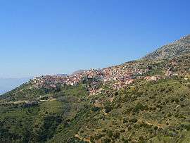
Arachova has a panoramic view, uphill small houses and the cobbled streets show a picturesque architecture. The town center includes a huge and steep cliff, the Bell Tower, covered with dense ivy. At the top of the tower is a large 10m height clock. Arachova is famous for its black wine, its "brusque", the colorful textiles, carpets and rugs, handicrafts and woodcut creations as well.
Geography
Arachova is situated at about a 970 m (3182 ft) elevation on the southern slope of Mount Parnassus, above the valley of the river Pleistos. The municipal unit has an area of 139.448 km2.[4] Arachova is located 8 km E of Delphi, 9 km northwest of Distomo, 18 km southeast of Amfissa and 26 km west of Livadeia. The Greek National Road 48 (Naupactus - Delphi - Livadeia) passes through the town. The Parnassos Ski Centre is situated to the north.
Historical population
| Year | Population |
|---|---|
| 1981 | 2,910 |
| 1991 | 3,084 |
| 2001 | 4,158 |
| 2011 | 2,770 |
Gallery
 View of the town hall
.JPG) A street in Arachova
A street in Arachova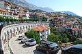 View of Arachova
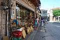 Another street of the city
References
- ↑ "Απογραφή Πληθυσμού - Κατοικιών 2011. ΜΟΝΙΜΟΣ Πληθυσμός" (in Greek). Hellenic Statistical Authority.
- ↑ Kallikratis law Greece Ministry of Interior (in Greek)
- ↑ WIPO
- ↑ "Population & housing census 2001 (incl. area and average elevation)" (PDF) (in Greek). National Statistical Service of Greece. Archived from the original (PDF) on 2015-09-21.
External links
See also
Places adjacent to Arachova | |
|---|---|
| Wikimedia Commons has media related to Arachova. |