Ar'ara
Ar'ara
| |
|---|---|
| Hebrew transcription(s) | |
| • ISO 259 | ʕarˁara |
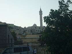 Mosque in Ar'ara | |
 Ar'ara | |
| Coordinates: 32°29′40″N 35°05′39″E / 32.49444°N 35.09417°ECoordinates: 32°29′40″N 35°05′39″E / 32.49444°N 35.09417°E | |
| Grid position | 159/211 PAL |
| District |
|
| Government | |
| • Type | Local council (from 1970) |
| Population (2017)[1] | |
| • Total | 24,528 |
| Name meaning | "The juniper tree"[2] |
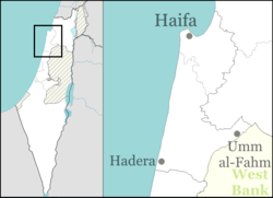
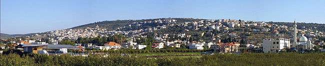
'Ar'ara (Arabic: عرعرة, Hebrew: עַרְעָרָה; lit. "Juniper tree")[2] is an Arab town in the Wadi Ara region in northern Israel. It is located south of Umm al-Fahm just northwest of the Green Line and is part of the Triangle. In 2017 the population was 24,528.[1]
History
Pottery sherds from Persian era have been found here.[3]
Burial complexes from the Roman period by Ar'ara have been excavated, revealing clay lamps and glass vessels and beads, commonly used in the 1st to 4th century C.E.[4] Tombs with niches, cut into rock, and Byzantine era ceramics have been found.[5]
In the Crusader period, the place was known as "Castellum Arearum". In the land-allocation made by sultan Baybars in 663 H. (1265-1266 C.E.), Ar'ara was shared between his amirs Ala' al-Din and Sayf al-Din Bayhaq al-Baghdadi.[6]
A few clay fragments from the Mamluk period have also been found at the same location as the Roman remains.[4]
Ottoman era
Ar'ara, like the rest of Palestine, was incorporated into the Ottoman Empire in 1517, and in 1596, Ar'ara appeared in Ottoman tax registers as being in the Nahiya of Sa'ra of the Liwa of Lajjun. It had a population of 8 Muslim households and paid a fixed tax rate of 25% on agricultural products, which included wheat, barley, summer crops, olives, and goats or beehives; a total of 9,000 akçe.[7]
By the eighteenth century, the village remained in the administrative district of Lajjun, but the revenue of the place was farmed for the Mutasarrıf of Jaffa.[8] In 1838, it was noted as a village in the Jenin district.[9]
In the late nineteenth century, the site was described as:
A village of moderate size on high ground, with a spring to the east, a second to the west and a well to the south. There are rock cut tombs near. The population is stated by Consul Rogers (1859) as 400, the cultivation then being 30 feddans.[10]
A population list from about 1887 showed that Ar'arah had about 600 inhabitants; all Muslims.[11]
British Mandate era
In the 1922 census of Palestine conducted by the British Mandate authorities, Ar'ara had a population 735, all Muslims.[12] This had increased in the 1931 census to 971, still all Muslims, in 150 houses.[13]
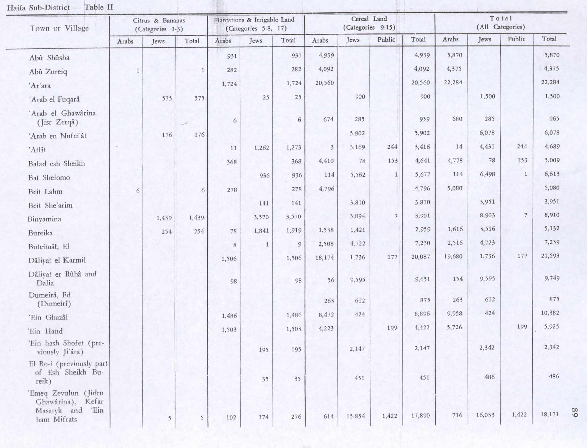
In the 1945 statistics, Ar'ara and Arah had a population of 2,290 Muslims,[14] 1,490 in Ar'ara and 800 in 'Ara,[15] and a privately owned land area of 29,537 dunums,[16] in addition to 5,802 dunams of publicly owned land.[17] Of this, 1,724 dunams were for plantations and irrigable land, 20,560 for cereals,[18] while 33 dunams were built-up (urban) land.[19]
State of Israel
Ar'ara was transferred from Jordanian to Israeli jurisdiction in 1949 under the Rhodes armistice agreements.[20]
By 1962 the area had been reduced to 7,269 dunums, partly due to expropriations of 8,236 dunums by the Israeli government in 1953–54.[16] One case of expropriation from a private landowner named Younis became a test case before the High Court of Israel in 1953.[21] The land had been confiscated by the government without notifying the owner.[21] In 1954 the court ruled that the law did not require the owner to be notified and did not provide a right for the owner to contest the confiscation in advance.[21] This ruling and one other effectively ended the possibility of land owners using the courts to contest the confiscation of their land.[21] The neighboring village of ʿAra was merged with Ar'ara in 1985.
Maqam Shaykh Khalaf
Maqam Shaykh Khalaf is the only building which was noted by the antiquities authorities in the Mandate area, and it is located on a slope by the highest point in the village, set in the middle of extensive graveyards. The Maqam is a single rectangular chamber, covered by a dome. The two top courses are chamfered towards the dome. On the north side is a doorway, and double window set inside shallow arches. There is also a set of windows on the west side. Inside there are three cenotaphs, located east-west, close to the west wall. A mihrab is located on the south wall. The date of the building is not known, but according to A. Petersen (who inspected the place in 1994), the architecture indicate an eighteenth or early nineteenth century date.[22]
See also
References
- 1 2 "List of localities, in Alphabetical order" (PDF). Israel Central Bureau of Statistics. Retrieved August 26, 2018.
- 1 2 Palmer, 1881, p.144
- ↑ Zertal, 2016, p. 134
- 1 2 Massarwa, 2007, Ar‘ara Final Report
- ↑ Dauphin, 1998, p. 747
- ↑ Ibn al-Furat, edition Lyons and Lyons, I, p.102; II, p.81. Cited in Petersen, 2001, p. 94
- ↑ Hütteroth and Abdulfattah, 1977, p. 159
- ↑ Cohen, 1973, p.175, Cited in Petersen, 2002, p.94
- ↑ Robinson and Smith, 1841, vol 3, 2nd Appendix, p. 131
- ↑ Conder and Kitchener, 1882, SWP I, p. 41. Also cited in Petersen, 2001, p.94.
- ↑ Schumacher, 1888, p. 179
- ↑ Barron, 1923, Table XI, Sub-district of Haifa, p. 34
- ↑ Mills, 1932, p. 87
- ↑ Department of Statistics, 1945, p. 13
- ↑ Department of Statistics, 1945, p. 15 note a
- 1 2 Sabri Jiryis (1976). "The Land Question in Israel". MERIP Reports. 47: 5–20+24–26.
- ↑ Government of Palestine, Department of Statistics. Village Statistics, April, 1945. Quoted in Hadawi, 1970, p. 47
- ↑ Government of Palestine, Department of Statistics. Village Statistics, April, 1945. Quoted in Hadawi, 1970, p. 89
- ↑ Government of Palestine, Department of Statistics. Village Statistics, April, 1945. Quoted in Hadawi, 1970, p. 139
- ↑ Family Affair: The Masarwah-Marzuks, Haaretz
- 1 2 3 4 Hanna Dib Nakkara (1985). "Israeli Land Seizure under Various Defense and Emergency Regulations". Journal of Palestine Studies. 14 (2): 13–34. doi:10.1525/jps.1985.14.2.00p0125a.
- ↑ Petersen, 2001, p.94
Bibliography
- Abel, F. M. (1938). Geographie de la Palestine. 2 Geographie Politique. Les villes. Librairie Lecoffre. (II, p. 88)
- Baedeker, K., 1867, Palestine and Syria. A Handbook for Travellers, Dulan & Co., London ( p. 299)
- Barron, J.B., ed. (1923). Palestine: Report and General Abstracts of the Census of 1922. Government of Palestine.
- Cohen, Amnon (1973). Palestine in the Eighteenth Century: Patterns of Government and Administration. Jerusalem: Magnes Press, Hebrew University. ISBN 1-59045-955-5. Cited in Petersen, (2001)
- Conder, C.R.; Kitchener, H.H. (1882). The Survey of Western Palestine: Memoirs of the Topography, Orography, Hydrography, and Archaeology. 2. London: Committee of the Palestine Exploration Fund.
- Dauphin, Claudine (1998). La Palestine byzantine, Peuplement et Populations. BAR International Series 726 (in French). III : Catalogue. Oxford: Archeopress. ISBN 0-860549-05-4.
- Department of Statistics (1945). Village Statistics, April, 1945. Government of Palestine.
- Gorzalczany, Amir; Mahajna, Shireen; Massarwa, Abdallah (2009-03-12). "'Ar'ara (Southwest) Final Report" (121). Hadashot Arkheologiyot – Excavations and Surveys in Israel.
- Hadawi, S. (1970). Village Statistics of 1945: A Classification of Land and Area ownership in Palestine. Palestine Liberation Organization Research Center.
- Hartmann, R., (1910), 'Die Strasse von Damascus nach Kairo', ZDMG (=Zeitschrift des Deutschen Morgenlandische Gesellschaft), 64, ( pp. 665–702) (p. 700)
- Hütteroth, Wolf-Dieter; Abdulfattah, Kamal (1977). Historical Geography of Palestine, Transjordan and Southern Syria in the Late 16th Century. Erlanger Geographische Arbeiten, Sonderband 5. Erlangen, Germany: Vorstand der Fränkischen Geographischen Gesellschaft. ISBN 3-920405-41-2.
- Ibn al-Furat (1971). Jonathan Riley-Smith, ed. Ayyubids, Mamluks and Crusaders: Selections from the "Tarikh Al-duwal Wal-muluk" of Ibn Al-Furat : the Text, the Translation. 2. Translation by Malcolm Cameron Lyons, Ursula Lyons. Cambridge: W. Heffer.
- Massarwa, Abdallah (2007-12-24). "Ar'ara Final Report" (119). Hadashot Arkheologiyot – Excavations and Surveys in Israel.
- Massarwa, Abdallah (2009-03-12). "'Ar'ara (Southwest) Final Report" (121). Hadashot Arkheologiyot – Excavations and Surveys in Israel.
- Massarwa, Abdallah (2011-07-06). "Ar'ara Final Report" (123). Hadashot Arkheologiyot – Excavations and Surveys in Israel.
- Massarwa, Abdallah (2013-06-02). "'Ar'ara (Southwest), Qazir" (125). Hadashot Arkheologiyot – Excavations and Surveys in Israel.
- Mills, E., ed. (1932). Census of Palestine 1931. Population of Villages, Towns and Administrative Areas. Jerusalem: Government of Palestine.
- Oren, Eliran; Kirzner, Dan (2013-06-13). "'Ar'ara, Survey" (125). Hadashot Arkheologiyot – Excavations and Surveys in Israel.
- Palmer, E.H. (1881). The Survey of Western Palestine: Arabic and English Name Lists Collected During the Survey by Lieutenants Conder and Kitchener, R. E. Transliterated and Explained by E.H. Palmer. Committee of the Palestine Exploration Fund.
- Petersen, Andrew (2001). A Gazetteer of Buildings in Muslim Palestine (British Academy Monographs in Archaeology). 1. Oxford University Press. ISBN 978-0-19-727011-0.
- Robinson, E.; Smith, E. (1841). Biblical Researches in Palestine, Mount Sinai and Arabia Petraea: A Journal of Travels in the year 1838. 3. Boston: Crocker & Brewster.
- Schumacher, G. (1888). "Population list of the Liwa of Akka". Quarterly statement - Palestine Exploration Fund. 20: 169–191.
- Zertal, A. (2016). The Manasseh Hill Country Survey. 3. Boston: BRILL. ISBN 9004312307.
External links
- Official website
- Welcome To 'Ar'ara
- Survey of Western Palestine, Map 8: IAA, Wikimedia commons