Andrott
| Native name: ആന്ധ്രോത് | |
|---|---|
 Andrott Location of Andrott Island in Lakshadweep | |
| Geography | |
| Location | Arabian Sea |
| Coordinates | 10°49′N 73°40′E / 10.81°N 73.67°ECoordinates: 10°49′N 73°40′E / 10.81°N 73.67°E |
| Archipelago | Lakshadweep |
| Adjacent bodies of water | Indian Ocean |
| Total islands | 1 |
| Major islands |
|
| Area | 4.98 km2 (1.92 sq mi)[1] |
| Length | 1.4 km (0.87 mi) |
| Width | 4.7 km (2.92 mi) |
| Coastline | 10 km (6 mi) |
| Highest elevation | 0 m (0 ft) |
| Administration | |
| Territory | Union territory of Lakshadweep |
| District | Lakshadweep |
| Island group | Laccadive Islands |
| Tehsils of India | Andrott |
| Subdivisions of India | Andrott |
| Largest settlement | Andrott (pop. 11000) |
| Demographics | |
| Population | 11464 (2014) |
| Pop. density | 2,300 /km2 (6,000 /sq mi) |
| Ethnic groups | Malayali, Mahls |
| Additional information | |
| Time zone | |
| PIN | 68255x |
| Telephone code | 0489x |
| ISO code | IN-LD-07[2] |
| Official website |
www |
| Literacy | 84.74% |
| Avg. summer temperature | 32.0 °C (89.6 °F) |
| Avg. winter temperature | 28.0 °C (82.4 °F) |
| Sex ratio | 0.9685 ♂/♀ |
Andrott Island (Malayalam: ആന്ധ്രോത് ദ്വീപ്), also known as Androth Island, is a small inhabited island in the Union Territory of Lakshadweep, a group of 36 coral islands scattered in the Arabian Sea off the western coast of India[3] It has a distance of 2,006 km (1,246 mi) south of the city of Delhi.
History
Andrott Island had been known as 'Divanduru' in the past, a name that is found in some old French maps. It belongs to the Laccadive Islands subgroup, which had been historically a part of the Arakkal Kingdom.[4]
Nowadays the island of Andrott is a protected territory and not a tourist destination.
Geography
Andrott Island is the nearest to the mainland from all the islands in the group[5] and it is also the longest, as well as the biggest (area-wise) island.
It is located approximately 198 kilometres (123 mi) from Kozhikode and 293 kilometres (182 mi) from Kochi.[6] The island has an area of 4.98 square kilometres (1.92 sq mi) and is the only island of the group to have a west-east orientation.[6] It has a lagoon area of 6.6 km2 (2.5 sq mi).
Demographics
Most of its inhabitants are Muslims and there is also a Hindu minority. The Saint Hasrat Ubaidullah, who is believed to have converted the Lakshadweep Islands to Islam, died here. His remains are entombed in the Jumah mosque.[7]
The island also houses several Buddhist archaeological remains.[6]
Administration
The island belongs to the township of Andrott of Andrott Tehsil.[8]
Climate
| Climate data for Andrott | |||||||||||||
|---|---|---|---|---|---|---|---|---|---|---|---|---|---|
| Month | Jan | Feb | Mar | Apr | May | Jun | Jul | Aug | Sep | Oct | Nov | Dec | Year |
| Average high °C (°F) | 30.3 (86.5) |
30.9 (87.6) |
32.2 (90) |
33.1 (91.6) |
32.8 (91) |
30.5 (86.9) |
29.9 (85.8) |
30.1 (86.2) |
30.0 (86) |
30.5 (86.9) |
30.4 (86.7) |
30.7 (87.3) |
31 (87.7) |
| Average low °C (°F) | 24.4 (75.9) |
24.8 (76.6) |
25.5 (77.9) |
26.3 (79.3) |
26.4 (79.5) |
24.9 (76.8) |
24.3 (75.7) |
24.9 (76.8) |
24.7 (76.5) |
24.7 (76.5) |
24.1 (75.4) |
24.0 (75.2) |
24.9 (76.8) |
| Average rainfall mm (inches) | 10.5 (0.413) |
2.4 (0.094) |
6.0 (0.236) |
25.9 (1.02) |
130.4 (5.134) |
401.7 (15.815) |
486.1 (19.138) |
238.6 (9.394) |
182.2 (7.173) |
166.5 (6.555) |
129.8 (5.11) |
90.2 (3.551) |
1,870.3 (73.633) |
| Source: India Meteorological Department (1965-1979)[9] | |||||||||||||
Image gallery
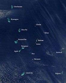 Satellite picture showing the atolls of the Lakshadweep except for Minicoy
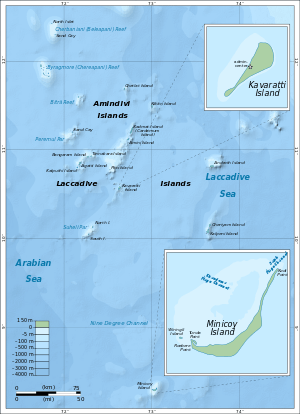 Map
Map
References
- ↑ "Islandwise Area and Population - 2011 Census" (PDF). Government of Lakshadweep. Archived from the original (PDF) on 2016-07-22.
- ↑ Registration Plate Numbers added to ISO Code
- ↑ Singh VS, Sarwade DV, Mondal NC, Nanadakumar MV, Singh B (October 2008). "Evaluation of groundwater resources in a tiny Andrott Island, Union Territory of Lakshadweep, India". Environmental Monitoring and Assessment. 158 (1–4): 145–54. doi:10.1007/s10661-008-0569-y. PMID 18839323. Retrieved 2008-11-20.
- ↑ Geneviève Bouchon, Mamale de Cananor, Librairie Droz, ISBN 9782600033541, p. 40
- ↑ "Androth Island - Lakshadweep U.T". Retrieved 2 February 2018.
- 1 2 3 "India9.com:Andrott Island".
- ↑ "Islands and Shoreline Lakshadweep". Retrieved 2 February 2018.
- ↑ "Tehsils info" (PDF). Retrieved 2 February 2018.
- ↑ "Climate of Andrott" (PDF). India meteorological department. Archived from the original (PDF) on 17 October 2015. Retrieved 31 May 2014.
External links
