Andrijevica Municipality
| Andrijevica Municipality Opština Andrijevica | ||
|---|---|---|
| Municipality | ||
| ||
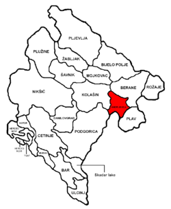 Andrijevica Municipality in Montenegro | ||
| Coordinates: 42°44′23″N 19°47′9″E / 42.73972°N 19.78583°ECoordinates: 42°44′23″N 19°47′9″E / 42.73972°N 19.78583°E | ||
| Country | Montenegro | |
| Seat | Andrijevica | |
| Area[1] | ||
| • Total | 340 km2 (130 sq mi) | |
| Population (2011) | ||
| • Total | 5,071 | |
| • Density | 15/km2 (39/sq mi) | |
| Time zone | UTC+1 (CET) | |
| • Summer (DST) | UTC+2 (CEST) | |
| Area code(s) | +382 51 | |
| ISO 3166 code | ME-01 | |
| Vehicle registration | AN | |
| Website |
www | |

Andrijevica Municipality is one of the municipalities of Montenegro. The center is Andrijevica.
Its territory is outspread on 340 km2 and it is surrounded by massives of mountains Komovi, Bjelasica and Prokletije.
Demographics
Andrijevica Municipality in 2011 had a population of 5,071.[2]
| Historical population | ||
|---|---|---|
| Year | Pop. | ±% |
| 1948 | 10,067 | — |
| 1953 | 10,327 | +2.6% |
| 1961 | 9,792 | −5.2% |
| 1971 | 8,966 | −8.4% |
| 1981 | 7,712 | −14.0% |
| 1991 | 6,696 | −13.2% |
| 2003 | 5,785 | −13.6% |
| 2011 | 5,071 | −12.3% |
References
| Capital City | ||
|---|---|---|
| Old Royal Capital | ||
| Municipalities | ||
This article is issued from
Wikipedia.
The text is licensed under Creative Commons - Attribution - Sharealike.
Additional terms may apply for the media files.